Maps of Africa

CHARTE von AFRICA
1 : 30000000 Afrika
Charte von Africa
1 : 30000000 Afrika
Composite: Africa.
1 : 8300000 Robert Laurie & James Whittle
Africa
1 : 18050000 Afrika Weiland, Karl Ferdinand Verlag des Geograph. Instituts
Stanford's library map of Africa / [Edward Stanford]
1 : 5977382 Annotatie: Oorspr. kaart op 4 bl; Oorspr. uitg.: London : Stanford, 1866; De kaart geeft de Britse heerschappij weer tijdens het hoogtepunt van de kolonisatie na de Eerste Wereldoorlog; Annotatie geografische gegevens: Schaalstokken op kaart: Eng: & Ital: Geo: miles; English stat: miles; French kilometres; French leagues; Portuguese leagues; Spanish miles, Turkish berri Edward Stanford 1827-1904 London : Stanford's Geographical Establishment

Africa
1 : 18500000 entw. und gezeichnet von C. F. Weiland Weimar : Verlag des Geograph. Instituts
AFRICÆ | nova descriptio
Auct: Guiljelmo Blaeuw [Amsterdam : Joan Blaeu]
Africa
A new general atlas of modern geography, consisting of a complete collection of maps of the four quarters of the globe Wyld, James James Wyld
Composite: Africa.
1 : 11200000 Lizars, Daniel
[Kaart], uit: Karte von Afrika / entworfen von F. Handtke ; bearbeitet und ergänzt im kartographischen Institut der Verlagshandlung
1 : 14500000 titelvariant: General-Karte von Afrika; Annotatie: Omslagtitel: General-Karte von Afrika; Annotatie geografische gegevens: Schaalstokken; Inzetkrt.: Das Deutsche Reich. - 1.14.500.000; Das mittlere Ost-Afrika. - 1.6.000.000. - Zum Vergleich: [Kgr. Sachsen] (elfde schaal); I. Lüderitz-Land (der südliche Theil von Deutsch-Südwestafrika, II. Das Kamerun-Gebiet, III. Togo-Gebiet und Sklavenküste (alle 1:3.000.000). - [Zum Vergleich:] Das Königr. Sachsen (zelfde schaal) Verlag von Carl Flemming, Glogau. Kartographisches Institut Glogau : Carl Flemming
Africae nova Tabula. [Karte], in: Gerardi Mercatoris et I. Hondii Newer Atlas, oder, Grosses Weltbuch, Bd. 1, S. 33.
1 Karte aus Atlas Mercator, Gerhard und Hondius, Jodocus Jansson, Jan
[Recto], uit: Africae nova tabula / auct. Henr. Hondio 1631
1 : 20000000 Annotatie: Afkomstig uit: Gerardi Mercatoris Atlas ou Representation du monde universel ... - Amsterodami : sumptibus ... Henrici Hondij, 1633, of uit: L'appendice de l'atlas de Gerard Mercator et Iudocus Hondius ... - Amsterdam : Henry Hondius, 1633, of uit een latere editie Hondius, Henricus [Amsterdam : Henr. Hondius]
Africa [...] [Karte], in: Atlas, sive, Cosmographicae meditationes de fabrica mundi et fabricati figura, S. 68.
1 Karte aus Atlas Mercator, Gerhard
Totius Africae accuratissima tabula [...]
1 : 20000000 denuo correcte revisa, multis locis aucta, in partes tam maiores quam minores divisa per F. de Witt Amstel. [Amsterdam] : ex officina Cóvens et Mortier
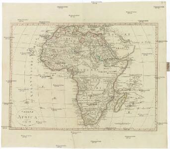
Africa.
1 : 50000000 Seaman, James V.
Afrika, volgens de nieuwste waarnemingen
1 : 74000000 Te Amsterdam : by Arend Fokke, Simz.
Composite: Africa.
1 : 8400000 Boulton, S.
L'Afrique
1 : 20700000 Afrika Sanson, Guillaume Cordier, Louis chez H. Iaillot
Africa
Afrika Hase, Johann Matthias Hauer, Daniel Adam impensis Homannianorum Heredum
Africa
Afrika Hase, Johann Matthias impensis Homannianorum Heredum
A new map of Africk, shewing its present general divisions chief cities, or towns, rivers, mountain &c.
1 : 25000000 Wells, Edward Sheldonian Theatre

Africa
1 : 1
Afrika
Atlas der Pflanzengeographie über alle Theile der Erde Rudolphi, Ludwig Verlag der Nicolaischen Buchhandlung
Afrique Physique.
1 : 29500000 Migeon, J.
Africae noviss. cateres tabula
1 : 22200000 auct. J. Bormeester [Amsterdam] : [s.n.]
[Neuer Atlas der ganzen Erde nach den neuesten Bestimmungen ... : IV.] Afrika
Entworfen und gezeichnet von Dr. F.W. Streit H. Leutemann sc. Leipzig : J.C. Hinrichs'sche Buchhandlung
Africa : laid down partly from the observations of the Royal Academy of Sciences and partly from the improvements of Herman Moll Geogr. and compared with the maps of Sanson, Nolin, De Fer, De Lisle and other modern geographers / engraved by Emanuel Bowen
1 : 9000000 Bowen, Emanuel [London : John Bowles]