Maps of Lombardy

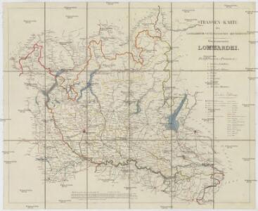
Strassen-Karte des Lombardisch-Venezianischen Koenigreiches
1 : 430000 Lombardie (Itálie)
Strassen-Karte des Lombardisch-Venezianischen Koenigreiches
1 : 435300 Lombardie (Itálie)
Carta geografica-postale delle province Lombarde
1 : 500000 Lombardie (Itálie)
Strassen-Karte des Lombardisch-Venezianischen Koenigreiches
1 : 432000 Lombardie (Itálie)
Cursus Padi per Longobardiam
1 : 530000 Mollova mapová sbírka Seutter, Matthäus Seutter, Matthäus


Dolní Lombardie]
Mollova mapová sbírka Fer, Nicolas de Loon, Herman van Danet, Guillaume
Le Duché de Milan dans toute son estendüe divisé en ses principales parties, avec les estats et frontieres qui l'environnent
1 : 520000 par Pierre Mortier A Amsterdam : chez P. Mortier
Ducatus Mediolanensis cum adjacentibus Principat. Et Dominiis


Ducatus Mediolanensis Placentini et Parmensis nova tabula
1 Karte : Kupferdruck ; 32 x 38 cm Weigel; Kauffer Christoph Weigel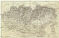
[Lombardie a Benátsko]
1 : 1010000 Lombardie (Itálie)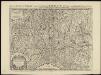
Le Duché de Milan dans toute son estendüe divisé en ses principales parties, avec les estats et frontieres qui l'environnent, où sont exactement marquée les route[s] des impériaux, &c
1 : 520000 par Pierre Mortier A Amsterdam : chez P. Mortier
XI, uit: General-Karte des oesterreichischen Kaiserstaates mit einem grossen Theile der angrenzenden Länder / durch Josef Scheda ... bearb. und hrsg
1 : 576000 Annotatie geografische gegevens: Maatstokken: oesterreichische Meilen, geografische oder deutsche Meilen, preussische Meilen, türkische Berri, französische Lieues, russische Werste; Maatstok per blad: wiener Klafter, öster. Meilen; Blad XIX: statistische en taalkundige informatie; Blad XIX: legenda [Wien : K.K. Militärisch-Geografisches Institut]
Carta geografica e postale del regno Lombardo-Veneto
1 : 375000 Belluno (Itálie) Pinchetti, C. Brenna, Geog. Gio. Gio. Cogliati
Lombardia
1 : 250000 Lombardie (Itálie) Arrigoni, Ferdinando Artaria, Ferdinando Ferdinando Arrigoni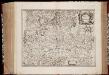
Stato di Milano
1 : 500000 Annotatie: Origineel is Blad 155 in atlas factice; Annotatie geografische gegevens: Schaalstok: Scala di miglia tredeci d'Italia [Amstelodami] : [apud Ioannem Ianssonium]
Belli typvs in Itallia, victricis aquilae progreßus in statv Mediolanensi et dvcatv Mantvae demonstrants
1 : 530000 Itálie severní Homann, Johann Baptist Io. Bapt. Homannum
Belli typvs in Itallia, victricis Aquilae progreßus in statv Mediolanensi et dvcatv Mantvae demonstrans
1 : 540000 Itálie severní Homann, Johann Baptist per Io. Bapt. Homannvm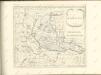

Stato Di Milano [Karte], in: Novus atlas absolutissimus, Bd. 5, S. 68.
1 Karte aus Atlas Janssonius Offizin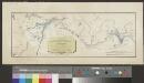
Carte de la nouvelle route depuis le Tyrol par le Col de Stilfs jusqu'a Milan
1 : 89500 1 Karte Hch Keller del ; Grimminger lith. Meyer, Zürich
L'Etat de Milan
1 : 440000 Mollova mapová sbírka Nolin, Jean-Baptiste Nolin, Jean Baptiste
Stato Di Milano [Karte], in: Le théâtre du monde, ou, Nouvel atlas contenant les chartes et descriptions de tous les païs de la terre, Bd. 3, S. 60.
1 Karte aus Atlas Blaeu, Willem Janszoon und Blaeu, Joan Blaeu, Willem Janszoon
Status Mediolanensis
1 : 460000 Mollova mapová sbírka Wolf, Jeremias Bodenehr, Gabriel
Stato Di Milano [Karte], in: Theatrum orbis terrarum, sive, Atlas novus, Bd. 3, S. 58.
1 Karte aus Atlas Blaeu, Joan Blaeu, Willem Janszoon
Stato Di Milano [Karte], in: Novus Atlas, das ist, Weltbeschreibung, Bd. 3, S. 68.
1 Karte aus Atlas Blaeu, Joan Blaeu, Willem Janszoon