Maps of Wartburgkreis

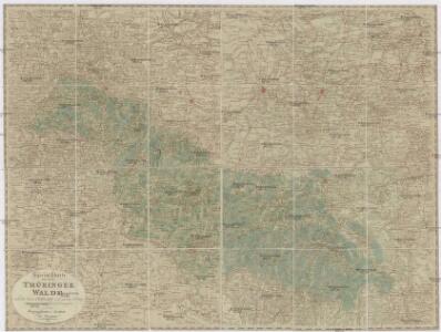
Special Charte von dem Thüringer Walde
Durynský les (Německo) von dem Geographischen Institute
Tvringiae Noviss. descript.
1 : 520000 Mollova mapová sbírka Mellinger, Johann Plantin, Christoph (officina)
Principatus Isenacensis
1 : 210000 Mollova mapová sbírka Homann, Johann Baptist Homann, Johann Baptista
Gross - Hherzogthum Sachsen - Weimar und Eisenach

Regierungsbezirk Erfurt Kreiseinteilung 1820
Preußen, Regierungsbezirk Erfurt Kunz, Andreas ; Johnen, Bettina ; Moeschl, Joachim
Principatus Isenacensis cum adjacentibus vicinorum statuum ditionibus exhibitus
1 : 190000 Durynsko (Německo) Homann, Johann Baptist J. B. Homann
Thuringer-Wald-Gebirges.
1 : 380000 Grassl, J. (Joseph)
Herzogtum Sachsen-Meiningen 1826 Verwaltungsstruktur
Sachsen-Meiningen Verwaltung Kunz, Andreas ; Moeschl, Joachim Robert
Carte pour Servir de Suite à la Partie Meridionale du Landgraviat de Hesse-Cassel avec les pays voisins de la Thüringe
1 : 200000 Mollova mapová sbírka Brönner, Heinrich Ludwig Broenner, Heinrich Ludwig
Herzogtum Sachsen-Meiningen 1829 Verwaltungsstruktur
Sachsen-Meiningen Verwaltung Kunz, Andreas ; Moeschl, Joachim Robert

Karte des Thüringer-Wald-Gebirges zugleich special Karte des Herzogthums Sachs-Meiningen-Hildburghausen des Fürstenthums Coburg und der Schwarzburgischen Fürstenthümer Rudolstadt und Sondershausen
Grosser Hand-Atlas über alle Theile der Erde in 170 Karten Meyer, J. Verlag des Bibliographischen Instituts
Großherzogtum Sachsen-Weimar-Eisenach 1820 Verwaltungsstruktur
Sachsen-Weimar-Eisenach Verwaltung Kunz, Andreas ; Moeschl, Joachim Robert
Geographische Charte
1 : 300000 Mollova mapová sbírka Zollmann, Friedrich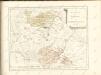

Thvringia
1 Karte : Kupferdruck ; 33 x 40 cm Mercator; Hondius sumptibus Henrici Hondÿ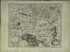
Thvringia
1 Karte : Kupferdruck ; 33 x 40 cm Mercator s.n.
Herzogtum Sachsen-Coburg und Gotha 1830 Verwaltungsstruktur
Sachsen-Coburg-Gotha Verwaltung Kunz, Andreas ; Moeschl, Joachim Robert
Herzogtum Sachsen-Coburg und Gotha 1826 Verwaltungsstruktur
Sachsen-Coburg-Gotha Verwaltung Kunz, Andreas ; Moeschl, Joachim Robert
Herzogtum Sachsen-Coburg und Gotha 1834 Verwaltungsstruktur
Sachsen-Coburg-Gotha Verwaltung Kunz, Andreas ; Moeschl, Joachim Robert
Thvringia Landgraviatvs
1 : 420000 Mollova mapová sbírka Merian, Matthaeus Merian, Matthäus
Hennebergensis Ditionis. vera delineatio [Karte], in: Theatrum orbis terrarum, S. 133.
1 Karte aus Atlas Ortelius, Abraham
Zu den Operationen der Generale Syburg, Schenkendorf und Linden gegen die Reichsarmee, vom 15ten Februar bis zum 5ten April 1761

Hennebergensis Ditionis. vera delineatio [Karte], in: Theatrum orbis terrarum, S. 225.
1 Karte aus Atlas Ortelius, Abraham Vrients, Jan Baptista
Herzogtum Sachsen-Meiningen 1820 Verwaltungsstruktur
Sachsen-Meiningen Verwaltung Kunz, Andreas ; Moeschl, Joachim Robert
[Neueste Karte vom Herzogth: Gotha und angränzend: Ländern]
Grosser Hand-Atlas über alle Theile der Erde in 170 Karten Meyer, J. Verlag des Bibliographischen Instituts
Geognostische Uebersichtskarte des Thüringer Waldes
1 : 100000 Beyschlag, Franz ; Pütz, M. Simon Schropp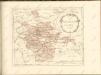

Erfurt 87, uit: Special-Karte von Mittel-Europa / nach amtlichen Quellen bearbeitet von W. Liebenow
1 : 300000 titelvariant: W. Liebenow's Mittel-Europa; Annotatie: Titel boven de bladen: W. Liebenow's Mittel-Europa Johannes Wilhelm Liebenow 1822-1897 Frankfurt a. M. : Ludwig Ravenstein