Maps of KwaZulu-Natal

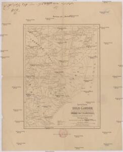
Special-Karte des Zulu-Landes, der angrenz. britischen Colonial-Territorien Natal und Transvaal u. d. portugiesischen Besitzungen an der Delagoa Bay
1 : 1600000 Mpumalanga (Jihoafrická republika) W. Nagel
Natal And Kaffraria.
1 : 2640000 Tallis, J. & F.
Ba-Souto mission area based on information provided by the missionaries of the Society of Evangelical Missions of Paris.
175. Republic of South Africa. Capetown. The World Atlas.
1 : 1250000 USSR (Union of Soviet Socialist Republics).
Übersichts-Karte Marianhill und seine Stationes
1 : 796000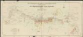
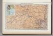
General map of the witwatersrand gold fields. The consolidated Gold Fields of south Africa, Limited
1 : 60000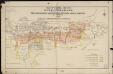
Plan of Central section of the Witwatersrand. shewing properties in wich the consolidated gold fields of South Africa, Limited are interested
1 : 30000 (Afrique du Sud) Survey Department Londres : Waterlow & Sons
Carte du théatre de la guerre Sud Africaine
1 : 6000000 Favre, Camille Schlumpf
Cape Province, Transvaal, &c. - eastern section.
1 : 2500000 John Bartholomew and Son
Recto, uit: W. & A. K. Johnston's pictorial bird's-eye map of the Transvaal, Orange Free State, Natal, &c
1 : 1175000 titelvariant: Johnston's pictorial bird's-eye map of the Transvaal, Orange Free State, Natal, &c; Annotatie: Omslagtitel: Johnston's pictorial bird's-eye map of the Transvaal, Orange Free State, Natal, &c Edinburgh [etc.] : W. & A.K. Johnston
Südafrikanische Republik (Transvaal) und Oranje-Freistaat
1 : 5000000 G. Freytag & Berndt
Union of South Africa Special Map Accompanying Richmond's South African All Mining Year Book (Sheet 2)
Union of South Africa. Special map accompanying Richmond's South African All Mining Year Book illustrating the location of Mines, Quarries and Works. Johannesburg : Hortors
Südafrikanische (Transvaal-) Republik, Oranje-Freistaat und angrenzende Gebiete
1 : 3000000 Afrika jižní Carl Flemming
Zuid-Afrikaansche Republiek, Oranje-Vrijstaat, Natal, enz
1 : 2500000 titelvariant: Kaart der Zuid-Afrikaansche Republiek, (Transvaal) Oranje-Vrijstaat, Natal enz; Annotatie: Omslagtitel: Kaart der Zuid-Afrikaansche Republiek, (Transvaal) Oranje-Vrijstaat, Natal enz. (met de spoorwegen); Annotatie geografische gegevens: Legenda Amsterdam : Seyffardt's Boekhandel / ([S.l. : Mij. voor photolithogr & zincographie, procédé mr. F.J. Asser])
Partie, la Caffrerie. Afrique 52.
1 : 1641836 Vandermaelen, Philippe, 1795-1869
Kaart van de Zuid-Afrikaansche Republiek (Transvaal)
1 : 1500000 Den Haag : J. Smulders
Specialkarte der Südafrikanischen- (Transvaal) Republik

W. H. Smith & Son's War map of the Transvaal and adjoining countries in South Africa
1 : 2700000 J. Bartholomew London : Smith
Oorlogskaart van Zuid-Afrika 1899-1900 / bew. te Pretoria naar officieele gegevens
1 : 1250000 Rotterdam : Nijgh & Van Ditmar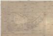
Cape of Good Hope
1 : 1909000 Mys dobré naděje (Jihoafrická republika) Arrowsmith, John J. Arrowsmith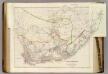
Cape of Good Hope.
1 : 2407680 Arrowsmith, John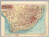
Republic of South Africa. Pergamon World Atlas.
1 : 5000000 Polish Army Topography Service
Sud-Africa.
1 : 4700000 Flemming, Carl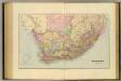
South Africa.
1 : 2914560 Stanford, Edward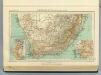
120. Colonia del Capo.
1 : 5000000 Touring club italiano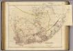
Cape of Good Hope.
1 : 2350000 Arrowsmith, John
Southern Africa.
1 : 3100000 Hall, S. (Sidney)
Zuidelijkste gedeelte van Afrika of het land der Hottentotten : volgens de nieuwste waarneminghe opgesteld
1 : 15000000 Te Amsterdam : bij de Wed. van Esveldt en Holtrop
South Africa, Cape Colony.
1 : 7180000 Higgins, W.M.