Maps of Palestine

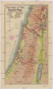
Palestýna
1 : 566000 Palestina
Cesta Israelitů z Egypta a cesty sv. Pavla

Palaestina
1 : 170000 Palestina
Palestine or Canaan
1 : 1
Palestine and the Holy Land.
1 : 930000 Schonberg & Co.
Iudaea seu Palaestina ob sacratißima redemtoris vestigia hodie dicta Terra Sancta
1 : 3100000 Kanaán Homann, Johann Baptist Sanson, Guillaume á Ioh. Baptista Homanno
Terra Sancta, sive promissionis, olim Palestina
1 : 960000 Izrael Wit, Frederick de per Fredericum de Wit
Palestina: gráfico de la vida de Jesús y año litúrgico
1 Mapa. La data és la que figura en el Nihil Obstat del censor. Datació aproximada Font, Lamberto
Palaestina za času P. Ježíše
Izrael
Palestine
1 : 200000 Palestina Survey of Egypt
Der Lebensweg Jesu
Izrael Harwerth, Willi Johannes Stauda
Palästina
1 : 250000 Palestina Preußische Landesaufnahme
Palestine campaign (1921)
Palestine campaign: Situation at 1800 on 1st Nov. 1917 (24 hours after the capture of Beersheba), GSGS 2965. Great Britain. General Staff. Geographical Section. [London] : [GSGS, War Office]
(Sheet 4). Western Palestine Illustrating The New Testament, also The Talmud and Josephus.
1 : 168960 Kitchener, H.R. (Horatio Herbert)
(Sheet 3). Western Palestine Natural Drainage and the Mountain Ranges.
1 : 168960 Kitchener, H.R. (Horatio Herbert)
44 Jerusalem, Jaffa.
1 : 100000 Jacotin, Pierre, 1765-1827
43 Gaza.
1 : 100000 Jacotin, Pierre, 1765-1827
Levés en Galilée faisant suit à la Carte du Liban de l'Etat-Major Français : exécutés en 1870 / par M.M. Mieulet et Derrien
1 : 100000 titelvariant: Levés en Galilée; Annotatie: Met verklaring van Arabische termen H. Mieulet; Isidore-Antoine-Michel Derrien 1839-1904 [S.l. : Lemercier]
(Sheet 2). Western Palestine ... Reduced from the One-Inch Map. Scale 3/8 inch to one mile or 1:168,960.
1 : 168960 Kitchener, H.R. (Horatio Herbert)
De reeden van St. Juan de Acari met het land daer bezuijden en benoorden geleegen aen de kust van Soria of Sirien
Israel Gerard van Keulen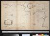
De reede van St. Jan de Acari en Kaijfa met t Land van Sidon of Saita
Israel Gerard van Keulen
46 Cesaree.
1 : 100000 Jacotin, Pierre, 1765-1827
Sheet XVI. Palestine Exploration Map.
1 : 63360 Kitchener, H.R. (Horatio Herbert)
Sheet XVIII. Palestine Exploration Map.
1 : 63360 Kitchener, H.R. (Horatio Herbert)
Sheet VIII. Palestine Exploration Map.
1 : 63360 Kitchener, H.R. (Horatio Herbert)
Sheet XXIV. Palestine Exploration Map.
1 : 63360 Kitchener, H.R. (Horatio Herbert)
Sheet XV. Palestine Exploration Map.
1 : 63360 Kitchener, H.R. (Horatio Herbert)
The Land Of Moriah Or Jerusalem and the Adjacent Country.
1 : 76000 Finley, Anthony
Gaza, Palestine
[Palestine]. Great Britain. Army. Royal Engineers. Field Survey Coy., 7th. [S.l.] : printed by Survey of Egypt