Maps of Island Of Newfoundland

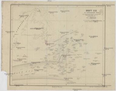
Drift Eis im Nordatlantischen Ocean
Atlantský oceán Redfield, W. C. D. Reimer
Ice Chart, Grand Banks Region, March, April.
U.S. Navy
Ice Chart, Grand Banks Region, May, June.
U.S. Navy
Ice Chart, Grand Banks Region, September, October.
U.S. Navy
Ice Chart, Grand Banks Region, November, December.
U.S. Navy
Ice Chart, Grand Banks Region, July, August.
U.S. Navy
Chart From Cape Cod To Belle Isle.
1 : 1280000 Eldridge, George
A Chart Of The Banks Of Newfoundland
1 : 2200000 Jefferys, Thomas
Newfoundland Nova Scotia And New Brunswick.
1 : 2787840 Burr, David H., 1803-1875
Grand Banks Region, Index Chart for Ice Data Tables
U.S. Navy
Ice Chart, Grand Banks Region, February.
U.S. Navy
Newfoundland, Nova Scotia, New Brunswick, Cape Breton and Prince Edward Islands.
1 : 5800000 Schonberg & Co.
Newfoundland, Nova Scotia, And New Brunswick.
1 : 5800000 Greenleaf, Jeremiah
Newfoundland Nova Scotia And New Brunswick.
1 : 5680000 Greenleaf, Jeremiah
Ice Chart, Grand Banks Region, January, February.
U.S. Navy
New Found Land, St. Laurence Bay, Acadia, New Scotland.
1 : 4800000 Moll, Herman, d. 1732
Le Isole di Terra Nuova e Capo Breton Di Nuova Projezione.
1 : 2100000 Zatta, Antonio
Map of Newfoundland.
1 : 3900000 Morse, Jedidiah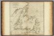
A General Chart Of The Island Of Newfoundland.
1 : 1280000 Jefferys, Thomas
Newfoundland.
1 : 1204000 Rand McNally and Company
A Map of the British Empire in America. (Sheet 8).
1 : 2000000 Popple, Henry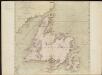
A general chart of the island of Newfoundland with the rocks & soundings
1 : 1280000
Newfoundland.
1 : 1584000 Stanford, Edward
Nova Scotia And Newfoundland.
1 : 4300000 Tallis, J. & F.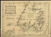
A new map of the only useful and frequented part of New Found Land
1 : 2800000
Limits under fishery treaties, 1818 and 1888
1 : 2800000 Roberts, A. C., cartographe 18..-.... [Washington, D.C.] : Hydrographic Office, Navy Department, USA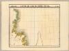
Partie, Ile de Terre Neuve. Amer. Sep. 37.
1 : 1641836 Vandermaelen, Philippe, 1795-1869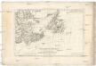
Isle et banc de Terre-Neuve, Isle Royale et Isle St. Jean, avec l'Acadie ou la Nouvelle Ecosse
1 : 5560000 Akádie Bonne, Rigobert André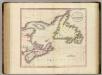
Nova Scotia, Newfoundland, &c.
1 : 2350000 Cary, John, ca. 1754-1835