Maps of South America

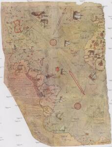
Bu harita, büyük Türk denizcisi Piri reis tarasindam 1513 tarihinde yapilmis olan ve Topkapi Müzesinde bulunan aslindan alinarak basilmistir
Atlantský oceán-oblast Devlet Basimevi
America [Karte], in: Gerardi Mercatoris Atlas, sive, Cosmographicae meditationes de fabrica mundi et fabricati figura, S. 547.
1 Karte aus Atlas Mercator, Gerhard Montanus, Petrus
South America.
from A new sett of maps both of antient and present geography : wherein not only the latitude and longitude of many places are corrected according to the latest observations, but also the most remarkable differences of antient and present geography may be quickly discern'd by a bare inspection or comparing of correspondent maps, which seems to be the most natural and easy method to lead young students (for whose use the work is principally intended) unto a competent knowledge of the geographical science : together with a geographical treatise particularly adapted to the use and design of these maps / by Edward Wells, M.A. and student of Christ-Church, Oxon.
IV. Isothermal chart of the Atlantic Ocean for March and September
Maury, Matthew Fontaine
Map of South America, showing its political divisions ; Map showing the proposed Atrato-inter-oceanic canalroutes, for connecting the Atlantic and Pacific oceans [inset].
from New general atlas.
A generall chart from ENGLAND to cape Bona Espranca with the coast of BRASILE
from The sea-atlas : containing an hydrographical description of most of the sea-coasts of the known parts of the world.
(Facsimile) America by Martyr.
Martyr, Peter
Atlantic Ocean.
1 : 45000000 Lizars, W. H. (William Home)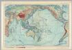
Pacific and Indian Ocean. Pergamon World Atlas.
1 : 50000000 Polish Army Topography Service
Map of Brazil, Bolivia, Paraguay, and Uruguay ; Harbor of Rio Janeiro [inset]; Harbor of Bahia [inset]; Map of Chili ; Island of Juan Fernandez [inset].
from New general atlas.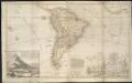
This map of South America, according to the newest and most exact observations ...
1 : 17500000
Ethnographische Karte von Süd-Amerika
Zweiter Band, enthaltend in vier Abtheilungen die Vertheilung der Organismen: 5. Pflanzen-Geographie, 6. Thier-Geographie, 7. Anthropographie, 8. Ethnographie Humboldt, Alexander von Verlag von Justus Perthes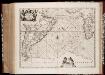
Mar di Æthiopia vulgo Oceanus Æthiopicus
1 : 22500000 Annotatie: Zeekaart; Origineel is Blad 202 in atlas factice; Annotatie geografische gegevens: Met schaalstok: Mill. Germanica Communia [Amstelodami : apud Ioannem Ianssonium]
Mar Di Aethiopia Vulgo Oceanus Aethiopicus. [Karte], in: Novus atlas absolutissimus, Bd. 9, S. 79.
1 Karte aus Atlas Janssonius Offizin
South America
Este mapa, sin fecha y sin autor conocido, probablemente sea de mediados del siglo XVIII. La representación de Islas Malvinas a partir del Estrecho de Falkland, como era común en la primera mitad del siglo XVIII, es un indicio en ese sentido. En enero de 1690 el inglés John Strong navegó entre las dos islas principales y llamó al paso "Falkland Channel" en honor a su mecenas el Vizconde de Falkland que como había financiado la expedición. La cartografía británica adoptaría en el siglo XVIII el nombre del canal, para designar a todo el grupo de islas, que reclamaría para Inglaterra, en contra de España. En 1740 hubo un enfrentamiento naval entre las fuerzas británicas y españolas por las islas, sin un claro vencedor. Las tensiones entre los dos imperios continuaría a lo largo del siglo XVIII.
[Süd-Amerika]
Atlas der Geologie Zittel, K.v. ; Berghaus, Hermann Justus Perthes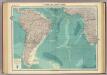
South Atlantic Ocean.
1 : 25000000 John Bartholomew & Co.
Mar Di Aethiopia Vulgo Oveanus Aethiopicus. [Karte], in: Het vijfde Deel Des Grooten Atlas : Vervatende De Water-Weereld, S. 69.
1 Karte aus Atlas Jansson, Jan Jansson, Jan
A new & exact map of the coast, countries and islands within ye limits of ye South Sea Company, from ye river Aranoca to Terra del Fuego, and from thence through ye South Sea, to ye north part of California &c. with a view of the general and coasting ...
1 : 32000000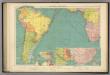
S. Atlantic Ocean.
1 : 20000000 Philip, George
A map of the states of Virginia, North Carolina, South Carolina and Georgia : comprehending the Spanish provinces of east and west Florida : exhibiting the boundaries as fixed by the late treaty of peace between the United States and the Spanish dominion
from Charts and maps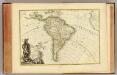
L'Amerique Meridionale.
1 : 31000000 Janvier, Jean
Carte Physique de L'Amérique du Sud
1 : 2000000 Description géographique et statistique de la Confédération Argentine Martin de Moussy, Victor Librairie de Firmin Didot frères, fils et Cie
149-50. America Meridionale fisica.
1 : 20000000 Touring club italiano
Süd America
Stieler's Hand-Atlas Stieler, Adolf bei Justus Perthes
218-219. South America, Physical. The World Atlas.
1 : 20000000 USSR (Union of Soviet Socialist Republics).
South America.
1 : 25344000 Carey, Mathew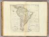
Map Of South America.
1 : 25344000 Carey, Mathew
South America.
1 : 26000000 Carey, Mathew