Maps of Carpathian Mountains

[Ungarn Siebenbürgen]
Maďarsko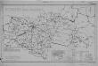
Hungary Railways (1944)
Hungary 1943 : Railways, MDR Misc 8021. Includes detail in territories annexed by Hungary from Czechoslovakia, Roumania and Yugoslavia. Great Britain. Army. Royal Engineers. Field Survey Company, 512th. [Cairo] : [Survey Directorate, Middle East]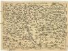
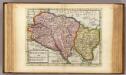
Regni Hvngariae
1 : 4000000 Uhersko
[Uhry]
1 : 914000 Maďarsko
Novissima regni Hungariae potamographica et telluris productorum tabula
1 : 991000 Maďarsko Junker, Christoph Joh. Matth. Korabinsky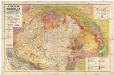
A Magyar birodalom és a szomszédos országok határos területeinek földtani térképe
1 : 900000 Maďarsko Lóczy, Lajos Papp, Károly Magyar földrajzi társaság
Ungarn, Siebenburgen, Slavonien, Kroatien.
1 : 1850000 Stieler, Adolf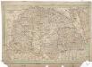
Charte von den kaiserlich Oesterreichischen Ungarischen Ländern
1 : 1240000 Maďarsko Streit, Friedrich Wilhelm im Verlage des Geograph. Instituts
Hvngariae descriptio / Wolfgango Lazio avct
1 : 1400000 1 Karte : Kupferdruck ; 32 x 49 cm Lazius, Wolfgang [Verlag nicht ermittelbar]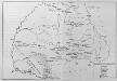
Siebenbürgen und Nachbargebiete
Siebenbürgen, Banat
Allgemeine Postkarte von Ober Ungarn und Siebenbürgen
Chorvatsko Benedict, Anton im von Reillyschen Landkarten und Kunstwerke Verschleiss Komptoir
Hungary and Transilvania
1 : 2800000 Mollova mapová sbírka Moll, Herman Moll, Hermann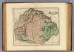
Hungary, Transilvania &c.
1 : 1470000 Lizars, Daniel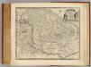
Hungary, Transilvania.
1 : 1650000 Bowen, Emanuel
Hungary and Transilvania.
1 : 2800000 Moll, Herman, d. 1732
Ungarn und ein Theil von Siebenbürgen
Hand-Atlas über alle Theile der Erde nach dem neuesten Zustande und über das Weltgebäude Stieler, Adolf bei Justus Perthes
Ungarn und ein Theil von Siebenbürgen
Stieler's Hand-Atlas Stieler, Adolf bei Justus Perthes
Novissima et Accuratissima Hungariae Tabula In suas partes divisa J.U.M.
1 : 1700000 Mollova mapová sbírka
Austrian Empire 2.
1 : 1774080 Letts, Son & Co.
Ungarn und ein Theil von Siebenbürgen
Hand-Atlas über alle Theile der Erde nach dem neuesten Zustande und über das Weltgebäude Stieler, Adolf bei Justus Perthes
Hvngariae descriptio
1 : 3400000 Uhersko Lazius, Wolfgang Ortelius, Abraham A. Ortelius
Principatus Transilvaniae in suas quasque nationes earumque sedes et regiones
1 : 705000 Rumunsko Homann, Johann Baptist J. B. Homann
Principatus Transilvaniae in suas quasque nationes earumque sedes et regiones
1 : 688000 Sedmihradsko (Rumunsko) Homann, Johann Baptist operá Ioh. Baptistae Homanni
Hvngaria
1 Karte : Kupferdruck ; 35 x 43 cm Mercator; Hondius Henricus Hondius
Hvngaria
1 Karte : Kupferdruck ; 35 x 43 cm Mercator s.n.
Plan des Hoch Geföls Korpsona
Mollova mapová sbírka Geyer
"Erdély" térképe
1 : 900000 Sedmihradsko (Rumunsko) Manó, Kogutowicz Magyar Földrajzi Intézet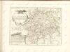
![[Ungarn Siebenbürgen]](https://images-2.georeferencer.com/images/iiif/675806058984/full/,300/0/native.jpg)

