Maps of Israel

Palaestina
1 : 640000 Palestina Reichard, Christian Gottlieb Campius, D. a D. Campio
Palästina
Plastischer Schul-Atlas über alle Theile der Erde : in 24 Karten Woldermann, G Verlag von P. Eckerlein
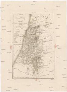
Palestine
1 : 1000000 Colton, G.W.
Palaestina.
1 : 1950000 Fenner, Rest.
[Kaart], uit: Neue Handkarte von Palästina / bearb. von Hans Fischer und H. Guthe
1 : 700000 Fischer, Hans (fl. 1910); Guthe, Hermann Leipzig : Wagner & Debes
Palestina

Terre de Canaan á present la Palestine
1 : 1100000 Kanaán
Palestine sous la domination romaine.
1 : 800000 Picquet, C.
Palästina / bearb. von Hans Fischer & H. Guthe
1 : 700000 Fischer, Hans (fl. 1910); Guthe, Hermann Leipzig : Wagner & Debes [etc.]
Palestine; Jerusalem.
1 : 660000 John Bartholomew & Co.
Turkey in Asia (Biblical Regions) The Holy Land And Its Borders.
1 : 696960 Fullarton, A. & Co.
Palestine (with) Arabia Petraea.
1 : 1013760 Colton, G.W.

Karte von Palästina
1 : 515000 Jeruzalém Velde, Charles William Meredith van de Justus Perthes
Palästina zur Zeit Jesu Christi und der Apostel
Palestina
Palaestina: ex veteris aevi monumentis ac recentiorum observationibus
1 : 450000 illustravit Marinus Didericus de Bruyn sculpsit Georgius Mayr Amstelodami : De Grebber
Palestine sous la Domination Romaine.
Levasseur, E.
Palestine, Royaume des Israelites, Les Douze Tribus.
Malte-Brun, Conrad, 1775-1826
Mapat erets Yisrael
1 : 673000 Izrael Blücher, Ephraim J.
Palaestina za času Krista Pána
1 : 1030000 Izrael Fáborský, Jan B. Dědictví sv. Cyrilla a Methodia
Palaestina za času Krista Pána
1 : 1030000 Izrael Fáborský, Jan B. Dědictví sv. Cyrilla a Methodia
Palästina oder Kanaan zur Zeit des Israelitischen Reiches
Palestina Kiepert, Heinrich Arnd Geographisches Institut
La Judee, Canaan.
1 : 850000 Robert de Vaugondy, Gilles, 1688-1766
Palestine (ancient).
1 : 1320000 Migeon, J.
Carta della Palestina sotto il dominio de'Romani
1 : 680000 Marzolla, Benedetto [Verlag nicht ermittelbar]
Karte des Heiligen Landes
1 : 310000 Izrael Möller, Arnold Wilhelm A.W. Möller
Palestine sous la domination romaine.
1 : 800000 Brue, Adrien Hubert, 1786-1832
Kaart van 't land Kanaan / naar de beste waarnemingen tot verstand van Num. XXI:14-31 ontworpen door R. Schutte ; J. van Jagen sculps. 1766
1 : 800000 Annotatie: Waarschijnlijk blad uit zakatlas Schutte, Rutger; Jagen, J. van Te Amsterdam : by J. Loveringh