Maps of Pontic Steppe
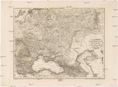
Dacia or., Sarmatia, Caucasus, Scythia int. Imaum
1 : 800000 Dácie Reichard, Christian Gottlieb Campius, D. a D. Campio
Russland in den Jahren von 900 bis 966
1 : 15000000 Russland / Europäischer Teil
Dacia Or., Sarmatia, Caucasus, Scythia Int. Imaum / J.E. Knittel sculps
1 : 5100000 1 Karte : Kupferdruck ; 45 x 58 cm Campe, Friedrich Campius
Verbreitung der Slaven um 1900
Osteuropa Slawen Anton, J.
Národopisná mapa Slovanstva

Standorte der höheren Kommandos in Europa und Kaukasus
Russland Russland / Europäischer Teil Kaukasus Militär
[Secunda Asie tabula] [Karte], in: Clavdii Ptholomei Viri Alexandrini Cosmographie, S. 167.
1 Karte aus Atlas Nicolaus Germanus [und Ptolemaeus, Claudius]
Russland in den Jahren von 966 bis 1114
1 : 15000000 Russland / Europäischer Teil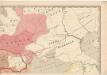
Evropa raného středověku: do konce VI. století po Kr.
Kašpar, Jan
Secunda Asie Tabula [Karte], in: [Clavdii Ptholomei Cosmographi ...], S. 302.
1 Karte aus Atlas Nicolaus Germanus [und Ptolemaeus, Claudius]
Uebersicht über die Stabsquartiere der russischen Armee
Russland Militär
Tabula Asiae II. [Karte], in: Geographia universalis vetus et nova complectens Claudii Ptolemaei Alexandrini enarrationis libros VIII, S. 269.
1 Karte aus Atlas Münster, Sebastian [und Ptolemaeus, Claudius]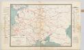
Spoorwegkaart van Rusland / naar de nieuwste bronnen vervaardigd door J. Pik
1 : 2500000 Annotatie: Met informatie over Russische spoorwegmaatschappijen en over het Russische geld; Annotatie geografische gegevens: Met drie maatstokken: Duitsche mijlen, Kilometers en Wersten J. Pik Groningen : De Financier
Russia in Europe.
1 : 8400000 Sharpe, J.
Verbreitung der Slaven um 1400
Osteuropa Slawen Anton, J.
Das europaeische Russland
1 : 6588000 Rusko západní Weiland, Karl Ferdinand Geograph. Institut
[Neuer Atlas der ganzen Erde nach den neuesten Bestimmungen ... : XXII.] Charte von dem Europaeisch-Russischen Reiche
Entworfen u. gezeichnet von Dr. F.W. Streit H. Leutemann sc. Leipzig : J.C. Hinrichssche Buchhandlung
Das Europaeische Russland
Russland / Europäischer Teil
Ruszland, Regenmenge u. Januar-Jsothermen
Russland / Europäischer Teil Pflanzenbau, Klima
Map illustrating ancient Russian history
Russland Kiewer Reich Philip, George ; Philip, [Sohn v. G.]
Russland von der Zerstörung Kiews durch Batu, 1240, bis zum Übergang des Grossfürstenthums nach Moskau
1 : 15000000 Russland
Karta želěznych dorog Rossijskoj imperiji
1 : 1200000 Moskva-oblast (Rusko) izdanije Kartografičeskago zavedenija A. Il'jina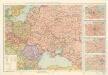
Soubor zájezdových map – Svaz Sovětských Socialistických Republik

Des europäischen Russlands südlicher Theil
Allgemeiner Atlas [Walch, Johannes] im Verlag bei Johannes Walch
Russland nach seinen kirchlichen Verhältnissen bis zum XVI. Jahrhundert
1 : 15000000 Russland Kirchengeschichte
Composite: Sheets 1 - 16 Kriegsstrassen Karte eines Theiles von Russland
1 : 1400000 Schubert, Friedrich Theodor
20. Nord u. Ost-Europa im Jahre 1310
Nordeuropa, Osteuropa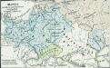
Slawen nördlich der Donau 850 bis 900
1 : 24000000 Ostmitteleuropa Slawen
Charte von dem europaeisch Russischen Reiche
1 : 7400000 Rusko západní Kipferling, Karl Joseph J. Riedl's Kunsthandlung
Charte von dem europaeisch Russischen Reiche
1 : 7400000 Rusko západní Kipferling, Karl Joseph J. Riedl's Kunsthandlung