Maps of powiat sulęciński

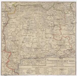
Der Sternbergsche Creis
1 : 292000 Sotzmann, Daniel Friedrich

91. Frankfurt a/O., uit: Topographische Uebersichtskarte des Deutschen Reiches / herausgegeben v. d. Kartogr. Abt. d. Königl. Preuß. Landesaufnahme
1 : 200000 titelvariant: Topogr. Übersichtskarte des Deutschen Reiches; Annotatie: Titel boven bladen ook: Topogr. Übersichtskarte des Deutschen Reiches; Annotatie geografische gegevens: Op elk blad twee maatstokken: 10 Kilometer = 5,5 cm; 1 geogr. Meile = 3,6 cm; Legenda onder op elk blad Königlich Preußische Landesaufnahme. Kartographische Abtheilung [S.l : Königlich Preußische Landesaufnahme, Kartographische Abtheilung]
297.1 Zielenzig.
1 : 100000 Reichsamt fur Landesaufnahme
Composite: 297 Zielenzig.
1 : 100000 Reichsamt fur Landesaufnahme
297. Zielenzig.
1 : 100000 Reichsamt fur Landesaufnahme
Composite: 321. Krossen a. d. Oder.
1 : 100000 Reichsamt fur Landesaufnahme
272.1. Landsberg a. d. W.
1 : 100000 Reichsamt fur Landesaufnahme
Plan von der Battaille bey Cunersdorf am 12ten August 1759

Okrestnosti Kunnersdorfa
Polen Kunersdorf Siebenjähriger Krieg
Meßtischblatt 2123 : Skampe, 1896
1 : 250000 Skampe. - Aufn. 1894. - 1:25000. - [Berlin]: Reichsamt für Landesaufnahme, 1896. - 1 Kt.
Meßtischblatt 2122 : Beutnitz, 1933
1 : 250000 Beutnitz. - Hrsg. 1896, bericht. 1933. - 1:25000. - [Berlin]: Reichsamt für Landesaufnahme, 1933. - 1 Kt.
Meßtischblatt 2122 : Beutnitz, 1896
1 : 250000 Beutnitz. - Aufn. 1894. - 1:25000. - [Berlin]: Reichsamt für Landesaufnahme, 1896. - 1 Kt.
Meßtischblatt 2121 = 3856 : Baudach, 1938
1 : 250000 Baudach. - Hrsg. 1896, bericht. 1933, red. Änd. 1938. - 1:25000. - [Berlin]: Reichsamt für Landesaufnahme, 1938. - 1 Kt.
Meßtischblatt 2121 : Baudach, 1929
1 : 250000 Baudach. - Hrsg. 1896, bericht. 1925, einz. Nachtr. 1929. - 1:25000. - [Berlin]: Reichsamt für Landesaufnahme, 1929. - 1 Kt.
Meßtischblatt 2121 : Baudach, 1909
1 : 250000 Baudach. - Aufn. 1894, hrsg. 1896, einzelne Nachtr.1909. - 1:25000. - [Berlin]: Reichsamt für Landesaufnahme, 1909. - 1 Kt.
Meßtischblatt 2121 : Baudach, 1896
1 : 250000 Baudach. - Aufn. 1894, hrsg. 1896. - 1:25000. - [Berlin]: Reichsamt für Landesaufnahme, 1896. - 1 Kt.
Meßtischblatt 2120 : Tammendorf, 1933
1 : 250000 Tammendorf. - Aufn. 1894, bericht. 1933. - 1:25000. - [Berlin]: Reichsamt für Landesaufnahme, 1933. - 1 Kt.
Meßtischblatt 2120 : Tammendorf, 1896
1 : 250000 Tammendorf. - Aufn. 1894. - 1:25000. - [Berlin]: Reichsamt für Landesaufnahme, 1896. - 1 Kt.
Meßtischblatt 3854 : Fürstenberg an der Oder, 1936
1 : 250000 Fürstenberg an der Oder. - Hrsg. 1896, bericht. 1934. - 1:25000. - [Berlin]: Reichsamt für Landesaufnahme, 1936. - 1 Kt.
Meßtischblatt 2119 : Fürstenberg (An der Oder), 1923
1 : 250000 Fürstenberg (An der Oder). - Aufn. 1894, bericht. 1923. - 1:25000. - [Berlin]: Reichsamt für Landesaufnahme, 1923. - 1 Kt.
Meßtischblatt 2119 : Fürstenberg (An der Oder), 1917
1 : 250000 Fürstenberg (An der Oder). - Aufn. 1894, hrsg. 1896, einz. Nachtr. 1907. - 1:25000. - [Berlin]: Reichsamt für Landesaufnahme, 1907. - 1 Kt.
Meßtischblatt 3758 : Mühlbock, 1944
1 : 250000 Mühlbock. - Aufn. 1894, hrsg. 1896, bericht. 1944. - 1:25000. - [Berlin]: Reichsamt für Landesaufnahme, 1944. - 1 Kt.
Meßtischblatt 3757 : Topper, 1933
1 : 250000 Topper. - Hrsg. 1896, bericht. 1933. - 1:25000. - [Berlin]: Reichsamt für Landesaufnahme, 1933. - 1 Kt.
Meßtischblatt 2054 : Topper, 1911
1 : 250000 Topper. - Aufn. 1894, hrsg. 1896, einz. Nachtr. 1911. - 1:25000. - [Berlin]: Reichsamt für Landesaufnahme, 1911. - 1 Kt.
Meßtischblatt 2053 : Leichholz, 1935
1 : 250000 Leichholz. - Hrsg. 1896, bericht. 1933, Sonderdr. 1935. - 1:25000. - [Berlin]: Reichsamt für Landesaufnahme, 1935. - 1 Kt.
Meßtischblatt 2052, Neue Nr. 3755 : Gr. Gandern, 1933
1 : 250000 Gr. Gandern. - Hrsg. 1896, bericht. 1933. - 1:25000. - [Berlin]: Reichsamt für Landesaufnahme, 1933. - 1 Kt.
Meßtischblatt 2052, Neue Nr. 3755 : Gr. Gandern, 1923
1 : 250000 Gr. Gandern. - Aufn. 1894, bericht. 1923. - 1:25000. - [Berlin]: Reichsamt für Landesaufnahme, 1923. - 1 Kt.
Meßtischblatt 2052, Neue Nr. 3755 : Gr. Gandern, 1896
1 : 250000 Gr. Gandern. - Aufn. 1894. - 1:25000. - [Berlin]: Königl. Preuss. Landesaufnahme, 1896. - 1 Kt.
Meßtischblatt 2051, Neue Nr. 3754 Aurith, 1923
1 : 250000 Aurith. - Aufn. 1894, bericht. 1923. - 1:25000. - [Berlin]: Reichsamt für Landesaufnahme, 1923. - 1 Kt.