Maps of powiat drawski
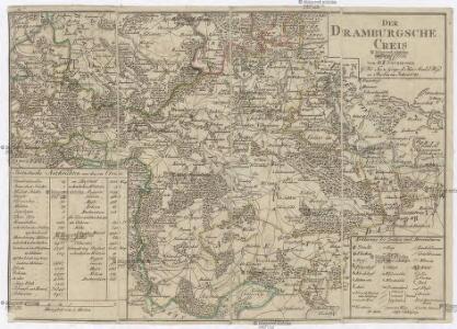
Der Dramburgsche Creis
1 : 296000 Drawsko Pomorskie (Polsko) Sotzmann, Daniel Friedrich
158. Tempelburg. (Germany)
1 : 100000 Reichsamt fur Landesaufnahme
Composite: 158. Tempelburg. (Germany)
1 : 100000 Reichsamt fur Landesaufnahme
Composite: 157. Labes. (Germany)
1 : 100000 Reichsamt fur Landesaufnahme
157. Labes. (Germany)
1 : 100000 Reichsamt fur Landesaufnahme
Composite: 190. Callies. (Germany)
1 : 100000 Reichsamt fur Landesaufnahme
190. Callies. (Germany)
1 : 100000 Reichsamt fur Landesaufnahme
Composite: 189. Norenberg. (Germany)
1 : 100000 Reichsamt fur Landesaufnahme
189. Norenberg. (Germany)
1 : 100000 Reichsamt fur Landesaufnahme
159. Neustettin. (Germany)
1 : 100000 Reichsamt fur Landesaufnahme
Composite: 191. Deutsch-Krone. (Germany)
1 : 100000 Reichsamt fur Landesaufnahme
Meßtischblatt 2664 : Neugolz. 1940
1 : 250000 Neugolz. - Aufn. 1934. - 1:25000. - [Berlin]: Reichsamt für Landesaufnahme, 1940. - 1 Kt.
Meßtischblatt 2662 : Märk. Friedland, 1878
1 : 250000 Märk. Friedland. - Aufn. 1876. - 1:25000. - [Berlin]: Reichsamt für Landesaufnahme, 1878. - 1 Kt.
Meßtischblatt 2661 : Gr. Spiegel, 1940
1 : 250000 Gr. Spiegel. - Aufn. 1936. - 1:25000. - [Berlin]: Reichsamt für Landesaufnahme, 1940. - 1 Kt.
Meßtischblatt 2663 : Petznick, 1938
1 : 250000 Petznick. - Aufgen. 1936/37. - 1:25000. - [Berlin]: Reichsamt für Landesaufnahme, 1938. - 1 Kt.
Meßtischblatt 2660 : Rahnwerder, 1943
1 : 250000 Rahnwerder. - Aufn. 1890, hrsg. 1892, bericht. 1936. - 1:25000. - [Berlin]: Reichsamt für Landesaufnahme, 1943. - 1 Kt.
Meßtischblatt 2659 : Gr. Mellen, 1939
1 : 250000 Gr. Mellen. - Aufn. 1890, hrsg. 1892, bericht. 1936. - 1:25000. - [Berlin]: Reichsamt für Landesaufnahme, 1939. - 1 Kt.
Meßtischblatt 2564 : Rederitz, 1934
1 : 250000 Rederitz. - Aufgen. 1933/34. - 1:25000. - [Berlin]: Reichsamt für Landesaufnahme, 1934. - 1 Kt.
Meßtischblatt 2562 : Virchow, 1937
1 : 250000 Virchow. - Aufgen. 1937. - 1:25000. - [Berlin]: Reichsamt für Landesaufnahme, 1937. - 1 Kt.
Meßtischblatt 2561 : Gr. Lübbesee, 1937
1 : 250000 Gr. Lübbesee. - Aufgen. 1937. - 1:25000. - [Berlin]: Reichsamt für Landesaufnahme, 1937. - 1 Kt.
Meßtischblatt 2563 : Gr. Linichen, 1937
1 : 250000 Gr. Linichen. - Aufgen. 1937. - 1:25000. - [Berlin]: Reichsamt für Landesaufnahme, 1937. - 1 Kt.
Meßtischblatt 2560 : Zamzow, 1936
1 : 250000 Zamzow. - Hrsg. 1892, einz. Nachtr. 1899, gedr. [19]36. - 1:25000. - [Berlin]: Reichsamt für Landesaufnahme, 1936. - 1 Kt.
Meßtischblatt 2559 : Nörenberg, 1939
1 : 250000 Nörenberg. - Aufn. 1890, hrsg. 1892, mehrfarb. hrsg. 1939. - 1:25000. - [Berlin]: Reichsamt für Landesaufnahme, 1939. - 1 Kt.
Meßtischblatt 2464 : Neblin, 1877
1 : 250000 Neblin. - Aufn. 1875. - 1:25000. - [Berlin]: Reichsamt für Landesaufnahme, 1877. - 1 Kt.
Meßtischblatt 2462 : Falkenburg, 1937
1 : 250000 Falkenburg. - Aufgen. 1937. - 1:25000. - [Berlin]: Reichsamt für Landesaufnahme, 1937. - 1 Kt.
Meßtischblatt 1065 : Zülshagen, 1911
1 : 250000 Zülshagen. - Aufn. 1875, hrsg. 1877, einz. Nachtr. 1911. - 1:25000. - [Berlin]: Reichsamt für Landesaufnahme, 1877. - 1 Kt.
Meßtischblatt 2463 : Tempelburg, 1937
1 : 250000 Tempelburg. - Aufgen. 1937. - 1:25000. - [Berlin]: Reichsamt für Landesaufnahme, 1937. - 1 Kt.
Meßtischblatt 2460 : Dramburg, 1943
1 : 250000 Dramburg. - Aufn. 1890, hrsg. 1892, bericht. 1936. - 1:25000. - [Berlin]: Reichsamt für Landesaufnahme, 1943. - 1 Kt.
Meßtischblatt 1063 : Wangerin, 1938
1 : 250000 Wangerin. - Aufn. 1890, hrsg. 1892, bericht. 1936. - 1:25000. - [Berlin]: Reichsamt für Landesaufnahme, 1938. - 1 Kt.