Maps of powiat wałecki

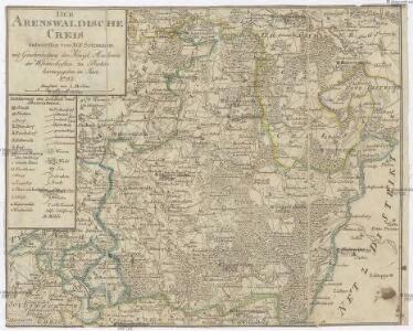
Der Arenswaldische Creis
1 : 290000 Sotzmann, Daniel Friedrich

63. Arnswalde, uit: Topographische Uebersichtskarte des Deutschen Reiches / herausgegeben v. d. Kartogr. Abt. d. Königl. Preuß. Landesaufnahme
1 : 200000 titelvariant: Topogr. Übersichtskarte des Deutschen Reiches; Annotatie: Titel boven bladen ook: Topogr. Übersichtskarte des Deutschen Reiches; Annotatie geografische gegevens: Op elk blad twee maatstokken: 10 Kilometer = 5,5 cm; 1 geogr. Meile = 3,6 cm; Legenda onder op elk blad Königlich Preußische Landesaufnahme. Kartographische Abtheilung [S.l : Königlich Preußische Landesaufnahme, Kartographische Abtheilung]
Composite: 190. Callies. (Germany)
1 : 100000 Reichsamt fur Landesaufnahme
Composite: 189. Norenberg. (Germany)
1 : 100000 Reichsamt fur Landesaufnahme
Composite: 221. Schloppe. (Germany)
1 : 100000 Reichsamt fur Landesaufnahme
221. Schloppe. (Germany)
1 : 100000 Reichsamt fur Landesaufnahme
220. Arnswalde. (Germany)
1 : 100000 Reichsamt fur Landesaufnahme
190. Callies. (Germany)
1 : 100000 Reichsamt fur Landesaufnahme
Composite: 191. Deutsch-Krone. (Germany)
1 : 100000 Reichsamt fur Landesaufnahme
189. Norenberg. (Germany)
1 : 100000 Reichsamt fur Landesaufnahme
222. Schneidermuhl.
1 : 100000 Reichsamt fur Landesaufnahme
191. Deutsch-Krone. (Germany)
1 : 100000 Reichsamt fur Landesaufnahme
Composite: 222. Schneidermuhl.
1 : 100000 Reichsamt fur Landesaufnahme
Composite: 220. Arnswalde. (Germany)
1 : 100000 Reichsamt fur Landesaufnahme
188. Stargard a. d. Ihna. (Germany)
1 : 100000 Reichsamt fur Landesaufnahme
219. Pyritz. (Germany)
1 : 100000 Reichsamt fur Landesaufnahme
Composite: 219. Pyritz. (Germany)
1 : 100000 Reichsamt fur Landesaufnahme
Meßtischblatt 2965 : Radolin, 1940
1 : 250000 Radolin. - Aufn. 1935, hrsg. 1938. - 1:25000. - [Berlin]: Reichsamt für Landesaufnahme, 1940. - 1 Kt.
Meßtischblatt 1497 : Schönlanke, 1878
1 : 250000 Schönlanke. - Aufn. 1876. - 1:25000. - [Berlin]: Reichsamt für Landesaufnahme, 1878. - 1 Kt.
Meßtischblatt 1495 : Schloppe, 1878
1 : 250000 Schloppe. - Aufn. 1876. - 1:25000. - [Berlin]: Reichsamt für Landesaufnahme, 1878. - 1 Kt.
Meßtischblatt 1494 : Regenthin, 1937
1 : 250000 Regenthin. - Aufn. 1933/34. - 1:25000. - [Berlin]: Reichsamt für Landesaufnahme, 1937. - 1 Kt.
Meßtischblatt 2963 : Kl. Drensen, 1940
1 : 250000 Kl. Drensen. - Aufn. 1934. - 1:25000. - [Berlin]: Reichsamt für Landesaufnahme, 1940. - 1 Kt.
Meßtischblatt 1493 : Bernsee, 1936
1 : 250000 Bernsee. - Hrsg. 1892, bericht. 1934. - 1:25000. - [Berlin]: Reichsamt für Landesaufnahme, 1936. - 1 Kt.
Meßtischblatt 2959 : Schwachenwalde, 1934
1 : 250000 Schwachenwalde. - Hrsg. 1891, bericht. 1934. - 1:25000. - [Berlin]: Reichsamt für Landesaufnahme, 1934. - 1 Kt.
Meßtischblatt 1491 : Granow, 1892
1 : 250000 Granow. - Aufn. 1890. - 1:25000. - [Berlin]: Reichsamt für Landesaufnahme, 1892. - 1 Kt.
Meßtischblatt 1490 : Bernstein, 1891
1 : 250000 Bernstein. - Aufn. 1890. - 1:25000. - [Berlin]: Reichsamt für Landesaufnahme, 1891. - 1 Kt.
Meßtischblatt 2865 : Gr. Wittenberg, 1940
1 : 250000 Gr. Wittenberg. - Aufn. 1935, vorläuf. Ausg. 1940. - 1:25000. - [Berlin]: Reichsamt für Landesaufnahme, 1940. - 1 Kt.
Meßtischblatt 2864 : Arnsfelde, 1944
1 : 250000 Arnsfelde. - Aufn. 1935. - 1:25000. - [Berlin]: Reichsamt für Landesaufnahme, 1944. - 1 Kt.