Maps of Canadian Shield

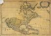
America septentrionalis
1 : 18800000 Severní Amerika Delisle, Guillaume Lotter, Georg F. apud Tobiam Conr. Lotter
America septentrionalis
1 : 18800000 Severní Amerika Delisle, Guillaume Lotter, Georg F. apud Tobiam Conr. Lotter
America septentrionalis
1 : 18800000 Severní Amerika Delisle, Guillaume Lotter, Georg F. apud Tobiam Conr. Lotter
America septentrionalis
1 : 20000000 Severní Amerika Delisle, Guillaume Lotter, Georg F. T. C. Lotter
A map of North America with the European settlements & whatever else is remarkable in ye West Indies from the latest and best observations / R.W. Seale delin. et sculp.
from Whole R.W. Seale,
L'Amerique septentrionale
1 : 16000000 dressée sur les observations de Mrs. de l'Academie Royale des Sciences & quelques autres, & sur les memoires les plus recens [...] par G. de l'Isle A Amsterdam : chez J. Cóvens & C. Mortier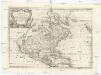
L'America settentrionale
Severní Amerika Sanson, Guillaume De Rossi, Giovanni Giacomo Gio. Giacomo de Rossi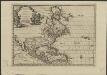
L'Amérique septentrionale, suivant les nouvelles observations de Messr. de l'Académie Royale des Sciences, etc : augmentées de nouveau
1 : 37000000 A Leide : chez Pierre vander Aa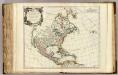
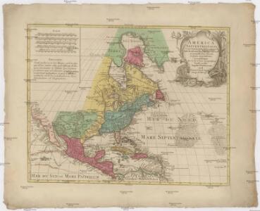
Amerique Septentrionale.
1 : 17400000 Robert de Vaugondy, Gilles, 1688-1766
An accurate map of the British, French & Spanish settlements in Nth. America and the West Indies: as stipulated by the preliminary articles of peace sign'd at Fontainebleau by the ministers of Great Britain, France & Spain, Novr. 3d, 1762. / J. Gibson sculp.
from Whole Payne, John; Gibson, John,
L'Amérique septentrionale: dressée sur les observations de Mrs. de l'Academie Royale des Sciences & quelques autres, & sur les memoires les plus recens / par G. de l'Isle, geographe.
from Whole Guillaume de l'Isle,
L'Amerique septentrionale: dressée sur les observations de Mrs. de l'Academie Royale des Sciences & quelques autres, & sur les memoires les plus recens / par G. de L'Isle, geographe.
from Whole Guillaume de l'Isle,
Nord America
1 : 16000000 entworfen und gezeichnet von C. F. Weiland gest. v. C. Jungmann Weimar : im Verlage des Geograph. Instituts
America septentrionalis
Severní Amerika Janssonius, Johannes excudit Ioannes Ianßonius
Ethnographische Karte von Nordamerika
Zweiter Band, enthaltend in vier Abtheilungen die Vertheilung der Organismen: 5. Pflanzen-Geographie, 6. Thier-Geographie, 7. Anthropographie, 8. Ethnographie Humboldt, Alexander von Verlag von Justus Perthes
A map of North America: with the European settlements & whatever else is remarkable in ye West Indies, from the latest and best observations / R.W. Seale, delin. et sculp.
from Whole R.W. Seale,
L'Amerique septentrionale: dressée sur les observations de Mrs. de l'Academie Royale des Sciences & quelques autres, & sur les memoires les plus recens / par G. De L'Isle, geographe; N. Guerard, im. et fec.
from Whole Guillaume de l'Isle; N. Guerard,
Homannův atlas světa
1 : 6600000
A new map of North America shewing its principal divisions, chief cities, townes, rivers, mountains &c.
from Whole Printed by T.W. for R. Bonwicke, J. Walthoe, R. Wilkin, and T. Ward?: [London]; Burghers, M.; Wells, Edward,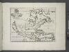
A new map of North America shewing its principal divisions, chief cities, townes, rivers, mountains & c. / delin. M. Burg.; sculpt. Univ. Oxon.; A new sett of maps both of antient and present geography: wherein not only the latitude and longitude of many places are corrected according to the latest observations, but also the most remarkable differences of antient and present geography may be quickly discern'd by a bare inspection or comparing of correspondent maps, which seems to be the most natural and easy method to lead young students (for whose use the work is principally intended) unto a competent knowledge of the geographical science: together with a geographical treatise particularly adapted to the use and design of these maps / by Edward Wells, M.A. and student of Christ-Church, Oxon.
from A new sett of maps both of antient and present geography : wherein not only the latitude and longitude of many places are corrected according to the latest observations, but also the most remarkable differences of antient and present geography may be quickly discern'd by a bare inspection or comparing of correspondent maps, which seems to be the most natural and easy method to lead young students (for whose use the work is principally intended) unto a competent knowledge of the geographical science : together with a geographical treatise particularly adapted to the use and design of these maps / by Edward Wells, M.A. and student of Christ-Church, Oxon. Wells, Edward; Sheldonian Theatre,
L'Amerique selon l'etendue de ses principales parties, 1
1 Blatt : mehrfarbig ; 49 x 61 cm Martin Will
A New map of North America with the West India Islands : divided according to the preliminary articles of peace, signed at Versailles, 20, Jan. 1783, wherein are particularly distinguished the United States, and the several provinces, governments &ca
from Whole
An accurate map of North America from the latest improvements, and regulated by astronomical observations.
from Whole s.n.: [London?]; Rollos, G.,
L'Amerique septentrionale: dressée sur les observations de Mrs. de l'Academie Royale des Sciences & quelques autres, & sur les memoires les plus recens / par G. de l'Isle, geographe.
from John H. Levine Collection Guillaume de l'Isle,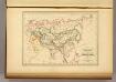
Empire des Mongols.
1 : 35000000 Malte-Brun, Conrad, 1775-1826
Amérique septentrionale dressée sur les relations les plus modernes des voyageurs et navigateurs ou se remarquent les Etats unis.
from John H. Levine Collection Publiée ... par le S. Robert de Vaugondy, géographe: [Paris?]; Robert de Vaugondy, Gilles,
Chart Shewing (sic) the Communication between Europe, North America, and the Pacific.
1 : 14500000 Black, Adam & Charles
Soubor němých map pro střední školy

Nord-Amerika
Atlas der Pflanzengeographie über alle Theile der Erde Rudolphi, Ludwig Verlag der Nicolaischen Buchhandlung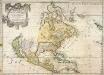
Amerique septentrionale
1 Karte : Kupferdruck ; 39 x 55 cm Sanson; Mariette; Sanson chez Pierre Mariette rue St. Iacques a l'esperance