Maps of Ukraine

Friedensdislokation im europäischen Russland
1 : 2800000 Evropa východní
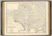
Russie occidentale, Pologne.
1 : 4060000 Picquet, C.
Übersicht des österrechisch-russischen Kriegsschauplatzes

Karta teatra Sěvernoj vojny. Perīod 1707 - 1709 gg.
Russland Nordischer Krieg <1700-1721>
Poland.
from New & accurate description of the earth in all its empires, kingdoms and states
Raab's Karte der Eisenbahnen Russland's
1 : 4750000 Evropa východní Raab, G. F. Carl Flemming
Russia Occidentale, Pologne Ancien.
1 : 4200000 Levasseur, E.
G. Freytags Karte der westrussischen Kriegsschauplätze
1 : 2000000 Evropa východní Freytag, Gustav G. Freytag & Berndt
[Sarmatia Europae et Tauricam Chersonesum]
1 : 3900000 1 Karte : Holzschnitt ; 29 x 47 cm Ptolemaeus, Claudius [Gaspard Trechsel]
Polen und Litthauen 1125-1386.
1 : 5000000 Spruner von Merz, Karl
Russie occidentale, Pologne.
1 : 4060000 Brue, Adrien Hubert, 1786-1832
Die Slaven nördlich von der Donau um 900
1 : 21000000 Osteuropa Slawen
Geologičeskaja karta Evropejskoj Rossii
1 : 2500000 Westblatt Karpinskij, A.P. (Aleksandr Petrovič) Kartografičeskoe zavedenie A.Il'ina
Karte von Polen und den ehemals dazu gehörigen Provinzen
1 : 8200000 Bělorusko Sotzmann, Daniel Friedrich von D.F. Sotzmann
[Osteuropa]
Evropa východní
Polen nach der dritten Theilung 1795
1 : 20000000 Polen Teilung Polens <1795>
Polen und Litthauen nach der Lubliner Union 1569 und dem Aussterben der Jagiellonen 1572
1 : 12000000 Polen-Litauen
Poland.
from Carey's general atlas, improved and enlarged : being a collection of maps of the world and quarters, their principal empires, kingdoms, &c.
Polen vom Anfange des XVIII Jahrhunderts bis zum Untergange der Republik 1795
1 : 5000000 Polen-Litauen, Teilungen Polens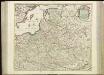
[71][71] Regni Poloniae et Ducatus Lithuaniae ..., uit: Atlas sive Descriptio terrarum orbis
Annotatie: Gedigitaliseerde versie. Amsterdam. Heiloo : Picturae (vervaardiger), 2015. tiff-bestand. Gedigitaliseerd: 07-01-2015; Origineel: Universiteitsbibliotheek Vrije Universiteit (XL.05127.-) ; Netherlands; Titelpagina ontbreekt Wit, Frederik de Amsterdam : Frederick de Wit
Polska za Władysława Łokietka roku 1333
Evropa jihovýchodní
Lechia za Bolesława Wstydliwego roku 1279
Evropa jihovýchodní
Polska czyli Lechia od Bolesława Krzywoustego między synów podzielona roku 1139
Evropa jihovýchodní
Osteuropa 1815
Osteuropa Kunz, Andreas ; Treiling, Thomas ; Moeschl, Joachim Robert
Polen vor dem Frieden v. Andrussow 1667
1 : 20000000 Polen-Litauen Russisch-polnischer Krieg <1654-1667>

Polen nach der zweiten Theilung 1793
1 : 20000000 Polen Teilung Polens <1793>
Polen nach der ersten Theilung 1772
1 : 20000000 Polen Teilung Polens <1772>
Polen bis zu seinem Untergange 1795.
1 : 5000000 Spruner von Merz, Karl