Maps of Transylvanian Alps

Tabula Bannatus Temesiensis
1 : 407000 Banát Griselini, Francesco Cipps, Augustin Johann Paul Krauss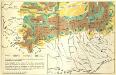
[Siebenbürgen : Weidewirtschaft]
Siebenbürgen Transhumanz
Orsova
1 : 750000 Oršava (Rumunsko) Kotrtsch, F. K. u. k. Militärgeographisches Institut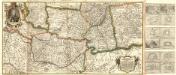
Neu Eröffnetes Kriegs Theatrum das ist Gantz Neue und Accurate Special Landkarten
Mollova mapová sbírka
Die Walachei (14.-18. Jahrhundert)
Walachei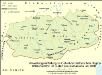
Verwaltungseinteilung im Gebiet der historischen Region Walachei bzw. im Süden Großrumäniens um 1930
Walachei Rumänien (Süd), Verwaltungsgliederung Zwick, J.
Die Walachei im 18./19. Jahrhundert
Walachei Städtenetz, Siedlung Zwick, J.
Hvngaria cvm adiacentibvs Provinciis nova et accuratiori forma exhibetur
1 : 1500000 Mollova mapová sbírka Weigel, Christoph Weigel, Christoph I.
Transylvania Sibenburgen. [Karte], in: Theatrum orbis terrarum, sive, Atlas novus, Bd. 1, S. 108.
1 Karte aus Atlas Blaeu, Joan Blaeu, Willem Janszoon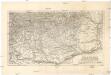
Die Walachei
1 : 800000 Valašsko (Rumunsko) Kiepert, Heinrich Hanemann, August Geographisches Institut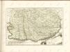

Overzichtskaart van het Rumeensche oorlogstooneel
1 : 1500000 Annotatie geografische gegevens: De kaart toont spoorwegen in exploitatie en in aanleg [S.l. : Top. Inr.]
Transylvania, Siebenburgen. [Karte], in: Novus atlas absolutissimus, Bd. 2, S. 296.
1 Karte aus Atlas Janssonius Offizin
Transylvania Sibenburgen. [Karte], in: Le théâtre du monde, ou, Nouvel atlas contenant les chartes et descriptions de tous les païs de la terre, Bd. 1, S. 230.
1 Karte aus Atlas Blaeu, Willem Janszoon und Blaeu, Joan Blaeu, Willem Janszoon
Strassen- und Eisenbahnkarte des oesterreichischen Kaiserthumes
1 : 864000 Blatt 12 Schaller, G. K.K. Militärisch-Geografisches Institut, Karten-Evidenthaltungs-Abteilung
H.7. Orsova, uit: [Übersichtskarte von Europa 1:750.000]
1 : 750000 Wien : K.u.K. Militärgeographisches Institut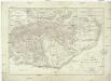
Generalcharte der Walachey
1 : 740000 Rumunsko Fried, Franz Kunst und Industrie Comptoir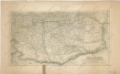
Die Walachei

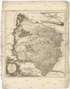
Ungarn. Comit. Krassó, Zaránd. Walachei. Illyrien. Siebenbürgen. Comit: Hunyad, Kükülö, Unter- und Ober Weißenburger. Stühle: Dreystuhler, Repser, Schäßburg, Groß Schenker, Medjascher, Leschkirchner, Hermannstädter, Reißmärker, Mühlenbacher & Brooder Stuhl. Districte: Fogaras & Kronstadt
Ungarn Verkehrsweg
Carte der Wallachei
1 : 1000000 Valašsko (Rumunsko) Adam, Jakob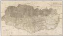
Topographische Karte der Grossen und Kleinen Wallachey
1 : 580000 Rumunsko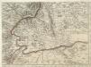
Augustissimo Romanor. Imperatori Iosepho I. Hungaria Regi Invictissimo Mappam Hanc Regni Hungariae
1 : 540000 Mollova mapová sbírka Müller, Johann Christoph
Übersichtskarte von Mittel - Europa
Carte der Besitznehmung der Wallachey von den K.K. Truppen unter Com.do des F.M. P. v. Sachsen Cobur
1 Karte : Kupferdruck ; 12 x 17 cm [Trattner]
Nagyszeben (Hermannstadt), Brassó (Kronstadt), Bukarest, Craiova, Vidin, Rusčuk
1 : 750000 Brašov (Rumunsko : oblast) Korb, L. K. u. k. Militärgeographisches Institut
Hermannstadt, Kronstadt, Bukarest, Craiova, Vidin, Rusčuk
1 : 750000 Brašov (Rumunsko : oblast) K. k. militär-geographisches Institut
XV, uit: General-Karte des oesterreichischen Kaiserstaates mit einem grossen Theile der angrenzenden Länder / durch Josef Scheda ... bearb. und hrsg
1 : 576000 Annotatie geografische gegevens: Maatstokken: oesterreichische Meilen, geografische oder deutsche Meilen, preussische Meilen, türkische Berri, französische Lieues, russische Werste; Maatstok per blad: wiener Klafter, öster. Meilen; Blad XIX: statistische en taalkundige informatie; Blad XIX: legenda [Wien : K.K. Militärisch-Geografisches Institut]
Sheet XV: Karte Des Oesterreichischen Kaiserstaates.
1 : 576000 Scheda, Josef