Maps of Pardubice

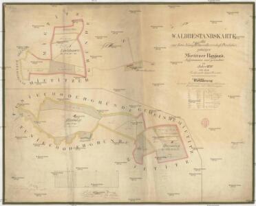
Waldbestandskarte des zur kais. könig. Kameralherrschaft Pardubitz gehörigen Mietitzer Reviers
1 : 3000 Pardubice-oblast (Česko) Jiřička, Josef
Pardubitz - c5633-1-006 - Kaiserpflichtexemplar der Landkarten des stabilen Katasters
1 : 2880
Pardubitz - c5633-1-007 - Kaiserpflichtexemplar der Landkarten des stabilen Katasters
1 : 2880
Pardubitz - c5633-1-003 - Kaiserpflichtexemplar der Landkarten des stabilen Katasters
1 : 2880
Pardubitz - c5633-1-009 - Kaiserpflichtexemplar der Landkarten des stabilen Katasters
1 : 2880
Pardubitz - c5633-1-011 - Kaiserpflichtexemplar der Landkarten des stabilen Katasters
1 : 2880
Pardubitz - c5633-1-005 - Kaiserpflichtexemplar der Landkarten des stabilen Katasters
1 : 2880
Pardubitz - c5633-1-002 - Kaiserpflichtexemplar der Landkarten des stabilen Katasters
1 : 2880
Pardubitz - c5633-1-004 - Kaiserpflichtexemplar der Landkarten des stabilen Katasters
1 : 2880
Pardubitz - c5633-1-001 - Kaiserpflichtexemplar der Landkarten des stabilen Katasters
1 : 2880
Pardubitz - c5633-1-010 - Kaiserpflichtexemplar der Landkarten des stabilen Katasters
1 : 2880
Pardubitz - c5633-1-008 - Kaiserpflichtexemplar der Landkarten des stabilen Katasters
1 : 2880
Pardubitz (Pardubice)

Indikační skica mapy stabilního katastru pro obec Doubravice I.-III.
1 : 2880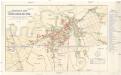
Orientační plán královského komorního města Pardubic
1 : 7400 Pardubice (Česko) Mužík, Jan Jan Liebich
Indikační skica mapy stabilního katastru pro obec Mnětice I.-VI.
1 : 2880
Hospodářská mapa Bělobranské dubiny
1 : 2880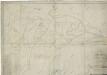
Mapa lesů města Pardubice nacházejících se mezi Spojilem, Kolodějemi, Sezemicemi a Počáply, tzv. Bělobranská dubina (koncept)
1 : 2529
Indikační skica mapy stabilního katastru pro obec Dražkovice I.-IV.
1 : 2880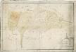
Mapa obecních lesů revíru Koloděje
1 : 2591
Rositz (Rosice) - c6538-1-001 - Kaiserpflichtexemplar der Landkarten des stabilen Katasters
1 : 2880
Rositz (Rosice) - c6538-1-002 - Kaiserpflichtexemplar der Landkarten des stabilen Katasters
1 : 2880
Rositz (Rosice) - c6538-1-004 - Kaiserpflichtexemplar der Landkarten des stabilen Katasters
1 : 2880
Rositz (Rosice) - c6538-1-003 - Kaiserpflichtexemplar der Landkarten des stabilen Katasters
1 : 2880
Mětitz - c4769-1-002 - Kaiserpflichtexemplar der Landkarten des stabilen Katasters
1 : 2880
Mětitz - c4769-1-003 - Kaiserpflichtexemplar der Landkarten des stabilen Katasters
1 : 2880
Mětitz - c4769-1-001 - Kaiserpflichtexemplar der Landkarten des stabilen Katasters
1 : 2880
Nemoschitz - c5030-1-002 - Kaiserpflichtexemplar der Landkarten des stabilen Katasters
1 : 2880
Nemoschitz - c5030-1-004 - Kaiserpflichtexemplar der Landkarten des stabilen Katasters
1 : 2880
Nemoschitz - c5030-1-003 - Kaiserpflichtexemplar der Landkarten des stabilen Katasters
1 : 2880