Maps of Tyrol

Strassen Karte von Tyrol und Vorarlberg
1 : 432000 Tyrolsko (Rakousko)

[Le Tirol]

Principali Dignitate Gaudens Comit[atus] Tirolis Episcopat[us] Tridentinum Et Brixiensem
Seutter, Matthäus Lotter
Reichsratwahlkarte

TYROLIS | COMITATVS.
[Amsterdam : Joan Blaeu]
Handkarte der Gefürsten Grafshaft Tirol mit dem Lande Vorarlberg
Tyrolis comitatvs
1 : 625000 Annotatie: Origineel is Blad 121 in atlas factice; Annotatie geografische gegevens: Schaalstok linksonder: Milliaria Germanica Joan Blaeu 1597/98-1673 [Amstelaedami] : [Ioannis Blaeu]
Schutzhütten- u. Uebersichts-Karte der Ostalpen, westliches Blatt, neue Ausgabe 1900
1 : 500000 Deutscher und Österreichischer Alpenverein Verlag Ludwig Ravenstein
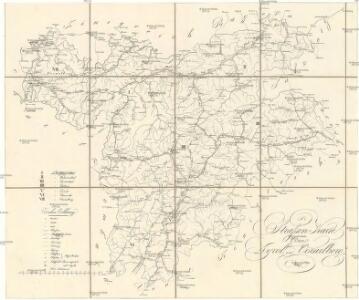
Strassen-Karte von Tyrol und Vorarlberg
1 : 432000 Tyrolsko (Rakousko)
Strassen-Karte von Tyrol und Vorarlberg
1 : 432000 Tyrolsko (Rakousko)
Strassen Karte von Tyrol und Vorarlberg
1 : 432000 Tyrolsko (Rakousko)
Strassen-Karte von Tyrol und Vorarlberg
1 : 432000 Tyrolsko (Rakousko)
Strassen-Karte von Tyrol und Vorarlberg
1 : 432000 Tyrolsko (Rakousko)
Wandkarte von Tirol und Vorarlberg : für Volks- und Mittelschulen
Kaler, G. v. Wagner
Karte von der gefürsteten Grafschaft Tyrol
1 Karte : Kupferdruck ; 47 x 56 cm Walch zufinden in Kunst u. Landkarten Verlag des I. Walch
Karte von der gefürsteten Grafschaft Tyrol
1 Karte : Kupferdruck ; 46 x 55 cm Walch zufinden in Kunst u. Landkarten Verlag des I. Walch

Karte von der gefürsteten Grafschaft Tyrol
1 : 560000 Itálie severní Walch, Johann in Kunst u. Landkarten Verlag des I. Walch
Comitatus Principalis Tirolis in quo Episc. Tridentinus et Brixensis, Comitatus Brigantinus, Feldkirchiae, Sonnebergae et Pludentii
Homann, Johann Baptist Homann
Comitatus Principalis Tirolis in quo Episc. Tridentinus et Brixensis, Comitatus Brigantinus, Feldkirchiae, Sonnebergae et Pludentii
Homann, Johann Baptist Homann
Comitatus Tyrolis tabula
1 : 1040000 Tyrolsko (Rakousko) Granelli, Carlo Engelbrecht, Christian Pfeffel et Engelbrecht
Land und Wasser-Strassen-Karte von Tyrol
1 : 438000 Tyrolsko (Rakousko) Waniek, Wenzel W.
Kronland Tyrol und Vorarlberg und souveraines Fürstenthum Liechtenstein
Flemming
Postkarte von Tirol und Vorarlberg
1 : 1000000 Zoller, Franz Karl
Le Tyrol sous le nom duqúel l'on comprend Le Comté De Tyrol, les Comtés annèxes de Bregentz, Feldkirck, Monfort, Pludentz, &c. et les Evéchés de Trente, Et De Brixen, sous la protection des Comtes de Tyrol
Robert de Vaugondy, Gilles
Le Tyrol sous le nom duqúel l'on comprend Le Comté De Tyrol, les Comtés annèxes de Bregentz, Feldkirck, Monfort, Pludentz, &c. et les Evéchés de Trente, Et De Brixen, sous la protection des Comtes de Tyrol
Robert de Vaugondy, Gilles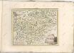

Post- und Reise-Karte von Tirol und Vorarlberg
Unterberger