Maps of Egypt

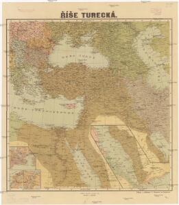
Říše turecká
1 : 5000000 Asie jihozápadní V. Neubert
[Recto], uit: Midden-Oosten (Nabije-Oosten) / [aardrijksk. medew. G.J. de Vries]
1 : 13700000 Annotatie: Verso: namen van de landen van het Midden-oosten met aanduiding van de oppervlakte en het aantal inwoners,de hoofdsteden met vermelding van het het aantal inwoners, en informatie over het Suezkanaal; Annotatie geografische gegevens: Inzet: Suez Kanaal Gerben Johannes de Vries 1886-1968 Sneek : Tonnema
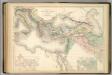
Regna succesorum Alexandri Magni
1 : 9400000 Asie jihozápadní Spruner, Karl von Alt, Wilhelm Justus Perthes
Tableau l'historie de l'Empire des Califes et de l'Empire de Turquie.
1 : 20000000 Duval, Henri
[Das Mittelländische Meer und Nord-Afrika, Östliches Blatt]
Hand-Atlas über alle Theile der Erde und über das Weltgebäude Stieler, Adolf Justus Perthes
Osmanisches Reich und seine Schutzstaaten im XVIIten Jahrhundert
1 : 9000000 Osmanisches Reich Protektorat
Anciens Empires Jusqua Alexandre.
Andriveau-Goujon, J.
Turquia asiàtica / Ramon Alabern lo grabó
1 mapa. Datat al 1850 aproximadament. Alaber, Ramon
[Das Mittelländische Meer und Nord-Afrika]
Handatlas über alle Theile der Erde und über das Weltgebäude Stieler, Adolf Justus Perthes
Imperii Romani.
1 : 9850000 Vivien de St Martin, L.
A map of the eastern part of the Roman empire
1 Karte : Kupferdruck ; 39 x 42 cm s.n.
Das persisch-macedonische Reich
Makedonie F. Tempský
Evropa, 4
1 Blatt : 50 x 57 cm Homännische Erben
Mittelbach's Karte des Türkischen Reiches mit Südrussland, Kaukasus, Persien, Ägypten, Arabien
1 : 5000000 Arabský poloostrov Mittelbachs Verlag
Imperia Persarum et Macedonum.
1 : 12000000 Kiepert, Heinrich, 1818-1899
[Afrika, Blatt 2]
Adolf Stieler's Handatlas über alle Theile der Erde und über das Weltgebäude Stieler, Adolf Justus Perthes
Turcia Asiatica : exhibens Natoliam modernam, in suos beglirbegatus divisam, itemque reliquos beglirbegatus, sive gubernationes et Prœfecturas generales, in regionibus Georgiæ, Armeniæ, Mespotamiæ, Syriæ et Arabiæ sitos, una cum Mari Nigro, Mari Azowiensi, Mari di Marmora, et Mari Ægeo, atque adiacentibus Insulis : C. P. S. C. M. = Carte de la Turquie asiatique contenant la Natolie moderne divisée en les beglerbeys &
1 : 4800000 Homann Erben (Firm) Homannianorum Heredum
Das osmannische Reich, XVIIten Jahrhundert.
1 : 9200000 Spruner von Merz, Karl
Osmanisches Reichs.
1 : 11800000 Radefeld, Carl Christian Franz, 1788-1874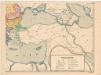
Evropa XIX. století: od vídeňského kongresu r. 1815, do rozhodnutí na frontách světové války r. 1918
Kašpar, Jan
Das türkische Reich
Afrika severní
Der orientalische Kriegsschauplatz aus der Vogelschau

Asia occidental I
1 mapa. Datat al s.XIX. 0 Gras y compañia, editores. Madrid
Tableau historique de l'Empire d'Oriens.
1 : 18500000 Duval, Henri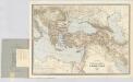
Carte générale des provinces européennes et asiatiques de l'Empire Ottoman, uit: Carte générale des provinces européennes et asiatiques de l'Empire Ottoman (sans l'Arabie) / dressée par Henri Kiepert ; le trait et la lettre gravés chez L. Kraatz ; le figure du terrain gravé par J. Sulzer
1 : 3000000 Annotatie: Op omslag ook: Deuxième édition entièrement corrigée et augmentée d'un index alphabétique (quatrième édition de la 'Carte générale de l'Empire Ottoman en Europe et en Asie'); Met: Index alfabétique. - 40 p; Annotatie geografische gegevens: Legenda Johann Samuel Heinrich Kiepert 1818-1899; Leopold Kraatz; J. Sulzer Berlin : Dietrich Reimer (Hoefer u. Vohsen) / ([S.l. : L. Kraatz])
Orbis Romani Pars Orientalis.
1 : 10137600 Lucas, Fielding Jr.
Orbis Romani, pars orientalis.
1 : 4300000 Anville, Jean Baptiste Bourguignon d, 1697-1782
Türkey
Allgemeiner Atlas [Walch, Johannes] im Verlag bei Johannes Walch
Imperium Turcicum
Turecko