Maps of Vojvodina

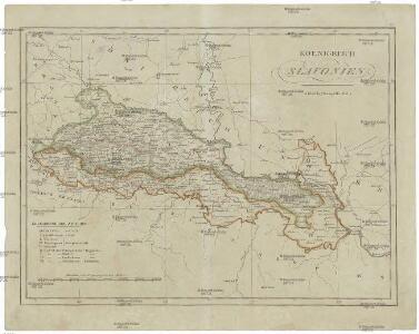
Königreich Slavonien
1 : 770000 Slavonie (Chorvatsko) Tranquillo Mollo
Koenigreich Slavonien
1 : 828000 Slavonie (Chorvatsko) Mollo, Tranquillo Tranquillo Mollo
Tabvla geographica exhibens regnvm Sclavoniae cum Syrmii ducatu
Slavonie (Chorvatsko) ab Homannianis Heredibus
Tabvla geographica exhibens regnvm Sclavoniae cum Syrmii ducatu
Slavonie (Chorvatsko) ab Homannianis Heredibus
Tabvla geographica exhibens regnvm Sclavoniae cum Syrmii ducatu
Slavonie (Chorvatsko) Hommanianis Heredibus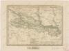
Slavonsko
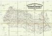
Strassen-Karte der slavonischen Militair Grenze
1 : 440000 Bosna a Hercegovina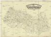
Strassen-Karte der Slavonischen militair Grenze
1 : 440000 Bosna a Hercegovina
Tabvla Geographica exhibens Regnvm Sclavoniae cum Syrmii Ducatu Ex mappa grandiori desumta et in lucem
1 : 610000 Mollova mapová sbírka Homann, Johann Baptist Homann, Johann Baptista - dědici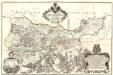
Tabula Geographica Nova et Exacta Distincte exhibens Regnum Sclavoniae cum Syrmii Ducatu
1 : 300000 Mollova mapová sbírka Gadea, Joseph

Slawonien-Syrmien 1745-1918
Slawonien, Sirmien, Verwaltungsgliederung Zwick, J.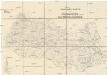
Strassen-Karte der Slavonischen Militair Grenze
1 : 432000 Slavonie (Chorvatsko)
Ungarn:. Comitate: Baranya, Bács, Csanád, Temes, Torontal. Slavonien. Comit.: Sirmien, Veröcze. Militär Gränze: Brod, Petervardein, Csajkisten Kreisz, Deutschbanater Regiment
Ungarn Verkehrsweg
Strassen- und Eisenbahnkarte des oesterreichischen Kaiserthumes
1 : 864000 Blatt 11 Schaller, G. K.K. Militärisch-Geografisches Institut, Karten-Evidenthaltungs-Abteilung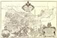
Tabula Geographica Nova et Exacta Distincte exhibens Regnum Sclavoniae cum Syrmii Ducatu
1 : 300000 Mollova mapová sbírka Gadea, Joseph Schmuzer, Johann Adam Schmuzer, Johann Andreas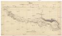
Skelett zur Übersicht der Savestrecke von Agram bis Semlin
1 : 580000 Záhřeb-oblast (Chorvatsko)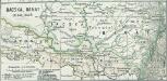
Bacska, Banat 1848, 1849
1 : 2775000 Banat, Batschka, Ungarn / Revolution <1848-1849>
Sclavonia Croatia Bosnia cum Dalmatiae Parte
1 : 930000 Mollova mapová sbírka Mercator, Gerhard Mercator, Gerard
Letecká mapa Evropy
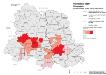
Vojvodina 1900. Nationalitäten
Wojwodina ethnische Gruppe Hofinger, Veronika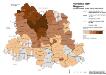
Vojvodina 1900. Magyaren
Wojwodina ethnische Gruppe, Magyaren Hofinger, Veronika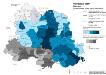
Vojvodina 1900. Serben
Wojwodina ethnische Gruppe, Serben Hofinger, Veronika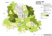
Vojvodina 1900. Deutsche
Wojwodina ethnische Gruppe, Deutsche Hofinger, Veronika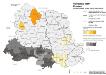
Vojvodina 1900. Kroaten
Wojwodina ethnische Gruppe, Kroaten Hofinger, Veronika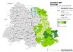
Vojvodina 1900. Rumänen
Wojwodina ethnische Gruppe, Rumänen Hofinger, Veronika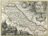
Regnum Slavoniae
1 : 1100000 Mollova mapová sbírka Bruggen, Johann van der Brugge, Johannes van der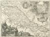
Regnum Slavoniae
1 : 1100000 Mollova mapová sbírka Bruggen, Johann van der Brugge, Johannes van der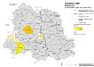
Vojvodina 1900. Ruthenen
Wojwodina ethnische Gruppe, Russinen Hofinger, Veronika