Maps of Bratislava
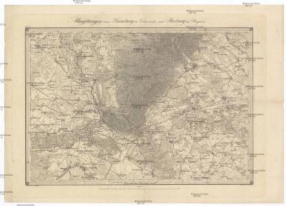
Umgebungen von Hainburg in Oesterreich, und Presburg in Ungarn
1 : 144000 Bratislava-oblast (Slovensko) Müller, A. Withalm, Andreas
Umgebung von Pozsony
1 : 75000 Bratislava (Slovensko : oblast) K. u. k. Militärgeographisches Institut
Umgebung von Poszony

III. vojenské mapování 4758
1 : 75000
Bratislava
1 : 75000 Bratislava-oblast (Slovensko) Vojenský zeměpisný ústav
Bratislava
1 : 75000 Bratislava (Slovensko : oblast) Vojenský zeměpisný ústav
Bratislava
1 : 75000 Bratislava (Slovensko : oblast) Vojenský zeměpisný ústav
Pressburg und Hainburg

Pressburg und Hainburg
1 : 75000 Bratislava, Hainburg an der Donau Geripp: Assist. Jersche. Terrain: R. Bloschitz
Pressburg und Hainburg.; Spezialkarte der osterreichisch-ungarischen Monarchie.
from Spezialkarte der osterreichisch-ungarischen Monarchie. Austro-Hungarian Monarchy. Militärgeographisches Institut.,
Presburg mit seinen Umgebungen
Bratislava-oblast (Slovensko) Zutz, Joseph
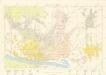
Archiducatus Austriae inferioris Geographica, et Nouiter Emendata Accuratissima Descriptio :
1 : 153333 Mollova mapová sbírka Vischer, Georg Matthaeus Hoffmann, Jakob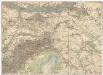
Umgebungs - Karte von Bruck an der Leitha
1 : 75000 Bruck an der Leitha (Rakousko) K. u. K. Militärgeographisches Institut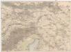
Umgebungs-Karte von Bruck an der Leitha
1 : 75000 Bruck an der Leitha (Rakousko) R. Lechner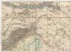
Umgebungs - Karte von Bruck an der Leitha
1 : 75000 Bruck an der Leitha (Rakousko)
III. vojenské mapování 4858
1 : 75000
Ung. Altenburg
1 : 75000 Mosonmagyaróvár, Umland Geripp: Leutn. Kimlein. Terrain: Leutn. Sachs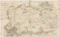
Plan des Cavallerie Manövrir-Rayons bei Parndorf im Jahre 1857
1 : 40000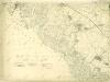
III. vojenské mapování 4758/4, 4858/2
1 : 25000
III. vojenské mapování 4758/2
1 : 25000
Plan okregu podatku konsumcyjnego w Bratislawie

III. vojenské mapování 4658/3
1 : 25000
Plan zum Treffen bei Blumenau und Pressburg 22. Juli 1866
1 : 30000 Bratislava (Slovensko) Ditfurth, Moritz von des K. u. k. Militärgeographischen Instituts
Plan der Umgebung von Bruck an der Leytha
1 : 29000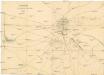
Distanzplan für die Umgebung des Lagers bei Bruck a[n]/L[eitha]
1 : 12500 Bruck an der Leitha (Rakousko)
III. vojenské mapování 4758/1
1 : 25000
Orientačné mapy: Bratislava
Bělohlav, Josef
Bratislava und Umgebung
Bratislava