Maps of Romania

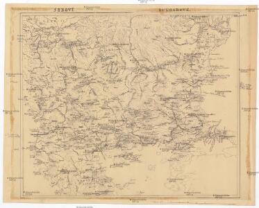
Srbové, Bulharové
Evropa jihovýchodní
Walachia Servia, Bulgaria, Romania [Karte], in: Novus atlas absolutissimus, Bd. 2, S. 305.
1 Karte aus Atlas Janssonius Offizin
Walachia Serbia, Bulgaria, Romania. [Karte], in: Theatrum orbis terrarum, sive, Atlas novus, Bd. 1, S. 111.
1 Karte aus Atlas Blaeu, Joan Blaeu, Willem Janszoon
Walachia Servia, Bulgaria, Romania. [Karte], in: Novus Atlas, das ist, Weltbeschreibung, Bd. 1, S. 207.
1 Karte aus Atlas Blaeu, Joan Blaeu, Willem Janszoon
Walachia, Servia, Bulgaria, Romania
Osmanisches Reich / Europäischer Teil, Serbien Mercator, Gerhard, der Jüngere ; Blaeu, Willem Janszoon
Walachia Servia, Bulgaria, Romania [Karte], in: Gerardi Mercatoris et I. Hondii Newer Atlas, oder, Grosses Weltbuch, Bd. 1, S. 355.
1 Karte aus Atlas Mercator, Gerhard und Hondius, Jodocus Jansson, Jan
WALACHIA | SERVIA, BVLGA- | RIA, ROMANIA
Per Gerardum Mercatorem Guiljelmus Blaeu excudebat
Walachia Servia, Bulgaria, Romania [Karte], in: Gerardi Mercatoris Atlas, sive, Cosmographicae meditationes de fabrica mundi et fabricati figura, S. 481.
1 Karte aus Atlas Mercator, Gerhard Montanus, Petrus

Walachia Servia, Bulgarie, Romania. [Karte], in: Le théâtre du monde, ou, Nouvel atlas contenant les chartes et descriptions de tous les païs de la terre, Bd. 1, S. 236.
1 Karte aus Atlas Blaeu, Willem Janszoon und Blaeu, Joan Blaeu, Willem Janszoon

România Mare şi romanii Macedonia şi Ucraina
Rumänien Moldawien Ukraine
Carte ethnographique de la Turquie d'Europe
Dunaj (Rumunsko a Ukrajina : řeka : delta) Lejean, G. Petermann, August Justus Perthes
Danubii fluminis (hic ab urbe Belgrado, per Mare Nigrum usq Constantinopolim defluentis exhibiti) pars infima, in qua Transylvania, Walachia, Moldavia, Bulgaria, Servia, Romania et Bessarabia cum vicinis regionibus ostenduntur
Balkanhalbinsel, Donau, Flusslauf Homann, Johann Baptist
Turkey
1 : 12330000 Turecko Walker, C. Baldwin & Cradock
Map of the Balkan States
Balkanhalbinsel
Colton's Turkey in Europe.
1 : 1600000 Colton, G.W.
Turkey in Europe.
1 : 4000000 Colton, G.W.
Turkey in Europe.
1 : 3000000 Colton, G.W.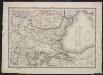
Voenno-dorožnaja karta časti Rossii i pograničnych zemelʹ
1 : 1680000 Balkanhalbinsel, Osmanisches Reich Šubert [Generalmajor]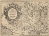
Romaniae, (quae olim Thracia dicta) Vicinarumque Regionum, Uti Bulgariae, Walachiae, Syrfiae, Etc. Descriptio. [Karte], in: Theatrum orbis terrarum, S. 378.
1 Karte aus Atlas Ortelius, Abraham Vrients, Jan Baptista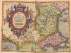
Romaniae, (quae olim Thracia dicta) Vicinarumque Regionum, Uti Bulgariae, Walachiae, Syrfiae, Etc. Descriptio. [Karte], in: Theatrum orbis terrarum, S. 283.
1 Karte aus Atlas Ortelius, Abraham
Turkey in Europe.
1 : 4000000 Colton, G.W.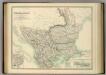
Turkey in Europe.
1 : 2533000 Johnston, Alexander Keith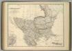
Turkey in Europe.
1 : 2533000 Johnston, Alexander Keith
Epoca Asanilor şi primele alcatuiri româneşti
Rumänien
Northern Turkey in Europe, with part of Hungary and Dalmatia
1 : 3000000 Arrowsmith, Aaron Jr.
Schul-Atlas für die alte Erdbeschreibung : zur allgemeinen Schul-encyclopädie gehörig
J. H. Campe Zusammensetzung und Zeichnung von [...] Dufour, unter Leitung von Heusinger ; gestochen von Frentzel. Braunschweig : Schulbuchhandlung
Europae tabula IX
1 : 5600000 1 Karte : Kupferdruck ; 19 x 25 cm Ptolemaeus, Claudius [Vincenzo Valgrisi]