Maps of West Indies

Mappa geographica regionem Mexicanam et Floridam
1 : 11560000 Antily (souostroví) Lotter, Tobias Conrad [sumptibus] Tobiae Conradi Lotteri
Mappa geographica regionem Mexicanam et Floridam
1 : 11560000 Antily (souostroví) Seutter, Matthäus Lotter, Tobias Conrad sumptibus Mathaei Seutteri
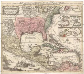
Mappa geographica regionem Mexicanam et Floridam terrasque adjacentes, ut et anteriores Americae insulas, cursus itidem et reditus navigantium versus flumen Missisipi et alias colonias ob oculos ponens
1 : 9300000 cura et sumptibus Tobiae Conradi Lotteri, Geographi Et Chalcographi Tob. Con. Lotter sculps. Augustae Vindel : [Tobias Conrad Lotter]
REGNI MEXICANI seu NOVAE HISPANIAE, LUDOVICIANAE, N. ANGLIAE, CAROLINAE, VIRGINIAE et PENSYLVANIAE nec non INSVLARVM ARCHIPELAGI MEXICANI IN AMERICA SEPTENTRIONALI accurata Tabula
1 : 9900000 Jižní Karolína Homann, Johann Baptist a Ioh. Baptista Homanno
REGNI MEXICANI seu NOVAE HISPANIAE, LUDOVICIANAE, N. ANGLIAE, CAROLINAE, VIRGINIAE et PENSYLVANIAE
1 : 11110000 Antily (souostroví) Bellin, Jacques-Nicolas â Ioh. Baptista Homanno
Carte du Mexique et de la Floride des Terres Angloises et des Isles Antilles du cours et des environs de la riviere de Mississipi
1 : 9000000 dressée sur un grand nombre de memoires principalement sur ceux de Mrs. d'Iberville et le Sueur par Guillaume De l'Isle geographe de l'Academie Royale des Sciences I. Stemmers Senior sculp. A Amsterdam : chez Jean Covens & Corneille Mortier

Regni Mexicani seu Novæ Hispaniæ, Ludovicianæ, N. Angliæ, Carolinæ, Virginiæ, et Pensylvaniæ, nec non insvlarvm archipelagi Mexicani in America septentrionali accurata tabula
1 Karte : Kupferdruck ; 46 x 55 cm Homann Johann Baptist Homann
Regni Mexicani seu Novae Hispaniae, Ludovicianae, N. Angliae, Carolinae, Virginiae, Pensylvaniae, necnon insvlarvm archipelagi Mexicani in America Septentrionali / accurata tabula exhibita a Ioh. Baptista Homanno.
from Parts John Baptista Homann, S.,
Regni Mexicani seu Novae Hispaniae, Ludovicianae, N. Angliae, Carolinae, Virginiae, Pensylvaniae, necnon insularum archipelagi Mexicani in America Septentrionali / accurata tabula exhibita à Ioh. Baptista Homanno.
from Charts and maps John Baptista Homann, S.,
Carte du Mexique et de la Floride, des terres angloises et des Isles Antilles, du cours et des environs de la riviere de Mississipi / dressée sur un grand nombre de memoires principalement sur ceux de Mrs. d'Iberville et le sueur, par Guillaume De l'Isle, geographe de l'Academie Royale des Sciences; I. Stemmers senior sculp.
from Mexico Guillaume de l'Isle; I. Stemmers,
Mexique, Floride, Terres Angloises, Isles Antilles.
1 : 9000000 L'Isle, Guillaume de, 1675-1726
Mexique, Floride, Terres Angloises, Isles Antilles.
1 : 9000000 L'Isle, Guillaume de, 1675-1726
Insulae Americanae in Oceano Septentrionale.
From Whole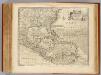
West Indies.
1 : 12500000 Bowen, Emanuel
Mexico, Guatemala, W.I., North America.
Goodrich, S.G.

Our Country Present And Prospective.
1 : 3168000 Gaston, Samuel N.
Republics Of North America
1 : 3041280 Johnson, D. Griffing
Carte générale de l'Amérique séptentrionale: avec les posséssions Angloises dans cette partie du nouveau monde / dressée sur la carte de Pople [sic], publiée à Londres en 20 feuilles, pour servir à l'intelligence de la guerre présente.
from Whole Henry Popple,
New National Map Exhibiting The United States
1 : 3800000 Mitchell, Samuel Augustus
Colton's Railroad and Military Map, United States.
1 : 6500000 Colton, G.W & C.B.
Our Country, Present & Prospective.
1 : 3801600 Gaston, Samuel N.
Facsimile: British Empire in America by Popple.
1 : 18000000 Popple, Henry
Republics Of North America
1 : 3041280 Colton, J. H.
A new map of North America with the West India Islands: divided according to the preliminary articles of peace, signed at Versailles, 20, Jan. 1783; wherein are particularly distinguished the United States and the several provinces, governments & ca. which compose the British dominions / laid down according to the latest surveys and corrected from the original materials of Goverr. Pownall, Membr. of Parliamt., 1783.
from Charts and maps Governor Pownall,
A map of the British Empire in America: with the French, Spanish and Hollandish settlements adjacent thereto / by Henry Popple; I. Condet s.
from John H. Levine Collection Henry Popple; I. Condet s.,
Amerique septentrionale: suivant la carte de Pople faite à Londres en 20 feuilles.
from Charts and maps Par et chez le Sr. le Rouge ...: Paris; Lawson, Oscar A.; Le Rouge, Georges-Louis,
America Septentrionalis A Map of the British Empire in America.
1 : 11000000 Popple, Henry