Maps of Israel

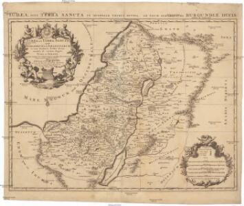
Iudaea seu Terra Sancta quae Hebraeorum sive Israelitarum in suas duodecim tribus divisa, secretis ab invicem regnis Iuda et Israel expressis insuper sex ultimi temporis ejusdem terrae provinciis
1 : 615000 Izrael Sanson, Guillaume Mortier, Pieter apud Petrum Mortier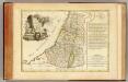
Douze Tribus d'Israel.
1 : 1030000 Bonne, Rigobert, 1727-1794
Afbeelding van 't Joodsche land toen het aan de heerschappy der Romeinen onderworpen, met derzelver vergunning bestiert wierd, door koning Herodes den Groten, en deszelfs nageslagt : strekkende tot opheldering der geschiedenis van Christus
1 : 900000 door W.A. Bachiene J. van Jagen mapp. sculpsit, et figur. apposit. sculpturam curavit ; S. Fokke fecit. te Gorinchem : by Nicol: Goetzee
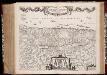
[78][78] Terra Sancta, sive promissionis, olim Palestina, uit: Atlas sive Descriptio terrarum orbis
Annotatie: Gedigitaliseerde versie. Amsterdam. Heiloo : Picturae (vervaardiger), 2015. tiff-bestand. Gedigitaliseerd: 07-01-2015; Origineel: Universiteitsbibliotheek Vrije Universiteit (XL.05127.-) ; Netherlands; Titelpagina ontbreekt Wit, Frederik de Amsterdam : Frederick de Wit
Typus Chorographicus, Celebrium Locorum In Regno Iudae Et Israhel. [Karte], in: Theatrum orbis terrarum, S. 438.
1 Karte aus Atlas Ortelius, Abraham Vrients, Jan Baptista
Typus Chorographicus, Celebrium Locorum In Regno Iudae Et Israhel. [Karte], in: Theatrum orbis terrarum, S. 436.
1 Karte aus Atlas Ortelius, Abraham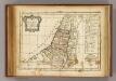
12 tribus d'Israel.
1 : 2000000 Delamarche, Charles Francois
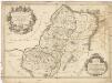
Royaume d'Herode.
1 : 2300000 Houze, Antoine Philippe
Palaestina.
1 : 1400000 Anville, Jean Baptiste Bourguignon d, 1697-1782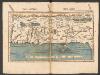
Tabula Moderna Terre Sancte [Karte], in: Claudii Ptolemei viri Alexandrini mathematice discipline philosophi doctissimi geographie opus [...], S. 272.
1 Karte aus Atlas Waldseemüller, Martin [und Ptolemaeus, Claudius] Übelin, Georg

Iudaea seu terra sancta
1 : 600000 Izrael Sanson, Guillaume Cordier, Louis apud Hubertum Iaillot
Palestina nynější

Tabula Moderna Terre Sancte [Karte], in: [Clavdii Ptholomei Cosmographi ...], S. 311.
1 Karte aus Atlas Nicolaus Germanus [und Ptolemaeus, Claudius]
La Terre Sainte partagee en 12 tribus.
1 : 2800000 Houze, Antoine Philippe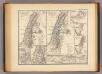
Syria Phoenice, Syria Palaestina, Provinciae ab aerae Christianae anno 70 usque ad Diocletiani tempus; Phoenice, Coelesyria, Decapolis, Iudaea Herediadarum tempore.
1 : 2000000 Menke, Th.
Palestina za doby soudců a králů

Kaart van 't land Kanaan / naar de beste waarnemingen tot verstand van Num. XXI:14-31 ontworpen door R. Schutte ; J. van Jagen sculps. 1766
1 : 800000 Annotatie: Waarschijnlijk blad uit zakatlas Schutte, Rutger; Jagen, J. van Te Amsterdam : by J. Loveringh
Palästina
Volksschul-Atlas über alle Teile der Erde Lange, Henry Druck und Verlag von Georg Westermann

Iudaea, seu Terra Sancta quae hebraeorum sive Israelitarum in suas duodecim tribus divisa, secretis ab invicem regnis Iuda, et Israel expressis insuper sex ultimi temporis ejusdem terrae provinciis
1 : 600000 Izrael Sanson, Guillaume Schenk, Pieter Pierre Schenk
Iudaea, seu Terra Sancta quae Hebraeorum sive Israelitarum in suas duodecim tribus divisa, secretis ab invicem regnis Iuda, et Israel expressis insuper sex ultimi temporis ejusdem terrae provinciis
1 : 600000 Izrael Sanson, Guillaume Schenk, Pieter Pierre Schenk
Palestine.
1 : 684288 Stanford, Edward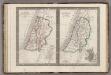
Palestine.
1 : 1650000 Monin, C.V.
Homannův atlas světa
1 : 570000
Palaestina za času Krista Pána
1 : 1030000 Izrael Fáborský, Jan B. Dědictví sv. Cyrilla a Methodia
Palaestina za času Krista Pána
1 : 1030000 Izrael Fáborský, Jan B. Dědictví sv. Cyrilla a Methodia
Palestine
1 : 1000000 Colton, G.W.