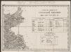
Maps of powiat nyski

Přehledná mapa panství biskupství Vratislavského v Československé republice podle stavu ke dni 1. ledna 1929
1 : 75000 Vratislav-oblast (Polsko) Bauer, E. Vojenský zeměpisný ústav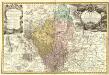
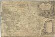
Principatvs Silesiae Grotkani exactissima Tabula geographica exhibens Terram Nissensem simul ac Circulos Grotkau Ottmuchau, et Ziegenhals.
1 : 154000 Mollova mapová sbírka Wieland, Johann Wolfgang Homann, Johann Baptista - dědici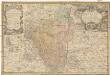
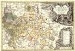
Principatvs Silesiae Grotkani exactissima tabula geographica exhibens terram Nissensem simul ac circulos Grotkau, Ottmuchau, et Ziegenhals
1 : 154000 Gródkow (Polsko) Wieland, Johann Wolfgang Schubarth, Matthäus ab Haeredibus Homannianis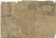
Principatvs Silesiae Grotkani exactissima tabula geographica exhibens terram Nissensem simul ac circulos Grotkau Ottmuchau, et Ziegenhals
1 : 154000 Gródkow (Polsko) Wieland, Johann Wolfgang Schubarth, Matthäus Homannianos Heredes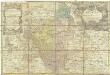
Principatvs Silesiae Grotkani exactissima tabula geographica exhibens terram Nissensem simul ac circulos Grotkau Ottmuchau, et Ziegenhals
1 : 154000 Gródkow (Polsko) Wieland, Johann Wolfgang Schubarth, Matthäus Haeredibus Homannianis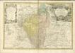
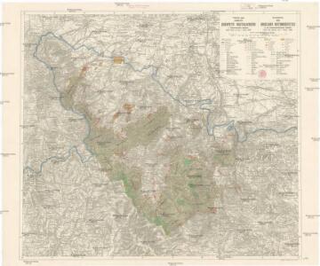
Komunikační mapa země Moravskoslezské
1 : 100000 Jeseník (Česko : oblast) Morslez. zem. výbor
DVCATVS SILESIÆ | GROTGANVS | cum Districtu Episcopali | NISSENSI
Amstelædami J. Blaeu excudit
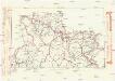
146. Ratibor, uit: Topographische Uebersichtskarte des Deutschen Reiches / herausgegeben v. d. Kartogr. Abt. d. Königl. Preuß. Landesaufnahme
1 : 200000 titelvariant: Topogr. Übersichtskarte des Deutschen Reiches; Annotatie: Titel boven bladen ook: Topogr. Übersichtskarte des Deutschen Reiches; Annotatie geografische gegevens: Op elk blad twee maatstokken: 10 Kilometer = 5,5 cm; 1 geogr. Meile = 3,6 cm; Legenda onder op elk blad Königlich Preußische Landesaufnahme. Kartographische Abtheilung [S.l : Königlich Preußische Landesaufnahme, Kartographische Abtheilung]
Umgebungen von Friedberg und Freywaldau
Jeseník-oblast (Česko)
Umgebungen von Friedberg und Freywaldau
1 : 144000 K.K. Militärisches Geographisches Institut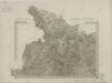
II. vojenské mapování 1
1 : 144000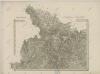
II. vojenské mapování 1
1 : 144000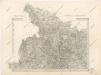
Special - Karte der Markgrafschaft Maehren und des Herzogthums Schlesien

II. vojenské mapování - speciální mapa Markrabství moravského s částí Slezského vévodství 1
1 : 144000
Hotzenplotz und Zuckmantel.
from Spezialkarte der osterreichisch-ungarischen Monarchie.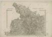
II. vojenské mapování 1
1 : 144000
Jeseníky


Jauernig und Weidenau.
from Spezialkarte der osterreichisch-ungarischen Monarchie.
Reymann ́s Special Karte 190 Troppau
Umgebungen von Jägerndorf und die statistische Uebersicht
1 : 144000 K.K. Militärisches Geographisches Institut
Dvcatvs Silesiae Grotganvs cum Districtu Episcopali Nissensi
1 : 315000 Mollova mapová sbírka Scultetus, Johannes Schenk, Peter I
Dvcatvs Silesiae Grotganvs cum Districtu Episcopali Nissensi
1 : 315000 Mollova mapová sbírka Scultetus, Johannes Blaeu, Joan I.
171 Neisse, uit: Topographische Special-Karte von Deutschland (von Central-Europa) / begründet von D.G. Reymann ; [entworfen und gezeichn. von Heinrich Berghaus... [et al.]]
1 : 200000 Annotatie: Lit.: Daniel Gottlob Reymann und die "Topographische Special-Karte von Deutschland" / von Wolfgang Scharfe, in: Kartographische Nachrichten, 39 (1989), Heft I, p. 1-10; Handgeschreven titel: Reymann's Deutschland : 24 Sectionen: Jena, Penig, Dresden, Zittau, Hirschberg, Breslau, Brieg, Andernach, Coblenz, Giessen, Fulda, Schleusingen, Plauen, Zwickau, Teplitz, Jung Bunzlau, Hohenelbe, Glatz, Neisse, Simmern, Prag, Luxemburg, Birkenfeld; Aanwezig: 23 bladen Reymann, Daniel Gottlob; Berghaus, Heinrich [Berlin : 2. Departement des Kriegsministeriums, Bureau für Plan- und Kartenzeichnung]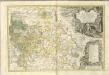
Principatvs Silesiae Karnoviensis nova et exactissima Tabula geographica, commonstrans insimul districtus ac Statvs Minores Frevdenthal Olbersdorf et Stevberndorf.
1 : 1125000 Mollova mapová sbírka Wieland, Johann Wolfgang Homann, Johann Baptista - dědici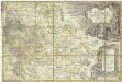
Principatvs Silesiae Karnoviensis nova et exactissima tabula geographica commonstrans insimul districtus ac statvs minores Frevdenthal, Olbersdorf et Stevberndorf
1 : 100000 Bruntál-oblast (Česko) Wieland, Johann Wolfgang Schubarth, Matthäus Homannianos Heredes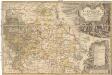
Principatvs Silesiae Karnoviensis nova et exactissima tabula geographica commonstrans insimul districtus ac statvs minores Frevdenthal Olbersdorf et Stevberndorf
1 : 100000 Bruntál-oblast (Česko) Wieland, Johann Wolfgang Schubarth, Matthäus ab Haeredibus Homannianis