Maps of Southern Transdanubia

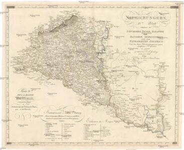
Niederungern
Chorvatsko východní Ossenbrug, J. von Timlich, K. im Verlage des Kunst- u. Industrie-Comptoirs
Niederungern
Chorvatsko východní Ossenbrug, J. von Timlich, K. im Verlage des Kunst- u. Industrie-Comptoirs
Nieder Ungern
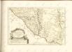

Sclavonia Croatia Bosnia cum Dalmatiae Parte
1 : 930000 Mollova mapová sbírka Mercator, Gerhard Mercator, Gerard
Slavonsko

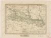
Königreich Slavonien
1 : 770000 Slavonie (Chorvatsko) Tranquillo Mollo
Koenigreich Slavonien
1 : 828000 Slavonie (Chorvatsko) Mollo, Tranquillo Tranquillo Mollo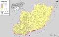
Serben in Süd-Transdanubien und im Komitat Bács-Kiskun 1880
Transdanubien (Süd), Bács-Kiskun, Serben, Siedlung Bottlik, Zsolt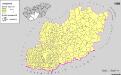
A szerbek aránya és száma a Dél-Dunántúlon és Bács-Kiskun megyében 1980-ban
Transdanubien (Süd), Bács-Kiskun, Serben, Siedlung Bottlik, Zsolt
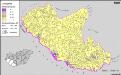
Serben in Süd-Transdanubien und im Komitat Bács-Kiskun 1941
Transdanubien (Süd), Bács-Kiskun, Serben, Siedlung Bottlik, Zsolt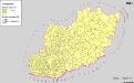
A szerbek aránya és száma a Dél-Dunántúlon és Bács-Kiskun megyében 1941-ben
Transdanubien (Süd), Bács-Kiskun, Serben, Siedlung Bottlik, Zsolt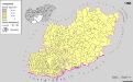
A szerbek aránya és száma a Dél-Dunántúlon és Bács-Kiskun megyében 1880-ban
Transdanubien (Süd), Bács-Kiskun, Serben, Siedlung Bottlik, Zsolt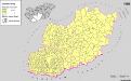
Serben in Süd-Transdanubien und im Komitat Bács-Kiskun 1980
Transdanubien (Süd), Bács-Kiskun, Serben, Siedlung Bottlik, Zsolt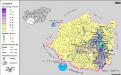
A németek településterülete a szomszédsági mutató alapján Dél-Dunántúlon 1880-ban
Ungarn (Süd) Deutsche, Siedlung Bottlik, Zsolt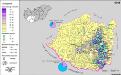
A németek településterülete a szomszédsági mutató alapján Dél-Dunántúlon 1941-ban
Ungarn (Süd) Deutsche, Siedlung Bottlik, Zsolt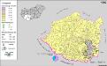
A németek településterülete a szomszédsági mutató alapján Dél-Dunántúlon 1980-ban
Ungarn (Süd) Deutsche, Siedlung Bottlik, Zsolt
Hungaria
Mollova mapová sbírka Hoffmann, Johannes Hoffmann, Johann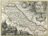
Regnum Slavoniae
1 : 1100000 Mollova mapová sbírka Bruggen, Johann van der Brugge, Johannes van der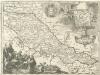
Regnum Slavoniae
1 : 1100000 Mollova mapová sbírka Bruggen, Johann van der Brugge, Johannes van der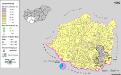
Siedlungsgebiet der Deutschen nach dem Nachbarschaftsindex für Süd-Transdanubien 1980
Ungarn (Süd) Deutsche, Siedlung Bottlik, Zsolt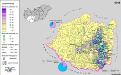
Siedlungsgebiet der Deutschen nach dem Nachbarschaftsindex für Süd-Transdanubien 1941
Ungarn (Süd) Deutsche, Siedlung Bottlik, Zsolt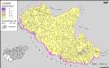
A horvátok aránya és száma Délnyugat-Magyarországon 1941-ben
Transdanubien (Süd) Kroaten, Siedlung Bottlik, Zsolt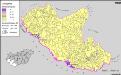
A horvátok aránya és száma Délnyugat-Magyarországon 1980-ben
Transdanubien (Süd) Kroaten, Siedlung Bottlik, Zsolt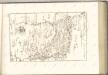
A horvátok aránya és száma Délnyugat-Magyarországon 1880-ben
Transdanubien (Süd) Kroaten, Siedlung Bottlik, Zsolt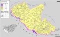
Kroaten in Südwest-Ungarn 1980
Transdanubien (Süd) Kroaten, Siedlung Bottlik, Zsolt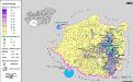
Siedlungsgebiet der Deutschen nach dem Nachbarschaftsindex für Süd-Transdanubien 1880
Ungarn (Süd) Deutsche, Siedlung Bottlik, Zsolt