Maps of Central America

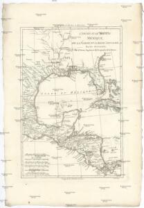
L'Ancien et le Nouveau Méxique, avec la Floride et la Basse Louisiane
1 : 10500000 Florida Bonne, Rigobert André
Monk's new map of Central America, Cuba, Florida &c.
1 : 2600000 Monk, Jacob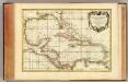
Golfe du Mexique.
1 : 10000000 Rizzi Zannoni, Giovanni Antonio Bartolomeo, 1736-1814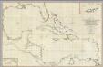
A General Chart of the West Indies And Gulf Of Mexico.
1 : 2100000 Dessiou, J. Foss
Mapa Gegraphica
Střední Amerika Anville, Jean-Baptiste Bourguinon d' Homanianis Heredibus
Centralamerica, West Indien.
1 : 10000000 Radefeld, Carl Christian Franz, 1788-1874
Mexico, or, New Spain : in which the motions of Cortes may be traced
1 : 10200000 Kitchin, Thomas, d. 1784 W. Strahan and T. Cadell
Kriegsschauplatzkarte von Cuba : Mittel-Amerika, Spanien und die Vereinigten-Staaten ; Cuba
1 : 8000000 Annotatie geografische gegevens: Toont bezittingen van Europese zeemachten; Inzet: [Transatlantische afstandenkaart] Berlin : Reimer
Mexico South, Central America.
1 : 6462720 Letts, Son & Co.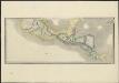
Mexico and Guatemala, shewing the position of the mines
1 : 4500000 London : Jas. Wyld
A map of East and West Florida, Georgia, and Louisiana, with the islands of Cuba, Bahama, and the countries surrounding the Gulf of Mexico, with the tract of the Spanish galleons, and of our fleets thro' the Straits of Florida, from the best authorities
1 : 5300000 Lodge, John Bew, John
YVCATAN | Conventus Iuridici Hispaniæ | Novæ Pars Occidentalis, et | GVATIMALA | CONVENTVS IVRIDICVS
[Amsterdam : Joan Blaeu]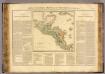
Guatimala.
1 : 5600000 Buchon, J. A. C.; Carey, H. C.; Lea, I.
Central America, S. Mexico.
1 : 7100000 Society for the Diffusion of Useful Knowledge (Great Britain)
Amerique Centrale.
1 : 4300000 Vivien St Martin, L.
Die Vulkanreihe von Quatemala

Plan von Mexico
1 : 740000 Mexiko
Die Vulkanreihe von Guatemala, die Landengen von Tehuantepec, Nicaragua und Panama; und die Central-Vulkane der Süd See
Erster Band, enthaltend in vier Abtheilungen die Erscheinungen der anorganischen Natur: 1. Meteorologie und Klimatographie. 2. Hydrologie und Hydrographie. 3. Geologie. 4. Tellurischer Magnetismus Humboldt, Alexander von Verlag von Justus Perthes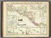
Die Vulkanreihe von Guatemala, (etc.).
Berghaus, Heinrich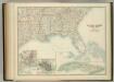
United States of North America (South East Sheet).
1 : 3984000 Johnston, W. & A.K.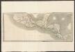
Mexico and Guatemala
A new general atlas of modern geography, consisting of a complete collection of maps of the four quarters of the globe Wyld, James James Wyld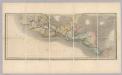
Mexico and Guatemala.
1 : 4200000 Wyld, James, 1812-1887
Etats Unis Flle. S.E.
1 : 5000000 Vivien St Martin, L.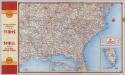
Shell Highway Map Southeastern Section of the United States.
1 : 3231360 Shell Oil Company
(Vereinigte Staaten v. Nordamerika) IV.
1 : 8000000 Berghaus, Heinrich; Flemming, Carl; Sohr, Karl
Central America. Guatemala, Honduras, Nicaragua, Costa Rica and Jamaica.
1 : 5500000 Colton, G.W.
Central America.
1 : 5248000 Johnson, A.J.
Central America.
1 : 3041280 Fullarton, A. & Co.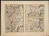
La Florida. Auctore Hieron Chiaves.
When first issued in 1584 as a copper engraving by Ortelius in his Theatrum Orbis Terrarum 1584-1612, this was one of the few sixteenth century maps based on Spanish sources; in this case drawn from reports of Hernando de Soto's expedition through the region. There are three maps on this sheet. The most important map (La Florida) is the first printed map of the southeastern portion of the United States. This influential map provided the foundation cartography for the region, particularly in the depiction of the river system. The map below (Guastecan Reg) combines with La Florida to extend the coastline of the Gulf of Mexico further south. The third is a map of Peru, where De Soto was the first Spaniard to meet Inca Emperor Atahuallpa. In the north of the map of Peru is Aurea Regio, or Kingdom of Gold, a reference to the fabled El Dorado. Text on verso. Chaves, Geronimo, 1523-1574.;Ortelius, Abraham, 1527-1598. Ortelius, Abraham, 1527-1598.