Maps of Mascarene Islands
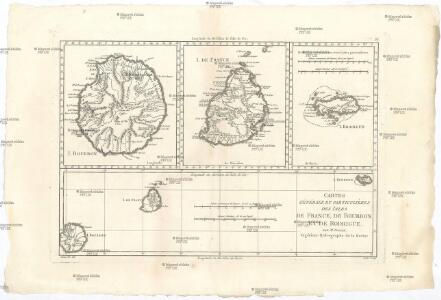
Cartes générale et particuliéres des isles de France, de Bourbon et de Rodrigue
1 : 2530000 Mauricius Bonne, Rigobert André
Afrika. Politische Ubersicht
1 : 20000000 Scobel, Albert
A correct map of the African islands of Bourbon, and Mauritius or the Isle of France
1 : 887040
Neue Charte von der Insel Bourbon od Reunion
Réunion Bory de Saint-Vincent, Jean-Baptist Genevieve Marcellin
Neue CHARTE von der Insel BOURBON od REUNION
Réunion Bory de Saint-Vincent, Jean-Baptist Genevieve Marcellin
Isle De La Reunion.
1 : 588000 Levasseur, Victor.
Map of the island of Mauritius
1 : 63360 Mauricius Descubes, A. A. Descubes
CHARTE von ÎLE DE FRANCE oder der Insel Frankreich
Mauricius Bory de Saint-Vincent, Jean-Baptist Genevieve Marcellin
Charte von Ile de France oder der Insel Frankreich
Mauricius Bory de Saint-Vincent, Jean-Baptist Genevieve Marcellin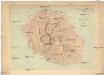
Ile de la Réunion
1 : 100000 Réunion Lépervanche, Paul Samary, Paul Augustin Challamel
Neue Charte von der Insel Bourbon od Reunion
Réunion Bory de Saint-Vincent, Jean-Baptist Genevieve Marcellin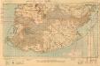
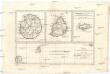
Mauritius, South
[A collection of maps of Mauritius]. [S.l.] : [s.n.]
Port Louis (1903)
Map of vicinity of Port Louis. Ink and watercolour on paper. The map was subsequently printed as Intelligence Division, War Office, No.1730. -- 'Capt Harrison i/c Survey Sect' ― War Office catalogue. Harrison, William Albert.
Charte von Zanguebar der Kafferküste und der Insel Madagascar : nach den neuesten und besten Hülfsmitteln
1 : 6800000 Reinecke, J. C. M. (Johann Christoph Matthias), 1770-1818 Im Verlag des Industrie Comptoirs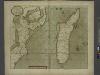
A new draught of the Island of MADAGASCAR ats St. LORENZO with Augustin Bay and the Island of Mombass at Large
from The sea-atlas : containing an hydrographical description of most of the sea-coasts of the known parts of the world.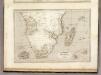
Afrique Meridionale.
1 : 14100000 Montemont, A.
Afrique Meridionale.
1 : 15000000 Garnier, F. A., 1803-1863
Uebersichts-Karte der ethnographischen Verhältnisse von Asien und von den angrenzenden Theilen Europa'sbearbeitet und herausgegeben mit Unterstützung der kaiserlichen Akademie der Wissenschaften in Wien von Vinzenz v. Haardt
Hartenthurn, Vincenz
Islands In The Indian Ocean (with) inset map of Mauritius.
1 : 23760000 Tallis, J. & F.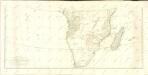

Indian Ocean Islands.
Society for the Diffusion of Useful Knowledge (Great Britain)
Costa oriental de Africa
1 : 25000000 1 mapa, col. Full d'un atles en llengua castellana no identificat, que conté mapes físics, polítics i sobre el servei de correus. Datat al 1890 aproximadament.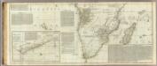
(Africa, with all its states, kingdoms, republics, regions, islands, &ca. Southern section)
1 : 8400000 Boulton, S.
Tabula Moderna Secunde Porcionis Aphrice [Karte], in: Claudii Ptolemei viri Alexandrini mathematice discipline philosophi doctissimi geographie opus [...], S. 266.
1 Karte aus Atlas Waldseemüller, Martin [und Ptolemaeus, Claudius] Übelin, Georg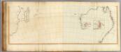
Asia (south).
1 : 11000000 Anville, Jean Baptiste Bourguignon d, 1697-1782; Kitchin, Thomas; Robert Laurie & James Whittle
[Indischer Ozean, westlicher Teil]
1 Karte : Kupferdruck ; 57 x 45 cm Doncker Hendrik Doncker
Occidentalior tractus Indiarum Orientalium à promontorio Bonæ Spei ad C. Comorin
1 Karte : Kupferdruck ; 43 x 54 cm Renard à L. Renard
[138][141] Occidentalior Tractus Indiarum Orientalium ..., uit: Atlas sive Descriptio terrarum orbis
Annotatie: Gedigitaliseerde versie. Amsterdam. Heiloo : Picturae (vervaardiger), 2015. tiff-bestand. Gedigitaliseerd: 07-01-2015; Origineel: Universiteitsbibliotheek Vrije Universiteit (XL.05127.-) ; Netherlands; Titelpagina ontbreekt Wit, Frederik de Amsterdam : Frederick de Wit
Carte marine de l'Afrique meridionale
1 Karte : Kupferdruck ; 41 x 48 cm Königliche Akademie der Wissenschaften