Maps of Appennini

Etat de l'eglise et duché de Toscane
1 : 1740000 Toskánsko (Itálie) Bonne, Rigobert André
Generalkarte von Zentraleuropa

Bassins du Tibre, de l'Arno, et du Garigliano : (Italie centrale)
1 : 2120000 Vuillemin, Alexandre Aimé 1812-1880 Paris : Delalain
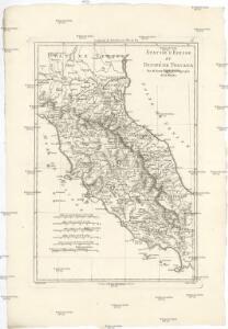
Statvs ecclesiastici nec noc magni dvcatvs Toscaniae nova tabvla geographica
1 : 2780000 Papežský stát Mayer, Tobias curantibus Homannianis Heredibus
Statvs ecclesiastici nec noc magni dvcatvs Toscaniae nova tabvla geographica
1 : 2780000 Toskánsko (Itálie) Mayer, Tobias curantibus Homannianis Heredibus
X, uit: General-Karte von Mittel-Europa in 12 Blättern, im Masse 1:1.200.000 / entworfen, bearb. und hrsg. von Josef Schlacher
1 : 1200000 Annotatie: Blad 6 ontbreekt; Annotatie geografische gegevens: 21 maatstokken op blad 9; Legenda op blad 9 Wien : K.K. Militär Geografisches Institut
Italy, North Part.
1 : 2500000 Tanner, Henry S.
Estats de L'Eglise et de Toscane. [Karte], in: Atlas nouveau, contenant toutes les parties du monde [...], Bd. 2, S. 132.
1 Karte aus Atlas Sanson, Nicolas Jaillot, Alexis Hubert und Mortier, Pieter
Zu den Ereignissen in Neapel und Spanisch-Tascana und zur Occupation des Kirchenstaates
Neapol (Itálie : oblast) K.k. Generalstabes
Kirchenstaat
1 : 1100000 Itálie střední Biller, Bernhardt bey Tranquillo Mollo
Kirchenstaat
1 : 1100000 Itálie střední Biller, Bernhardt bey Tranquillo Mollo
Italiae pars media.
1 : 1250000 Kiepert, Heinrich, 1818-1899
Oesterreichisch-Ungarische Monarchie
Etat de l'Eglise.
1 : 1500000 Clouet, J. B. L. (Jean-Baptiste Louis), b. 1730
Stato Della Chiesa, Con La Toscana. [Karte], in: Novus Atlas, das ist, Weltbeschreibung, Bd. 3, S. 157.
1 Karte aus Atlas Blaeu, Joan Blaeu, Willem Janszoon
Statvs Ecclesiastici nec non Magni Dvcatvs Toscanae nova Tabvla Geographica
1 : 930000 Mollova mapová sbírka Mayer, Tobias Homann, Johann Baptista - dědici
Stato Della Chiesa, Con La Toscana. [Karte], in: Theatrum orbis terrarum, sive, Atlas novus, Bd. 3, S. 137.
1 Karte aus Atlas Blaeu, Joan Blaeu, Willem Janszoon
Les Etats de l'Eglise et de Toscane
1 : 880000 Mollova mapová sbírka Fer, Nicolas de
Stato Della Chiesa. Dominium Ecclesiasticum In Italia. [Karte], in: Gerardi Mercatoris et I. Hondii Newer Atlas, oder, Grosses Weltbuch, Bd. 2, S. 299.
1 Karte aus Atlas Mercator, Gerhard und Hondius, Jodocus Jansson, Jan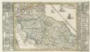
Italien Eigendlich also genandt
1 : 2900000 Mollova mapová sbírka Bodenehr, Gabriel Bodenehr, Gabriel

Stato Della Chiesa Con La Toscana [Karte], in: Novus atlas absolutissimus, Bd. 5, S. 142.
1 Karte aus Atlas Janssonius Offizin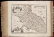
Stato della Chiesa con la Toscana
1 : 1035000 Annotatie: Met opdracht van Henricus Hondius; Origineel is Blad 162 in atlas factice; Annotatie geografische gegevens: Schaalstokken op de kaart: 60 Milliaria Italica communia (=10 cm), en: 12 Milliaria Germanica communia (=8,6 cm) Amstelodami : Sumptibus Ioannis Ianssonii
Status Ecclesiastici nec non Magni Ducatus Toscanae nova tabula geographica
1 : 930000 secundum principia legitimae delineationis descripta a Tob. Majero curantibus Homannianis Heredibus. Norimbergae : Homanniani Heredes
Italia střední
Itálie Lotter, Tobias Conrad Wagner, Jan Eduard sklad Karla Andréa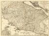
Etats de l'Eglise
1 : 850000 Mollova mapová sbírka Nolin, Jean-Baptiste Nolin, Jean Baptiste II.
Status Ecclesiastici Magnique Ducatus Florentini
1 : 870000 Mollova mapová sbírka Homann, Johann Baptist Homann, Johann Baptista
Estats de l'Eglise et de Toscane
1 : 780000 Mollova mapová sbírka Jaillot, Jean-Baptiste-Michel Renou de Chauvigné dit Jaillot, Jean-Baptiste Michel
Status Ecclesiastici nec non magni dvcatvs Toscanae nova tabvla geographica
1 : 937000 Papežský stát Mayer, Tobias curantibus Homannianis Heredibus