Maps of Metropolitan France

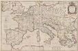
Imperium Romanum
1 : 11100000 Evropa západní Bonne, Rigobert
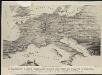
Orbis Romani, occidentalis.
1 : 11500000 Anville, Jean Baptiste Bourguignon d, 1697-1782; M'Dermut, Robert
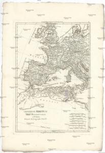
Imperii Romani, distracta
1 : 22200000 Evropa střední Bonne, Rigobert André
Orbis Romani, pars occidentalis.
1 : 4300000 Anville, Jean Baptiste Bourguignon d, 1697-1782
Orbis Romani Pars Occidentalis.
1 : 10137600 Lucas, Fielding Jr.
Orbis Romani pars occidentalis
1 : 10600000 Evropa západní Anville, Jean-Baptiste Bourguinon d' Küffner, Paul in officina Weigelia-Schneideriana
Orbis Romani pars occidentalis
1 : 10000000
Carte de la Germanie et les diferents etats ou ses peuples ont porté leurs conquestes
Evropa jižní Chatelain, Henri-Abraham Chatelain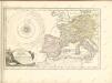

Imperii Romani.
1 : 9850000 Vivien de St Martin, L.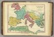
Patriarchati Occidentalis. (1826)
1 : 12100000 Tanner, Henry S.
Carte des costes maritimes de l'Europe
1 Karte : Kupferdruck ; 64 x 48 cm Nolin; Basset; Basset chez Basset rue St. Jacques
Carte des costes maritimes de l'Europe
1 Karte : Kupferdruck ; 64 x 48 cm Nolin; Daumont chez Daumont rue de la Feronnerie
[Historisch-geographischer Atlas zu den allgemeinen Geschichtswerken von C. v. Rotteck, Pölitz u. Becker] : Die Reiche im Süden Europa's im Anfange des achten Jahrhunderts
von Julius Loewenberg Lithographie von B. Herder in Freiburg im Breisg. [Freiburg im Breisgau] : [Herder]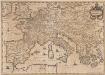
Imperium Caroli Magni [Karte], in: Novus atlas absolutissimus, Bd. 4, S. 28.
1 Karte aus Atlas Janssonius Offizin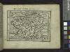
Gallia.
from Abraham Ortelius his epitome of the theater of the worlde / nowe latlye ... renewed and augmented ... by Micheal Coignet, mathematitian of Antwarpe.
Imperii Caroli Magni et vicinarum regionum Descriptio [Karte], in: Le théâtre du monde, ou, Nouvel atlas contenant les chartes et descriptions de tous les païs de la terre, Bd. 2, S. 165.
1 Karte aus Atlas Blaeu, Willem Janszoon und Blaeu, Joan Blaeu, Willem Janszoon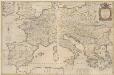
Imperii Caroli Magni et vicinarum regionum Descriptio [...] [Karte], in: Novus Atlas, das ist, Weltbeschreibung, Bd. 2, S. 165.
1 Karte aus Atlas Blaeu, Joan Blaeu, Willem Janszoon
Europe 1.
1 : 2800000 Anville, Jean Baptiste Bourguignon d, 1697-1782
L'ocean pres d'Europe
1 Karte : Kupferdruck ; 46 x 34 cm Duval chez l'auteur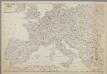
Centraal-, West-, en Zuid-Europa
1 : 3700000 [S.l. : s.n.]
Karte von Europa, 3
4 Blätter : 53 x 70 cm Verlag der Königlich-Preussischen Academie-Kunst- und Buchhandlung
Spain and Portugal.
from New & accurate description of the earth in all its empires, kingdoms and states
Western Europe - communications.
1 : 5300000 John Bartholomew and Son
[Historisch-geographischer Atlas zu den allgemeinen Geschichtswerken von C. v. Rotteck, Pölitz u. Becker] : Das Weströmische Reich bis zu seinem Untergange unter Romulus Augustulus
von Julius Loewenberg Lithographie von B. Herder in Freiburg im Breisgau [Freiburg im Breisgau] : [Herder]
Carte des routes de postes de l'Empire francais du royaume d'Italie et de la Confédération du Rhin
Evropa západní Tardieu, Pierre François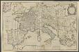
IMPERII | CAROLI MAGNI | et vicinarum regionum | DESCRIPTIO, | Dedicata et inscripta | LVDOVICO, | REGI, VICTORI, | ET DEFENSORI ECCLESIÆ | CHRISTI
ab Auctore Petro Bertio | ejusdem Cosmographo. [Amsterdam : Joan Blaeu]
Západní Evropa při konci XIV. věku
Stannard & Son's, panoramic birds-eye view of France & Prussia and the surrounding countries likely to be involved in the War, with the railways & startegic positions of each army, & the great fortresses of the Rhine provinces
1 : 1