Maps of Regensburg
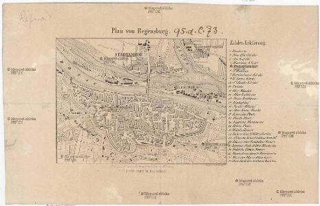
Plan von Regensburg
Řezno (Německo) Bruder, D. Fr. Pustet
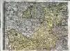
Topographische Karte der Gegend zwischen der Donau, Abens, und Iser
1 : 57000 Bavorsko (Německo) Reißer, Franz
Topographische Karte der Gegend zwischen der Donau, Abens, und Iser
1 : 57000 Bavorsko (Německo) Reißer, Franz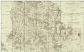
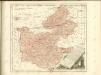
Topographische Karte der Gegend zwischen der Donau, Abens, und Iser
1 : 57000 Bavorsko (Německo) Reißer, Franz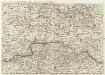
S. R. Imp. Circuli Franconici Geographica Delineatio Francken-Land mit Seinen Gräntzen
Mollova mapová sbírka Endter, Wolfgang Moritz Endter, Wolfgang Moritz
exhibet Continuationem Partis Palatinatus Super: Regiminis Straubing: et Villam Jmperialem Augusta Tiberii
1 : 150000 Mollova mapová sbírka Buna, Wilhelm C. Broenner, Heinrich Ludwig
Pars II. exhibet continuationem partis palatinatus super: regiminis Straubing: et villam jmperialem Augusta Tiberii
1 Karte : 54 x 52 cm Heinrich Ludwig Broenner
Continuations Plan deren Königl. Kriegs Unsernehmungen in Bayern
Mollova mapová sbírka Lidl, Johann Jakob Lidl, Johann Jacob
Mappa geographica regni Bohemiae in duodecim circulos divisae ...

Entwurf der Bewegungen und Schlachten welche den 19. 20. 21. 22. und 23. April 1809 zwischen den Alliirt. Französischen und Oestreichischen Armeen in den Gegenden von Tann, Abensberg, Landshuth, Ekmühl, Regensburg, die Campagne eröffneten

Regensburg 130, uit: Special-Karte von Mittel-Europa / nach amtlichen Quellen bearbeitet von W. Liebenow
1 : 300000 titelvariant: W. Liebenow's Mittel-Europa; Annotatie: Titel boven de bladen: W. Liebenow's Mittel-Europa Johannes Wilhelm Liebenow 1822-1897 Frankfurt a. M. : Ludwig Ravenstein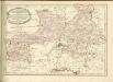
Sacri Romani imperii circuli et electoratus Bavariae tabula, 3
4 Blätter : s.n.
Mappa Electoratus et Ducatus Bavariae Superioris et Inferioris, Ducatus Neoburgesis cum Episcopatibus Frisingensi Ratisbonensi Passaviensi et Praepositura Bergtolsgadensi.
1 : 260000 Mollova mapová sbírka Apian, Philipp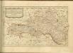

C. Flemming's Karte von Deutsch - Französischen Kriegsschaupltze

Carte topographique d'Allemagne contenant le Haut Palatinat, une partie du royaume de Boheme, de la Basse Baviere
1 Karte : Kupferdruck ; 46 x 61 cm Jaeger; Facius I. W. A. Iaeger ches qui cette carte se vend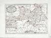
Des Herzogthums Oberpfalz südliche Pfleggerichte
1 Karte : Kupferdruck ; 24 x 35 cm Reilly F. J. J. von Reilly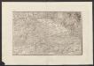
Militair Karte von Süd-Deutschland in 20 Sectionen
1 : 400000 11. Section Coulon, Alois von A. von Coulon
Palatinatvs Bavariæ
1 Karte : Kupferdruck ; 35 x 47 cm Valck; Schenk apud G. Valk et P. Schenk
Palatinatvs Bavariæ
1 Karte : Kupferdruck ; 36 x 48 cm Blaeu excudit Guiljelmus Blaeuw
Palatinatvs Bavariæ
1 Karte : Kupferdruck ; 35 x 48 cm Hondius; Mercator; Janssonius apud Ioannem Ianssonium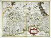
Palatinatvs Bavariae
1 Karte : Kupferdruck ; 35 x 48 cm Mercator; Hondius excusum apud Henricum Hondium sub insigno Atlantis
Palatinatvs Bavariae
1 Karte : Kupferdruck ; 35 x 48 cm Mercator s.n.
Sacri imperii Romani circuli et electoratus Bavariæ, 1
1 Karte : mehrfarbig ; R. et J. Ottens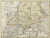
Palatinatvs Bavariae
1 : 370000 Mollova mapová sbírka Schenk, Peter
Bavariae Palatinatus vulgo Die Ober-Pfaltz in Subjacentes ejusdem Praefecturas aceuratissime divisus
1 : 300000 Mollova mapová sbírka Visscher, Nicolaes Schenk, Peter II
Palatinatus Bavariae vulgo Die Obere Pfaltz in omnes ejusdem Status et Praefecturas accuratà divisus
1 : 310000 Mollova mapová sbírka Homann, Johann Baptist Homann, Johann Baptista