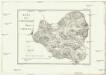
Maps of Cuenca

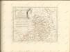
Castiliae novae pars orientalis
1 : 540000 Kastilie (Španělsko) Güssefeld, Franz L. López, Tomás apud Hommanianos Heredes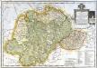
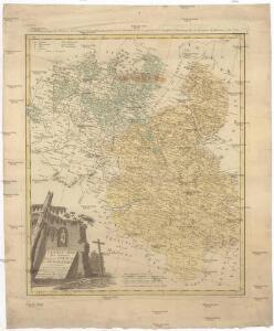
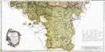
Mapa de la provincia y obispado de Cuenca
1 Karte auf 2 Blatt : Kupferdruck ; 37 x 55 cm López s.n.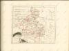
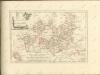

Mapa de la provincia de Guadalaxara
1 Karte : Kupferstich ; 37 x 38 cm López s.n.
Madrid
1 : 200000 1 Mapa imprès. Carpeta: Guerra Civil. Datació aproximada. C.T.V. Corpo Truppe Volontarie. Sezione Topocartografica
Madrid
1 : 200000 Coello, Francisco [Verlag nicht ermittelbar]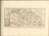

Mapa geográfico del Señorio de Molina
1 Karte : Kupferdruck ; 35 x 37 cm López s.n.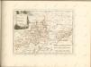
Mapa geográfico de la provincia de Soria, 2
2 Blätter : s.n.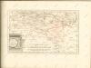

Episcopatus Tervelæ, et Albarrasin
1 Karte : Kupferdruck ; 36 x 47 cm Valck; Schenk apud G. Valk et P. Schenk
Mapa de la provincia de Madrid
1 Karte : Kupferdruck ; 33 x 37 cm López s.n.
Mapa de las cercanias de Madrid
1 Karte : Kupferdruck ; 36 x 37 cm López s.n.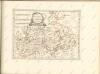

Mapa de la provincia de Madrid comprehende el partido de Madrid, y el de Almonacid de Zorita
1 : 250000 compuesto por D. Tomàs Lopez de Vargas Machuca, geografo de los Dominios de S. M [...] Madrid : [Thomas Lopez]
Episcopatus Teruelae, Et Albarrasin. [Karte], in: Novus atlas absolutissimus, Bd. 6, S. 61.
1 Karte aus Atlas Janssonius Offizin
EPISCOPATUS | TERVELENSIS | et | ALBARACINENSIS
Auct. Joanne Baptista Labanna [Amsterdam : Joan Blaeu]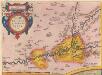
Carpetaniae Partis Descr. 1584. [Karte], in: Theatrum orbis terrarum, S. 60.
1 Karte aus Atlas Ortelius, Abraham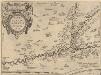
Carpetaniae Partis Descr. 1584. [Karte], in: Theatrum orbis terrarum, S. 107.
1 Karte aus Atlas Ortelius, Abraham Vrients, Jan Baptista
Madrid / formado y publicado por el Instituto Geográfico y Estadístico, bajo la direccion del excmo. señor Don Cárlos Ibañez é Ibañez de Ibero ; P. Peñas grabó
1 : 50000 Cárlos Ibañez é Ibañez de Ibero 1825-1891; P. Peñas; Instituto Geográfico y Estadístico [S.l. : Instituto Geográfico y Estadístico]
Toledo e dintorni: lavori difensivi eseguiti dal nemico [C.T.V. Corpo Truppe Volontarie. Comando Artiglieria (Itàlia)]
1 : 25000 1 Mapa imprès amb anotacions manuscrites. Carpeta: Guerra Civil. Datació aproximada. [C.T.V. Corpo Truppe Volontarie. Comando Artiglieria (Itàlia)]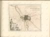

Madrid
1 : 19000 Barcelona (Španělsko) Heck, G. Lehmann
Madrid : city plan
1 : 12500 United States. Army Map Service
Ayuntamiento de Madrid. Plano de la villa
Sección de Cultura e Información -- Artes Gráficas Municipales
Nuevo plan de Madrid
1 : 20000 Bravo, Juan, lithographer