Maps of Lower Saxony

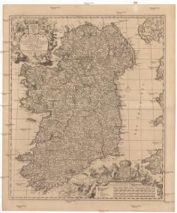
Hiberniae regnum
1 : 888000 Irsko Visscher, Nicolaus Vilém Oranžský per Nicolaum Visscher
[Das Deutsches Reich, Blatt 1]
Adolf Stieler's Handatlas über alle Theile der Erde und über das Weltgebäude Stieler, Adolf Justus Perthes
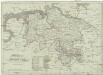
Carte Generale d'Allemagne
1 : 1300000 Mollova mapová sbírka Eisenschmidt, Johann Caspar Julien, Roch Joseph
Mappa geographica summo labore, accurate et novissime exarata, exhibens circulos aliquot Germaniae, praesertim illos ubi bellum nunc geritur
1 : 1300000 Nizozemsko Lotter, Tobias Conrad Tob. Conr. Lotter
Mappa Geographica summo labore, accurate et novissime exarata, exhibens Circulos aliquot Germaniae, praesertim illos ubi Bellum nunc Geritur
1 : 1300000 Mollova mapová sbírka Lotter, Tobias Conrad Lotter, Tobias Conrad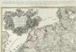
Kriegs Expeditions Karte von Devtschland
1 : 1700000 Mollova mapová sbírka Rizzi Zannoni, Giovanni Antonio Homann, Johann Baptista - dědici
Hannover, Schleswig-Holstein, norddeutsche Staaten.
1 : 1000000 Andree, Richard
Westfalia.
from Abraham Ortelius his epitome of the theater of the worlde / nowe latlye ... renewed and augmented ... by Micheal Coignet, mathematitian of Antwarpe.
Norddeutschland
Volksschul-Atlas über alle Teile der Erde Lange, Henry Druck und Verlag von Georg Westermann
Nova totius Westphaliae descriptio / emendata a F. de Wit
1 : 860000 Annotatie: Origineel is Blad 73 in atlas factice Wit, Frederik de Amsterdam : Frederick de Wit
Germany - western section.
1 : 1000000 John Bartholomew and Son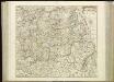
[59][59] Nova totius Westphaliae descriptio, uit: Atlas sive Descriptio terrarum orbis
Annotatie: Gedigitaliseerde versie. Amsterdam. Heiloo : Picturae (vervaardiger), 2015. tiff-bestand. Gedigitaliseerd: 07-01-2015; Origineel: Universiteitsbibliotheek Vrije Universiteit (XL.05127.-) ; Netherlands; Titelpagina ontbreekt Wit, Frederik de Amsterdam : Frederick de Wit
The seat of war in the circle of Westphalia
1 : 2543400
Operationen der alliirten und französischen Armee 1759
Koenigreich Hannover
1 : 1126000 Hannover (Německo) Tranquillo Mollo
Nova et exacta mappa geographica exhibens circulum Westphalicum in omnes suos status et provincias accurate divisum
1 : 700000 Vestfálsko (Německo) Lotter, Tobias Conrad cura et sumptibus Tobiae Conrad Lotter
Nova et exacta mappa geographica exhibens circulum Westphalicum in omnes suos status et provincias accurate divisum
1 : 700000 Vestfálsko (Německo) Lotter, Tobias Conrad Tobiae Conrad Lotter
NW pt. of Germany.
1 : 2150000 Bowen, Emanuel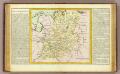
Westphalie.
1 : 1400000 Clouet, J. B. L. (Jean-Baptiste Louis), b. 1730
Summaria descriptio Fresiae Universae, cum latissime patuit nomen post emigrationem Francorum, Saxonumq. accessionem
auctore Mensone Alting Gerard de Broen fecit Amstelodami. [Amstelaedami] : [apud Henricum Wetstenium]
Holland und Berg
Allgemeiner Atlas [Walch, Johannes] im Verlag bei Johannes Walch
Charte über die saemtlichen zum Westphaelischen Kreis gehörige Laender
1 : 834000 Vestfálsko (Německo) Güssefeld, Franz L. Homaenischen Erben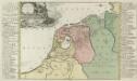
Summaria Descriptio Fresiae Vniversae; cum latissimè patuit nomen Post emigrationem Francorvm; Saxonvmq; accessionem
1 : 1400000 Mollova mapová sbírka Alting, Menso Broen, Gerrit de
Hanover, Schleswig-Holstein.
1 : 1000000 Andree, Richard; Times (London, England)
Nova totius Westphaliae Descriptio
1 : 810000 Mollova mapová sbírka Wit, Frederik de Wit, Frederick
Circulus Westphalicus, Sive Germaniae Inferioris. [Karte], in: Novus atlas absolutissimus, Bd. 2, S. 92.
1 Karte aus Atlas Janssonius Offizin
Il Circolo di Westfalia
1 : 750000 Mollova mapová sbírka Cantelli, Giacomo Donia, Francesco De Rossi, Giovanni Giacomo