Maps of Netherlands

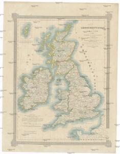
Gross-Britanien und Irland
Velká Británie Raffelsperger, Franz Kitchin, Thomas Franz Raffelsperger
Konigreich Grossbrittanien und Irland
Velká Británie Raffelsperger, Franz Kitchin, Thomas
Carte des trois royaumes d'Angleterre d'Ècosse et d'Irlande
Velká Británie Raffelsperger, Franz Kitchin, Thomas
Die britischen Inseln
Velká Británie Wyld, James Kitchin, Thomas
[Velká Británie a Irsko]
Velká Británie Lotter, Tobias Conrad Lotter, Matthäus Albrecht
Magna Britannia et Hibernia
Velká Británie Walch, Johann Kitchin, Thomas J. Walch
Grossdeutsches Reich und angrenzende Gebiete

Daniæ, Frisiæ, Groningæ et Orientalis Frisiæ littora
1 Karte : Kupferdruck ; 48 x 56 cm Renard apud L. Renard
Nouvelle carte geographique des postes des Pais Bas, de la Westphalie, & des provinces limitrophes
1 : 1
Skizze zur Orientirung ϋber den Feldzug 1814

Danemark vizt Jutland, Zeland, Sleswick, Holstein.
from A new systeme of the mathematicks: containing I. Arithmetick, as well natural and decimal, as in species, or the principles of algebra. II. Practical geometry, together with the first six books of Euclid's Elements, as also the eleventh and twelfth, symbo
Magna Britannia complectens Angliae, Scotiae et Hiberniae regn. in suas prov. et comitat.
Velká Británie Seutter, Matthäus Vilém Oranžský per Homannum
[Nordwestliches Deutschland und Kgr. Der Niederlande]
Stieler's Hand-Atlas Stieler, Adolf bei Justus Perthes
[124][127] Daniae, Frisiae, Groningae et Orientalis Frisiae littora, uit: Atlas sive Descriptio terrarum orbis
Annotatie: Gedigitaliseerde versie. Amsterdam. Heiloo : Picturae (vervaardiger), 2015. tiff-bestand. Gedigitaliseerd: 07-01-2015; Origineel: Universiteitsbibliotheek Vrije Universiteit (XL.05127.-) ; Netherlands; Titelpagina ontbreekt Wit, Frederik de Amsterdam : Frederick de Wit
Nordwestliches Deutschland, Niederlande und Belgien
Schul-Atlas über alle Theile der Erde nach dem neuesten Zustande, und über das Weltgebäude Stieler, Adolf bei Justus Perthes
Galliæ antiquæ descriptio geographica, 2
1 Blatt : 44 x 57 cm s.n.
Nordwestliches Deutschland, Niederlande und Belgien
Schul-Atlas über alle Theile der Erde nach dem neuesten Zustande, und über das Weltgebäude Stieler, Adolf Justus Perthes
Nordwestliches Deutschland, Niederlande und Belgien

Rheinprovinz, Westphalen, Holland und Belgien
Schul-Atlas in 36 Karten Völter, Daniel Verlag der J.M. Dannheimer'schen Buchhandlung
[Nordwestliches Deutschland, Kgr. der Niederlande, Kgr. Belgien]
Hand-Atlas über alle Theile der Erde nach dem neuesten Zustande und über das Weltgebäude Stieler, Adolf bei Justus Perthes
Postkarte von dem Westphaelischen und Burgundischen Kreise
Burgundsko (Francie) Kühn, Ignaz im von Reilly'schen Landkarten und Kunstwerke Verschleiss Komptoir
[Nordwestliches Deutschland, Kgr. Der Niederlande, Kgr. Belgien]
Hand-Atlas über alle Theile der Erde nach dem neuesten Zustande und über das Weltgebäude Stieler, Adolf bei Justus Perthes
L'Empire, d'Allemagne
1 : 1200000 Mollova mapová sbírka Sanson, Nicolas Quasy, Robert
Nord-Westliches Deutschland, Niederlande und Belgien
Handatlas über alle Theile der Erde und über das Weltgebäude Stieler, Adolf Justus Perthes
Nord-Westliches Deutschland, Niederlande und Belgien
Hand-Atlas über alle Theile der Erde und über das Weltgebäude Stieler, Adolf Justus Perthes
Nordwestliches Deutschland, Niederlande und Belgien
1 : 3441000 Belgie Justus Perthes
Nord-Westliches Deutschland, Niederlande Und Belgien.
1 : 1850000 Vogel, C.
Charte über die saemtlichen zum Westphaelischen Kreis gehörige Laender
1 : 840000 Evropa severozápadní Güssefeld, Franz L. bey den Homaennischen Erben
NW Deutschland, Niederlande, Belgien.
1 : 5500000 Brudin, J. L.; Stieler, Adolf