Maps of Lower Saxony

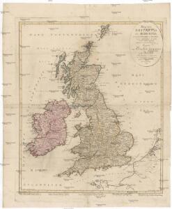
Magna Britannia et Hibernia
Velká Británie Walch, Johann Kitchin, Thomas J. Walch
Die britischen Inseln
Velká Británie Wyld, James Kitchin, Thomas
Gross-Britanien und Irland
Velká Británie Raffelsperger, Franz Kitchin, Thomas Franz Raffelsperger
Konigreich Grossbrittanien und Irland
Velká Británie Raffelsperger, Franz Kitchin, Thomas
Carte des trois royaumes d'Angleterre d'Ècosse et d'Irlande
Velká Británie Raffelsperger, Franz Kitchin, Thomas
[Velká Británie a Irsko]
Velká Británie Lotter, Tobias Conrad Lotter, Matthäus Albrecht
Magna Britannia complectens Angliae, Scotiae et Hiberniae regn. in suas prov. et comitat.
Velká Británie Seutter, Matthäus Vilém Oranžský per Homannum
Daniæ, Frisiæ, Groningæ et Orientalis Frisiæ littora
1 Karte : Kupferdruck ; 48 x 56 cm Renard apud L. Renard
[124][127] Daniae, Frisiae, Groningae et Orientalis Frisiae littora, uit: Atlas sive Descriptio terrarum orbis
Annotatie: Gedigitaliseerde versie. Amsterdam. Heiloo : Picturae (vervaardiger), 2015. tiff-bestand. Gedigitaliseerd: 07-01-2015; Origineel: Universiteitsbibliotheek Vrije Universiteit (XL.05127.-) ; Netherlands; Titelpagina ontbreekt Wit, Frederik de Amsterdam : Frederick de Wit
Nordwestl. Deutschland und Daenemark
[Allgemeiner Atlas über alle Theile der Erde in 29 Blättern] Ziegler, Jakob Melchior Top. Anstalt v. J. Wurster u. Comp.
Denmark, pt. of Norway.
1 : 1770000 Society for the Diffusion of Useful Knowledge (Great Britain)
Grossdeutsches Reich und angrenzende Gebiete

Operationen der alliirten und französischen Armee 1759

Denmark and part of Norway (Denmark, Norge)
1 : 2000000 Dánsko Walker, C. Baldwin & Cradock
Carte de la mer de Dannemark et des entrées dans la mer baltique
1 Karte : Kupferdruck ; 59 x 85 cm s.n.
The north west part of Germany.
1 : 2500000 Moll, Herman, d. 1732

Denmark, S. Norway.
1 : 1774080 Letts, Son & Co.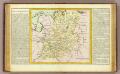
Westphalie.
1 : 1400000 Clouet, J. B. L. (Jean-Baptiste Louis), b. 1730
NW pt. of Germany.
1 : 2150000 Bowen, Emanuel
Hiberniae regnum
1 : 888000 Irsko Visscher, Nicolaus Vilém Oranžský per Nicolaum Visscher
Denmark.
1 : 1837440 Tallis, J. & F.
Denmark with Northwest portion of the German Empire
1 : 1332000 Johnston, Alexander Keith
Denmark with Northwest portion of the German Empire
1 : 1332000 Johnston, Alexander Keith
Le Cercle De Westphalie divisé en tous ses Estats et Souverainetés [Karte], in: Atlas nouveau, contenant toutes les parties du monde [...], Bd. 1, S. 295.
1 Karte aus Atlas Sanson, Nicolas Jaillot, Alexis Hubert und Mortier, Pieter
Denmark with Northwest portion of the German Empire
1 : 1332000 Johnston, W. & A.K.
Demarcations-Linie welche Kraft dem am 17. May 1795 zwischen Frankreich und Preussen geschlossenen Vergleich bestimmt : wie weit die Franzosen disseits des Rheins in Deutschland vordringen dürffen
1 : 1300000 Augsburg : Johann Walch
Nova et exacta mappa geographica exhibens circulum Westphalicum in omnes suos status et provincias accurate divisum
1 : 700000 Vestfálsko (Německo) Lotter, Tobias Conrad cura et sumptibus Tobiae Conrad Lotter
Nova et exacta mappa geographica exhibens circulum Westphalicum in omnes suos status et provincias accurate divisum
1 : 700000 Vestfálsko (Německo) Lotter, Tobias Conrad Tobiae Conrad Lotter