Maps of England

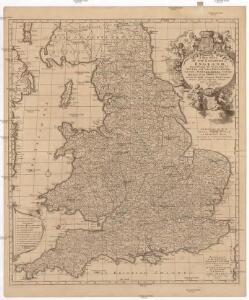
A new mapp of the kingdome of England
Anglie Overton, John by Nicolas Visscher

England
1 : 1380000 Anglie Weiland, Karl Ferdinand Maedel, Carl Jos. Geograph. Institut
England
1 : 1380000 Anglie Weiland, Karl Ferdinand Maedel, Carl Jos. Geograph. Institut
Magnae Britanniae pars meridionalis in qua regnum Angliae tam in septem antiqua Anglo-Saxonum regna quam in omnes hodiernas regiones accurate divisum hic ostenditur quam tabula ab archetypo Vischeriano desumptam
1 : 1300000 Anglie Homann, Johann Baptist Ioh. Bapt. Homan[n]
Geological map England, Wales.
1 : 1774080 Letts, Son & Co.
Railway, statistical England, Wales.
1 : 1774080 Letts, Son & Co.
England and Wales.
1 : 2700000 Lucas, Fielding Jr.
The Inland Navigation, Rail Roads, Geology and Minerals of England & Wales.
1 : 1090000 Arrowsmith, John
ANGLIA REGNUM IN OMNES SUOS DUCATUS, COMITATUS ET P[ROVINCIAS DIVISUM]
1 : 2300000 Anglie Wit, Frederik de F. de Wit
England, Wales.
1 : 1800000 Flemming, Carl
Britanniae sive Angliae regnum
1 : 1300000 Anglie Lotter, Tobias Conrad sumtibus Tob. Conradi Lotter

England and Wales.
1 : 1725000 Teesdale, Henry
Geological map of England and Wales / publ. under the superintendence of the Society for the Diffusion of Useful Knowledge ; arr. by Roderick Impey Murchison ; S.P. Woodward del.; cold. by T. Malby; J. & C. Walker sculpt
1 : 1780000 Annotatie: Oorspr. uitg.: Strand : Chapman and Hall, 1843; Annotatie geografische gegevens: Met aanvullingen tot 1847 Roderick Impey Murchison 1792-1871; S.P. Woodward; T. Malby; Society for the Diffusion of Useful Knowledge London : Knight
England.
1 : 1090000 Arrowsmith, John
County Map Of England, And Wales.
1 : 2400000 Mitchell, Samuel Augustus
Ordnance survey map of XVII century England
1 : 1000000 Anglie Ordnance Survey Office
Smith's new map of England and Wales with parts of Scotland : including the turnpike, and principal crossroads ... / engraved by Edw[ar]d Jones & Benj[ami]n Smith
1 : 1275000 Jones, Edward (fl. 1806); Smith, Benjamin London : C. Smith

England And Wales.
1 : 2850000 Finley, Anthony
England, Wales.
1 : 1480000 Hall, S. (Sidney)
Composite: (Cary's England, Wales, and Scotland).
1 : 360000 Cary, John, ca. 1754-1835
England.
1 : 1050000 Thomson, John
England & Wales.
1 : 1013760 Stanford, Edward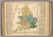
Kingdoms of the Anglo-Saxons.
Lavoisne, M.
Britannia
1 : 1300000 Anglie Reichard, Christian Gottlieb Campius, D. a D. Campio
Anglia in septem Anglo-Saxonum regna omnesque hodiernas regiones ordine distincta
1 : 1400000 ededit Petrus Schenk [Amsterdam : Petrus Schenk]
Britanniae sive Angliae Regnum, tam secundum prisca Anglo-Saxonum Imperia, quam recentiorem Provinciarum divisionem accuratissime designatum
1 : 1300000 studio et sumptibus Tob. Conradi Lotter, Chalgogr. et Geogr. Augustani. [Augsburg] : [Tob. Conrad. Lotter]
England canals, railways.
1 : 1730000 Society for the Diffusion of Useful Knowledge (Great Britain)