Maps of Bergen auf Rügen

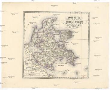
Reise Karte von der Insel Rügen
Rujana (Německo) Hagenow, Friedrich von Janssonius, Johannes
Rvgia insvla ac dvcatvs
1 : 270000 Rujana (Německo) Lubin, Eilhard Janssonius, Johannes Ioannis Ianßonius
Rügen


Composite: 64. Bergen a. Rugen. (Germany)
1 : 100000 Reichsamt fur Landesaufnahme
64. Bergen a. Rugen. (Germany)
1 : 100000 Reichsamt fur Landesaufnahme
Rugia Insula Ac Ducatus
1 : 240000 Mollova mapová sbírka Lubin, Eilhard Covens, Johannes I
Rugia Insula Ac Ducatus
1 : 265000 Mollova mapová sbírka Lubin, Eilhard Schenk, Peter I
Rugia Insula Ac Ducatus
1 : 240000 Mollova mapová sbírka Lubin, Eilhard Blaeu, Joan I.
Rugia Insula Ac Ducatus
1 : 525000 Mollova mapová sbírka Merian, Matthäus Merian, Matthäus
Rugia Insula Ac Ducatus
1 : 265000 Mollova mapová sbírka Lubin, Eilhard Janssonius, Johannes I
Composite: 42. Sagard. (Germany)
1 : 100000 Reichsamt fur Landesaufnahme
Composite: 41. Wiek auf Rugen. (Germany)
1 : 100000 Reichsamt fur Landesaufnahme
63. Stralsund. (Germany)
1 : 100000 Reichsamt fur Landesaufnahme
Composite: 63. Stralsund. (Germany)
1 : 100000 Reichsamt fur Landesaufnahme
41. Wiek auf Rugen. (Germany)
1 : 100000 Reichsamt fur Landesaufnahme
Meßtischblatt 375 : Vilmnitz, 1898
1 : 250000 Vilmnitz. - Aufn. 1885, hrsg. 1887, einz. Nachtr. 1898. - 1:25000. - [Berlin]: Reichsamt für Landesaufnahme, 1898. - 1 Kt.
Meßtischblatt 374 : Putbus, 1886
1 : 250000 Putbus. - Aufn. 1885, hrsg. 1887. - 1:25000. - [Berlin]: Reichsamt für Landesaufnahme, 1886. - 1 Kt.
Meßtischblatt 373, neue Nr. 1645 : Samtens, 1886
1 : 250000 Samtens. - Aufn. 1885, hrsg. 1886. - 1:25000. - [Berlin]: Reichsamt für Landesaufnahme, 1886. - 1 Kt.
Meßtischblatt 372, neue Nr. 1644 : Stralsund, 1886
1 : 250000 Stralsund. - Aufn. 1885, hrsg. 1886. - 1:25000. - [Berlin]: Reichsamt für Landesaufnahme, 1886. - 1 Kt.
Meßtischblatt 316 : Lubkow, 1925
1 : 250000 Lubkow. - Aufn. 1885, bericht. 1925. - 1:25000. - [Berlin]: Reichsamt für Landesaufnahme, 1925. - 1 Kt.
Meßtischblatt 1546 : Bergen (auf Rügen), 1936
1 : 250000 Bergen (auf Rügen). - Hrsg. 1887, bericht. 1925. - 1:25000. - [Berlin]: Reichsamt für Landesaufnahme, 1936. - 1 Kt.
Meßtischblatt 1545 : Gingst, 1936
1 : 250000 Gingst. - Hrsg. 1887, bericht. 1925. - 1:25000. - [Berlin]: Reichsamt für Landesaufnahme, 1936. - 1 Kt.
Meßtischblatt 313, neue Nr. 1544 : Klausdorf, 1937
1 : 250000 Klausdorf. - Hrsg. 1886, bericht. 1925. - 1:25000. - [Berlin]: Reichsamt für Landesaufnahme, 1937. - 1 Kt.
Meßtischblatt 260, 261 : Sagard, 1920
1 : 250000 Sagard. - Aufn. 1885, Nachtr. 1920. - 1:25000. - [Berlin]: Reichsamt für Landesaufnahme, 1920. - 1 Kt.
Meßtischblatt 259 : Rappin, 1936
1 : 250000 Rappin. - Hrsg. 1886, bericht. 1925. - 1:25000. - [Berlin]: Reichsamt für Landesaufnahme, 1936. - 1 Kt.
Meßtischblatt 258, neue Nr. 1445 : Trent, 1936
1 : 250000 Trent. - Hrsg. 1886, bericht. 1925. - 1:25000. - [Berlin]: Reichsamt für Landesaufnahme, 1936. - 1 Kt.
Meßtischblatt 257, 211 : Kloster, 1914
1 : 250000 Kloster. - Aufn. 1885, hrsg. 1886, Aufldr. 1914. - 1:25000. - [Berlin]: Reichsamt für Landesaufnahme, 1914. - 1 Kt.
Meßtischblatt 1346 : Altenkirchen, 1932
1 : 250000 Altenkirchen. - Hrsg. 1886, bericht. 1924, letzte Nachtr. 1932. - 1:25000. - [Berlin]: Reichsamt für Landesaufnahme, 1932. - 1 Kt.