Maps of Indian Ocean

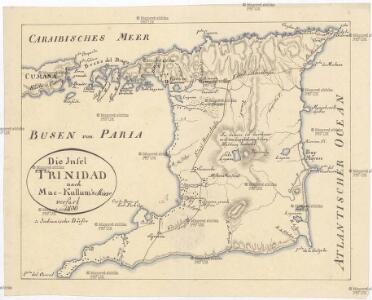
Die Insel Trinidad
Trinidad a Tobago Martius, C. von Mac-Cullum
The East Indies, with the roads (southern section).
1 : 2600000 Jefferys, Thomas
Arabien.
1 : 9400000 Radefeld, Carl Christian Franz, 1788-1874
Arabia et Arabicus sinus
1 : 5700000 Arabský poloostrov Reichard, Christian Gottlieb Campius, D. a D. Campio
Arabia
1 : 11000000 Arrowsmith, Aaron Jr.
Arabia.
1 : 13800000 Darton, William
Composite: East Indies with roads.
1 : 2600000 Jefferys, Thomas
Stanford's Map Of India.
1 : 2217600 Stanford, Edward
Composite: Hindoostan.
1 : 2500000 Robert Laurie & James Whittle
Arabien
1 : 23188000 Arabský poloostrov Schlieben Gleditsch
Arabien, Ägypten, Nubien und Habesch
Schul-Atlas in 36 Karten Völter, Daniel Verlag der J.M. Dannheimer'schen Buchhandlung
Charte von Hindostan und der Halbinsel
1 Karte : Kupferdruck ; 53 x 69 cm Mannert; Rennell; Pringle; Dirom; Campbell A.G. Schneider und Weigelsche Kunst- und Buchhandlung
Charte von Hindostan und der Halbinsel
1 Karte : Kupferdruck ; 52 x 68 cm Mannert; Rennell; Pringle; Dirom; Campbell A.G. Schneider und Weigelsche Kunst- und Buchhandlung
Charte von Hindostan und der Halbinsel
1 Karte : Kupferdruck ; 52 x 69 cm Mannert; Rennell; Pringle; Dirom; Campbell A.G. Schneider und Weigelsche Kunst- und Buchhandlung
Hindostan.
1 : 8500000 Lizars, Daniel
Delineatio omnium orarum totius australis partis Americae, dictae Peruvianae, a R. de la Plata, Brasiliam, Pariam, & Castellam auream, una cum omnibus insulis Antillas dictis, Hispaniolam, item & Cubam comprehendentis, usq[ue] ad promont. Floridae, vulgo cabo de la Florida, item isthmi inter Panamam & Nombre de dios, terrae Peru auriferae, cum ejus metropoli Cusco & com[m]odissimo portu Limae. orarum etiam Chilae, freti inter terram Patagonum, & terram del fuego, vulgo Estre
Jižní Amerika Langren, Arnoldus Florentius De Laet, Johannes
Persia, Arabia, &c.
1 : 10600000 Mitchell, Samuel Augustus
Persia, Arabia, &c.
1 : 10600000 Mitchell, Samuel Augustus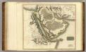
Arabia, Egypt, Abyssinia, Red Sea.
1 : 6500000 Thomson, John
134-135. India, Pakistan, Ceylon, Nepal, Political. The World Atlas.
1 : 7500000 USSR (Union of Soviet Socialist Republics).
India
1 : 15000000 J.W. Clement Co.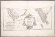
Prémière partie de la carte d'Asie : contenant la Turquie, l'Arabie, la Perse, l'Inde en deçu du Gange et de la Tartarie ce qui est limitrophe de la Perse et de l'Inde / par le Sr. d'Anville ; gravé par Guill. de-la-Haye
1 : 6650000 Annotatie: In: [Atlas du Sr. d'Anville], bl. 1 Anville, Jean Baptiste Bourguignon d'; Haye, Guill. de la A Paris : chez l'auteur
Tabula Asiae X. [Karte], in: Claud. Ptolemaeus. Geographia lat. cum mappis [...], S. 323.
1 Karte aus Atlas Münster, Sebastian [und Ptolemaeus, Claudius]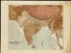
The Indian Empire and Ceylon
1 : 7500000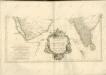

Nova Persiae Armeniae Natoliae et Arabiae descriptio
1 : 92500000 per F. de Wit t'Amsterdam : by Frederick de Wit inde Kalverstraet inde Witte Pascaert
Carte d'une partie des Indes orientales, estats du Mogol les côtes de Malabar et de Coromandel &c
1 : 14000000 Himálaj-oblast par Cóvens et Mortier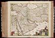
Nova Persiae Armeniae Natoliae et Arabiae descriptio / per F. de Wit
1 : 9250000 Annotatie: Origineel is Blad 180 in atlas factice; Annotatie geografische gegevens: Schaalstok op kaart: 75 Milliaria Germanica communia (=6 cm), en Gemeene Duytsche Mylen van 15 in een Graedt (=6 cm) Frederick de Wit 1630-1706 t'Amsterdam : by Frederick de Wit inde Kalverstraet inde Witte Pascaert
Inde. Asie Centrale.
1 : 10806700 Migeon, J.