Maps of Chukot

Charte von America
Amerika Kitschin, Thomas Berra, Marco
Imperium Russicum
1 : 7600000 Rusko Doetsch, Johann Anton Hartl, Sebastian apud Sebastianum Hartl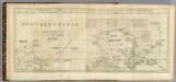
Chart containing part of the Icy Sea ... Greenland ... Islands about Baffins Bay and part of Hudsons Bay.
1 : 21000000 Jefferys, Thomas
Carte marine de la mer glaciale avec une partie de la province de Jrkucki
1 Karte : Kupferdruck ; 42 x 48 cm Academie roÿale des sciences
Charte von America
1 Karte : Kupferdruck ; 58 x 48 cm Walch bey Johannes Walch
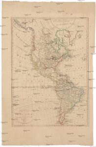
America
Amerika Schmidt, Johann Marius Friedrich Franz Simon Schropp et Co.
Carte marine de la mer glaciale, et la Siberie septentrional
1 Karte : Kupferdruck ; 42 x 48 cm Königliche Akademie der Wissenschaften
CHARTE vom ASIATISCHEN RUSSLAND
Rusko východní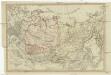
Charte vom Asiatischen Russland
Rusko východní
Russia asiatica
1 : 13000000 1 Karte : Kupferdruck ; 42 x 30 cm presso Antonio Zatta, e figli
Carte Generale de la Russie d'Asie ou Siberie.
1 : 14300000 Vivien de St Martin, L.
General'naja karta azijatskoj časti Rossijskoj imperii
1 : 26000000 Rusko východní Korsakov, P.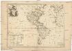
L'Amerique
Amerika Le Rouge, Georges-Louis Charlevoix, Pierre-François-Xavier de Le Rouge
America 1841
Amerika Martius, C. von Arrowsmith, John Verlag der geographischen Anstalt des Bibliographischen Instituts
Tartarie septentrionale et orientale suivant Monsr. Witsen et les meilleures relations
1 : 10000000 A Amsterdam : chez Jean Fred. Bernard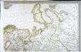
Carte d'Europe ou sont tracées les limites des empires, royaumes, et etats souverains, feuille 2
1 Blatt : 63 x 95 cm Semen etc
34-35. Siberia, Middle. The World Atlas.
1 : 5000000 USSR (Union of Soviet Socialist Republics).
Nova Zemla, Wygats, Fretum Naßovicum, et Terra Samoiedum singula omnium emendatißimè descripta. [Karte], in: Novus atlas absolutissimus, Bd. 9, S. 171.
1 Karte aus Atlas Janssonius Offizin
Nova Zembla, Waygats, Fretum Naßovicum, et Terra Samoiedum [...] [Karte], in: Het vijfde Deel Des Grooten Atlas : Vervatende De Water-Weereld, S. 126.
1 Karte aus Atlas Jansson, Jan Jansson, Jan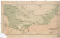
Cesta norské výpravy na severní točnu 1893-1896
1 : 12000000 Arktida nákladem J. Otty
Russie occidentale.
1 : 13000000 Bonne, Rigobert, 1727-1794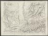
Russiae, vulgo Moscovia dictae, Partes Septentrionalis et Orientalis. [Karte], in: Theatrum orbis terrarum, sive, Atlas novus, Bd. 1, S. 74.
1 Karte aus Atlas Blaeu, Joan Blaeu, Willem Janszoon
Rvssiæ, vulgo Moscovia dictæ, partes septentrionalis et orientalis
1 : 5100000 1 Karte : Kupferdruck ; 40 x 53 cm Jansson, Jan apud Janssonio-Waesbergios
Rvssiæ, vulgo Moscovia dictæ, partes septentrionalis et orientalis
1 : 5100000 1 Karte : Kupferdruck ; 40 x 53 cm Blaeu, Joan Apud Ioannem et Cornelium Blaeu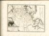
Suite de la carte de la Sibérie et le pays de Kamtschatka
1 : 14500000 1 Karte : Kupferdruck ; 23 x 25 cm [Bellin]
Suite de la carte de la Sibérie et le pays de Kamtschatka
1 : 14500000 1 Karte : Kupferdruck ; 23 x 25 cm [Bellin]
Partie occidentale de l'empire de Russie / projetée et assujetie aux observations astronomiques pos
1 : 13000000 1 Karte : Kupferdruck ; 42 x 31 cm Bonne, Rigobert chez Lattré ruë St. Jacques à la ville de Bordeaux
Russia, divided into its governments / by Samuel Dunn, Mathematician
1 : 12000000 1 Karte : Kupferdruck ; 30 x 44 cm Dunn, Samuel Printed for Robt. Sayer, No. 53 Fleet Street