Maps of Chukot

[Východní Asie].
Asie východní Berghaus, Heinrich Karl Wilhelm Horsburgh, James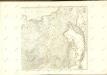
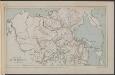
Map of the Amur Region
Russland Sibirien Amur Philip, George ; Philip, [Sohn v. G.]
Suite de la carte de la Sibérie et le pays de Kamtschatka
1 : 14500000 1 Karte : Kupferdruck ; 23 x 25 cm [Bellin]
Suite de la carte de la Sibérie et le pays de Kamtschatka
1 : 14500000 1 Karte : Kupferdruck ; 23 x 25 cm [Bellin]
General'naja karta azijatskoj časti Rossijskoj imperii
1 : 26000000 Rusko východní Korsakov, P.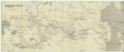
Azijatskaja Rossija
1 : 10500000 Rusko východní
Russia asiatica
1 : 13000000 1 Karte : Kupferdruck ; 42 x 30 cm presso Antonio Zatta, e figli
Ice Chart, Okhotsk Sea Region, February.
U.S. Navy
Ice Chart, Okhotsk Sea Region, July.
U.S. Navy
Ice Chart, Okhotsk Sea Region, December.
U.S. Navy
Ice Chart, Okhotsk Sea Region, May.
U.S. Navy
Ice Chart, Okhotsk Sea Region, October.
U.S. Navy
Ice Chart, Okhotsk Sea Region, April
U.S. Navy
Teatr voennych dějstvīj v 1904 - 1905 godach
China Russisch-Japanischer Krieg
Schema historických momentů československ. vojenských operací na Sibiři 1918-1919

Ice Chart, Okhotsk Sea Region, January.
U.S. Navy
Ice Chart, Okhotsk Sea Region, November.
U.S. Navy
Schema historických momentů československ. vojenských operací na Sibiři 1918-1919

Russia in Asia 3, Chinese Empire.
1 : 10454400 Letts, Son & Co.
Schema historických momentů československ. vojenských operací na Sibiři 1918-1919

Ice Chart, Okhotsk Sea Region, March.
U.S. Navy
Ice Chart, Okhotsk Sea Region, June.
U.S. Navy
Ice Chart, Okhotsk Sea Region, August.
U.S. Navy
Siberia, Chinese Tartary.
1 : 11000000 Society for the Diffusion of Useful Knowledge (Great Britain)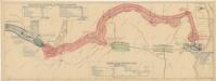
Schema historických momentů československ. vojenských operací na Sibiři 1918-1919

Manchuria
1 : 4000000 Mandžusko (Čína) War Office
Manchuria
1 : 4000000 Mandžusko (Čína) Royal Geographical Society
34-35. Siberia, Middle. The World Atlas.
1 : 5000000 USSR (Union of Soviet Socialist Republics).
![[Východní Asie].](https://images-2.georeferencer.com/images/iiif/379115469926/full/,300/0/native.jpg)

