Maps of Dejvice

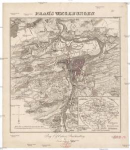
Prag's Umgebungen
Praha-oblast (Česko) Scheiner, Josef Kettner, C. J.G. Calve'sche Buchhandlung
Výškopisný plán hlavního města Prahy s okolím
1 : 20000 Praha (Česko) obec Pražská
Regulační plán Velké Prahy s okolím
1 : 50000
Nový, úředně schválený plán Velké Prahy
1 : 25000
Belagerung der königlicher Haupt-Stadt Prag...
Jižní Město. - Litochleby Orientační plán 3. souboru
1 : 2500
Jižní Město. - Opatov Orientační plán 2. souboru
1 : 2500
Okolí města Prahy na hodinu cesty
Praha-oblast (Česko) K. Hübner
Jižní Město. - Háje Orientační plán 1. souboru
1 : 3500
Uliční mapa hlavního města Prahy

Specielle Telegrafen und Eisenbahn Karte von Böhmen

Plan van de stadt en de beleegering van Praag, 1757 = Plan de la ville & du siege de Prague, en 1757
T. Otten sc. ['s-Gravenhage] : P. Gosse excudit
Orientační plán hlavního města Prahy s okolím

Přehledná mapa Velké Prahy
1 : 35000 Praha (Česko : oblast) Brož, Josef A. Storch syn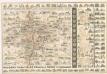
Praha : názorné plány a rejstřík

Hlavní město Praha
1 : 55000 Praha (Česko)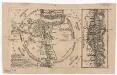
Grundriss der könig. böhmische[n] Haupt Stadt Prag
Praha (Česko)
Verbesserter Grundriß der königl. bohmischen Haupt Stadt Prag mit der königl. ungarschen Belagerung und Attaquen A 1742
Praha (Česko) Riegel, Christoph bey Christoph Riegel
Grundriß der königl. bohmischen Haupt Stadt Prag mit der königl ungarschen Belagerung und Attaquen A 1742
Praha (Česko)
Grundriss der König. Bohmischen Haupt Stadt Prag
Praha (Česko) Christoph Riegel Buchhändlen
Prag und seine Umgebungen, nach den besten Hülfsmitteln dargestellt
1 : 42000 C. Kettner sculp. Prag : J. G. Calve'sche Buchhandlung
Plán velké Prahy
1 : 19000 Praha (Česko) Grgurič, Václav Sádlo, Jiří A. Storch syn
Plán Velké Prahy
1 : 19000
Městské podniky Pražské
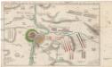
Accurate Vorstellung der zwischen den oesterreichischen und preussischen Armeen geschehenen Bataille bey Prag, den 6. May 1757
Praha (Česko)
Plan der Hauptstadt Prag und der umliegenden Gegend sammt dem Lustlager der kais. königl. Armée
1 : 47500 Praha (Česko)
Plan der Hauptstadt Prag und der umliegenden Gegend sammt dem Lustlager der kais. königl. Armée
1 : 47500 Praha (Česko)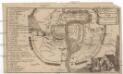
Plan der Merckwürdrgen [sic] Belagerung der Stadt Prag in Böhmen Anno 1743
Praha (Česko)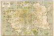
Orientační plán hlavního města Prahy
1 : 14000