Maps of okres Chomutov

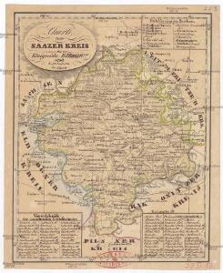
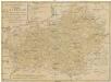
Charte vom Saazer Kreis im Königreiche Böhmen
Žatec-oblast (Louny, Česko) Berghaus, Heinrich Karl Wilhelm Kutschera, E. E. Kutschera
Der Satzer Creis in dem Königreiche Böhmen gelegen
1 : 530000 Karlovarský kraj (Česko) Schreiber, Johann Georg Joh. George Schreibers see. Wittbe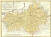
Regni Bohemiae Circulus Satecensis
1 : 225000 Mollova mapová sbírka Müller, Johann Christoph Homann, Johann Baptista - dědici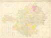
Žatecký kraj, mapa podle panství
Regni Bohemiae circulus Satecensis
1 : 220000 Žatec-oblast (Louny, Česko) Müller, Johann Christoph editus curis Homannianorum Heredum
Regni Bohemiae circulus Satecensis
1 : 220000 Žatec-oblast (Louny, Česko) Müller, Johann Christoph editus curis Homannianorum Heredum
Regni Bohemiae circulus Satecensis
1 : 220000 Žatec-oblast (Louny, Česko) Müller, Johann Christoph editus curis Homannianorum Heredum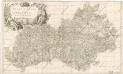
Regio Egrana et A. Provincia Satecensis

Special-Karte des Saazer Kreises
1 : 210000 Žatec-oblast (Louny, Česko) Schmidt, Eduard C.W. Medau
Special-Karte des Saazer Kreises
1 : 210000 Žatec-oblast (Louny, Česko) Schmidt, Eduard C.W. Medau
Special-Karte des Saazer Kreis, resp. polit. Verwaltungsbezires nach der politischen Eintheilung Böhmens v. Jah. 1868
1 : 220000 Žatec-oblast (Louny, Česko) Schmidt, Eduard Wend. Morauer
Special-Karte des Saazer Kreis - resp. politischen Verwaltungsbezirkes
1 : 220000 Žatec-oblast (Louny, Česko) Schmidt, Eduard W. Morauer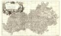
Regio Egrana et Provincia Satecensis
1 : 233000 Mollova mapová sbírka Erber, Bernardinus Winkler, Johann Christoph Kurzböck, Josef von
Karte des Saazer Kreises im Koenigreiche Boehmen
Žatec-oblast (Louny, Česko) Wostrý, Karl Ferd. Ritt. von Schönfeld's Witwe et Comp.
Karte des Saazer Kreises im Königreiche Böhmen
1 : 145000 Žatec-oblast (Louny, Česko) Wostrý, Karl Malik. Aug. Ferdinand Ritter
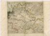
Charte vom Saatzer Kreise des Königreichs Böheim
1 : 240000 Žatec-oblast (Louny, Česko) Kreibich, František Jakub Jindřich C. W. Enders
Charte vom Saatzer Kreise des Königreichs Böheim
1 : 240000 Žatec-oblast (Louny, Česko) Kreibich, František Jakub Jindřich Enders, C. W. C.W. Enders
Charte vom Saatzer Kreise des Königreichs Böheim
1 : 240000 Žatec-oblast (Louny, Česko) Kreibich, František Jakub Jindřich Enders, C. W. C.W. Enders
Charte vom Saatzer Kreise des Königreichs Böheim
1 : 240000 Žatec-oblast (Louny, Česko) Kreibich, František Jakub Jindřich Enders, C. W. C.W. Enders
Charte vom Saatzer Kreise des Königreichs Böheim
1 : 240000 Žatec-oblast (Louny, Česko) Kreibich, František Jakub Jindřich Enders, C. W. C.W. Enders
Charte vom Saatzer Kreise des Königreichs Böheim
1 : 240000 Žatec-oblast (Louny, Česko) Kreibich, František Jakub Jindřich Rainold, Karl Eduard C.E. Rainold
Charte vom Saatzer Kreise des Königreichs Böheim
1 : 240000 Žatec-oblast (Louny, Česko) Kreibich, František Jakub Jindřich Rainold, Karl Eduard C.E. Rainold
Charte vom Saatzer Kreise des Königreichs Böheim
1 : 240000 Žatec-oblast (Louny, Česko) Kreibich, František Jakub Jindřich C. E. Rainold
Charte vom Saatzer Kreise des Königreichs Böheim
1 : 240000 Žatec-oblast (Louny, Česko) Kreibich, František Jakub Jindřich Rainold, Karl Eduard C.E. Rainold
Charte vom Saatzer Kreise des Königreichs Böheim
1 : 240000 Žatec-oblast (Louny, Česko) Kreibich, František Jakub Jindřich Rainold, Karl Eduard C.E. Rainold
Charte vom Saatzer Kreise des Königreichs Böheim
1 : 240000 Žatec-oblast (Louny, Česko) Kreibich, František Jakub Jindřich C. E. Rainold
Charte vom Saatzer Kreise des Königreichs Böheim
1 : 240000 Žatec-oblast (Louny, Česko) Kreibich, František Jakub Jindřich Rainold, Karl Eduard C.E. Rainold
Die Verschiebung der nationalen Schichtung der Bevölkerung in Nordwest-Böhmen von 1880 bis 1930
Čechy severozápadní (Česko) Deutscher Kulturverband
Monumenta Cartographica Bohemiae II.: Müllerova mapa