Maps of Turkey

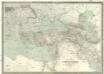
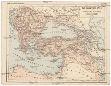
Das Osmanische Reich nach seiner größten Ausdehnung im XVII. Jahrhundert.
osmanská říše Benecke Bormann, E. F. Tempsky
Das Osmanische Reich nach seiner grössten Ausdehnung im XVIIten Jahrhundert
1 : 12000000 Osmanisches Reich
La mer Mediterranée vers l'orient
1 Karte : Kupferdruck ; 38 x 49 cm Duval P. Duval
Empire Ottoman.
Andriveau-Goujon, J.
Carte du théatre de la guerre
Asie jihozápadní Andriveau-Goujon, Eugene Monrocq
Map of the Ottoman Empire, Kingdom of Greece, and the russian provinces on the Black Sea
1 : 5900000 balkánské země Dower, John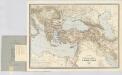
Carte générale des provinces européennes et asiatiques de l'Empire Ottoman, uit: Carte générale des provinces européennes et asiatiques de l'Empire Ottoman (sans l'Arabie) / dressée par Henri Kiepert ; le trait et la lettre gravés chez L. Kraatz ; le figure du terrain gravé par J. Sulzer
1 : 3000000 Annotatie: Op omslag ook: Deuxième édition entièrement corrigée et augmentée d'un index alphabétique (quatrième édition de la 'Carte générale de l'Empire Ottoman en Europe et en Asie'); Met: Index alfabétique. - 40 p; Annotatie geografische gegevens: Legenda Johann Samuel Heinrich Kiepert 1818-1899; Leopold Kraatz; J. Sulzer Berlin : Dietrich Reimer (Hoefer u. Vohsen) / ([S.l. : L. Kraatz])
Balkánské státy a Turecko
1 : 3000000 Bospor (Turecko : průliv) Paulík, Ant. Klus, František Ústřední učitelské nakladatelství a knihkupectví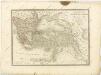

The Turkish empire in Europe and Asia with the Kingdom of Greece
1 : 8400000 Blízký východ Walker, C. Society for the diffusion of useful knowledge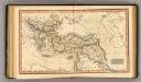
Ottoman Empire.
1 : 14100000 Fenner, Rest.
[Ethnographische Karte von Europa]
Zweiter Band, enthaltend in vier Abtheilungen die Vertheilung der Organismen: 5. Pflanzen-Geographie, 6. Thier-Geographie, 7. Anthropographie, 8. Ethnographie Humboldt, Alexander von Verlag von Justus Perthes
Südeuropa
1 : 2500000 Blízký východ Gea Verlag
Uebersichts Karte des russisch - türkischen Kriegsschauplatzes in Europa und Asien
General-Karte des Türkischen Reiches in Europa und Asien nebst Ungarn, Südrussland, den kaukasischen Ländern und West-Persien
1 : 3000000 entworfen und bearb. von Heinrich Kiepert Stich und Druck der lithographischen Anstalt von L. Kraatz Berlin : Reimer
Tooneel van den oorlog in het Oosten / Top. Bureau, Min. van Oorlog
1 : 3000000 Annotatie geografische gegevens: Met 2 schaalstokken Ministerie van Oorlog. Topographisch Bureau ['s-Gravenhage : Top. Bureau, Min. van Oorlog]
Übersichts - Karte des Türkischen Reichs in Europa und Asien
Turkish Empire.
1 : 5702400 Fullarton, A. & Co.
Tooneel van den oorlog in het Oosten
1 : 3000000 Top. Bureau, Min. van Oorlog ['s-Gravenhage] : Top. Bureau, Min. van Oorlog
Europaeische und asiatische Türkey
1 : 7100000 Blízký východ Mollo, Tranquillo T. Mollo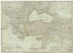
Europaeische und asiatische Türkey
1 : 7100000 Evropa jihovýchodní Mollo, Tranquillo Tranquillo Mollo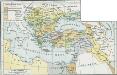
Osmanisches Reich bis 1683
1 : 18000000 Osmanisches Reich Expansion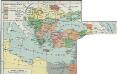
I. Osmanisches Reich bis 1683
1 : 28000000 Osmanisches Reich Expansion
Turcia Asiatica : exhibens Natoliam modernam, in suos beglirbegatus divisam, itemque reliquos beglirbegatus, sive gubernationes et Prœfecturas generales, in regionibus Georgiæ, Armeniæ, Mespotamiæ, Syriæ et Arabiæ sitos, una cum Mari Nigro, Mari Azowiensi, Mari di Marmora, et Mari Ægeo, atque adiacentibus Insulis : C. P. S. C. M. = Carte de la Turquie asiatique contenant la Natolie moderne divisée en les beglerbeys &
1 : 4800000 Homann Erben (Firm) Homannianorum Heredum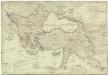
Europaeische und asiatische Türkey
1 : 4250000 Blízký východ Mollo, Tranquillo T. Mollo
Partie orient.le de la mer Méditerranée
1 Karte : Kupferdruck ; 49 x 55 cm Robert de Vaugondy chés l'auteur quay de l'horloge du Palais près le pont neuf
Turkish Empire, Greece.
1 : 7200000 Society for the Diffusion of Useful Knowledge (Great Britain)
Europa befolkningskarta

Zuid-oostelijk oorlogsterrein
1 : 6000000 Annotatie geografische gegevens: Op de kaart zijn vestingen en forten aangegeven 's-Gravenhage : Smulders