Maps of Czech Republic

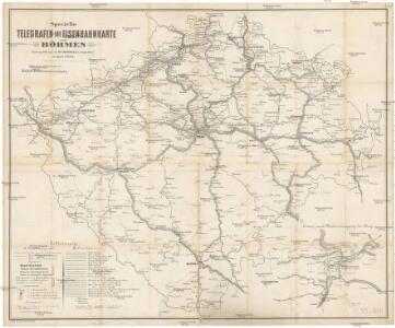
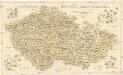
Specielle Telegrafen- und Eisenbahnkarte von Böhmen
1 : 421000 Čechy (Česko) Hollmann, Jos. Jos. Hollmann
Specielle Telegrafen- und Eisenbahnkarte von Böhmen
Čechy (Česko) Hollmann, Jos. Taafe, Ludvík Friedrich Ehrlich
Čechy, Morava a Slezsko
Morava (Česko) Studnička, Alois Karel Janský
[Protektorát Čechy a Morava]
1 : 400000 Protektorát Čechy a Morava Machát, František
Mapa doktorů a absolv. techniků s 2. stát. zkouškou od r. 1882-83 do 1892-93
Česko Horák, František Doležal, Bohumil
Mapa relativních přebytků a nedostatků normálních srážek
Česko Státní ústav hydrologický T. G. Masaryka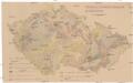
Mechanisch-physikalische Bodenkarte der Sudetenländer
1 : 750000 Česko Niethammer, A.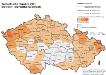
Tschechische Republik 2001. Slowaken (slovenská národnost)
Tschechische Republik ethnische Gruppe, Slowaken Hofinger, Veronika
Viseci [sic] mapa Království českého
1 : 200000 Česko Kocen, Blaž Erben, Josef Eduarda Hölzel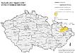
Tschechische Republik 2001. Schlesier (slezská národnost)
Tschechische Republik ethnische Gruppe, Schlesier Hofinger, Veronika
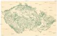
Soubor němých map pro střední školy
Kulturní mapa země České a Moravskoslezské
1 : 530000 Brno (Česko) Lauda, Ladislav Šolc a Šimáček
[Slepá mapa Česka]
1 : 752000 Česko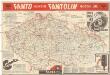
Mapa o stavu vozovek československých silnic
1 : 650000 Česko Autoklub RČS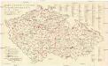
Mapa o stavu vozovek československých silnic
1 : 650000 Česko Autoklub R.Č.S.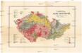
Přehledná mapa geologická zemí Koruny české
Česko Woldřich, Jan Nepomuk Frant. Bačkovský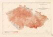
Isotermy v zemi České a Moravskoslezské
Mapa akadem. spolků a jejich knihovny
Česko Amler, J. Horák, F.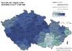
Tschechische Republik 2001. Tschechen (česká národnost)
Tschechische Republik ethnische Gruppe, Tschechen Hofinger, Veronika
Dr. A. Oberschall's Sprachenkarte der Tschechoslowakischen Republik.
Česko Oberschall, Albin Hocke, Jan Deutschpolitischen Arbeitsstelle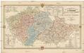
Montanistische Geschäftskarte von Böhmen, Mähren und Öster. Schlesien
1 : 650000 Česko Schmidt, Johann Ferdinand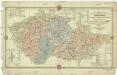
Montanistische Geschäftskarte von Böhmen, Mähren und Öster. Schlesien
1 : 660000 Česko Schmidt, Johann Friedrich Julius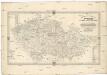
Montanistische Geschäftskarte von Böhmen, Mähren und Öster. Schlesien
1 : 650000 Česko Schmidt, Johann Ferdinand Taafe, Ludvík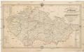
Montanistische Geschäftskarte von Böhmen, Mähren und Öster. Schlesien
Česko Schmidt, Johann Ferdinand Taafe, Ludvík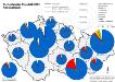
Tschechische Republik 2001. Nationalitäten
Tschechische Republik ethnische Gruppe Hofinger, Veronika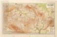
Grossdeutsches Reich Sudetenländer
Waldkarte der Sudetenländer
1 : 750000 Sudety (Česko) Heller, Johann Geographisches Institut der Deutschen Universität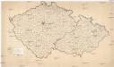
[Waldkarte der Sudetenländer]
1 : 750000 Sudety (Česko) Heller, Johann Geographisches Institut der Deutschen Universität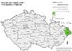
Tschechische Republik 2001. Polen (polská národnost)
Tschechische Republik ethnische Gruppe, Polen Hofinger, Veronika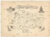
Ústřední matice školské mapa škol a místních odborů v zemích Koruny české
1 : 525000 Česko Šlechta, Jan Vilím, J.