Maps of Romania

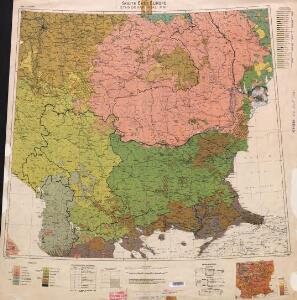
Ethnographical map (Eastern Europe). South East Europe 1918
1 : 1500000 First World War ethnographical map (Eastern Europe). 1918. Four sheets, covering Germany, Poland, Northern Italy and South eastern Europe. To illustrate the post-WW1 settlement. War Office
Übersichtskarte der Kriegsschauplatzes vom Jahre 1877 / 78

S.E. East Europe, Roumania, Turkey, Servia.
1 : 2977920 Letts, Son & Co.
Ancient Macedonia, Thracia, Illyria, Moesia, and Dacia.
1 : 3000000 Society for the Diffusion of Useful Knowledge (Great Britain)
Turkey I, northern.
1 : 3000000 Society for the Diffusion of Useful Knowledge (Great Britain)
Turkey I : containing the northern provinces
published under the superintendence of the Society for the Diffusion of Useful Knowledge engraved by J. & C. Walker London : Baldwin and Cradock
Turkey in Europe.
1 : 3600000 Greenleaf, Jeremiah
Turkey in Europe.
1 : 3600000 Greenleaf, Jeremiah
Daciarum, Moesiarumque vetus descriptio / Ex conatibus Abrahami Ortelij
1 : 3000000 1 Karte : Kupferdruck ; 34 x 45 cm Ortelius, Abraham [Officina Plantiniana]
Le royaume de Hongrie
1 : 2200000 Evropa jihovýchodní Jaillot, Alexis-Hubert H. Iaillot
Mapa války rakousko-srbské
balkánské země
Thraco-Illyrii
Rumänien Thraker Illyrer
Turkey in Europe.
1 : 3674880 Burr, David H., 1803-1875
Walachia Servia, Bulgarie, Romania. [Karte], in: Le théâtre du monde, ou, Nouvel atlas contenant les chartes et descriptions de tous les païs de la terre, Bd. 1, S. 236.
1 Karte aus Atlas Blaeu, Willem Janszoon und Blaeu, Joan Blaeu, Willem Janszoon
The North Part of Turky in Europe Slavonia &c
1 : 5500000 Mollova mapová sbírka Moll, Herman Moll, Hermann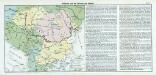
Nr. 17. Bulgarien und die Nationen des Balkans
Balkanhalbinsel, Bulgarien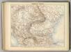
Hongrie et Turquie.
1 : 2400000 Jouvet et Cie.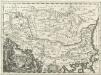
Tabula Veteris Pannoniae, Daciae et Illyrici
1 : 4400000 Mollova mapová sbírka Bruggen, Johann van der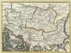
Tabula Veteris Pannoniae, Daciae et Illyrici
1 : 4400000 Mollova mapová sbírka Bruggen, Johann van der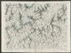
Walachia Serbia, Bulgaria, Romania. [Karte], in: Theatrum orbis terrarum, sive, Atlas novus, Bd. 1, S. 111.
1 Karte aus Atlas Blaeu, Joan Blaeu, Willem Janszoon
Etats Danubiens.
1 : 2500000 Vivien St Martin, L.
Turkey
1 : 12330000 Turecko Walker, C. Baldwin & Cradock
Ancient Macedonia, Thracia, Illyria, Moesia, and Dacia
1 : 3000000 published under the superintendence of the Society for the Diffusion of Useful Knowledge engraved by J. & C. Walker London : Baldwin and Cradock
Hvngariae ampliori significatu et veteris vel methodicae complexae regna: Hvngariae propriae, Croatiæ, Dalmatiae, Bosniae, Serviae, Bvlgariae, Cvmaniae, principatvm: Transylvaniae, despotatvs: Walachiae, Moldaviae [exclusis ab eadem alienatis Galitia et Lvdomiriria] in suas provincias ac partes divisae et quo ad imperanies ex Avstriacis, Tvrcis et Venetis distinctae [juncta tamen propter comoditatem Romania vel Romelia tvrcica] tabvla
1 Karte : Kupferdruck ; 45 x 57 cm Haas curantibus Homannianis Heredibus
Turkey in Europe.
1 : 4000000 Colton, G.W.
Map of the Balkan States
Balkanhalbinsel
Turkey in Europe.
1 : 3000000 Colton, G.W.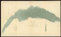
Walachia Servia, Bulgaria, Romania [Karte], in: Gerardi Mercatoris Atlas, sive, Cosmographicae meditationes de fabrica mundi et fabricati figura, S. 481.
1 Karte aus Atlas Mercator, Gerhard Montanus, Petrus