Maps of Lille
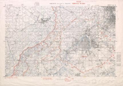
Belgium and part of France. Lille defence works.
1 : 40000 First World War map of Belgium and part of France. Lille defence works. Fifth edition. Information overprinted in red. War Office
Ryssel oder Lille mitt nahe anliegender Gegend
1 : 132000 Lille (Francie) Bodenehr, Gabriel G. Bodenehr
Ryssel oder Lille Mitt Nahe anliegender Gegend.
1 : 130000 Mollova mapová sbírka Bodenehr, Gabriel Bodenehr, Gabriel
Plan de la ville de Lille : investie par les Haut-Allies sous le commandement de S. A. le Prince Eugene de Savoye le 13. Aoust et prize le 8. Octobre 1708, où l'on void comment et par où elle a esté attaquée
1 : 25000 dessinné sur le lieu avec la derniere exactitude par Monsr. Brüchman, capitaine ...
Ditiuncula in Confiniis | Flandriæ Gallicanæ | sita, vulgo | LE PAYS DE | LALLEVE | Sub Dominio Abbatis | S. Vedasti ad Atrebatum
Vedastus du Plouich auctore ; V. du Plouich fecit [Amsterdam : Joan Blaeu]
Zur Belagerung von Lille
Lille (Francie) Fricx, Eugene Henry K.k. Generalstabes
Plan du siège de Lille avec des environs [1708]
1 : 17000 P. v. Cal fecit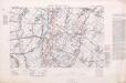
Brigade Trench Map. Area M. 1916
1 : 10000 First World War map. Brigade Trench Map. Area M. 1916. In margin: 'Notes on country and enemy's positions on the III Corps Front'. War Office
Lille. 1917.
1 : 20000 First World War map. Lille. 1917. Shows all bridges. War Office
Plan de la ville de Lille investie par les Haut-Allies sous le commandement de S.A. le prince Eugene de Savoye le 13. aoust et prize le 8. octobre 1708 ou l'on void comment et par ou elle a esté attaquée
1 : 24000 Lille (Francie) Fricx, Eugene Henry Brüchman chez Eugene Henry Fricx
Plan de la ville et citadelle de Lille: la ville fut attaquée par les Alliés sous le commandement de S. A. Le Prince Eugene de Savoye le 22. Aoust, & se rendit le 22. Octobre 1708 : l'ennemy s'estant retiré par accord dans la citadelle, elle fut pareil [...]
1 : 10000 par Mons.r. Brüchman
Plan de la ville et citadelle de Lille
1 : 25000 Lille (Francie) Fricx, Eugene Henry Brüchman chez Eugene Henry Fricx
Das belaegerte Kyssel
Lille (Francie) bey Johann Jonathan Felßeckern sel. Erben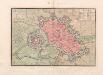
A colored plan of "Lille
A colored manuscript plan of Lille, France; "drawn about 1720, on a scale of 120 toises to an inch."
Lilla in Fiandra
Lille (Francie) Gualdo Priorato, Galeazzo Hacque, Johann Baptist Gio. Battista Hacque
Lilla in Fiandra
Lille (Francie) Gualdo Priorato, Galeazzo Hacque, Johann Baptist Gio. Battista Hacque
INSVLA, | Vulgo | LILLE, | Belgice | RIISSEL
[Amsterdam : Joan Blaeu]
Plan de la citadelle de Lille: laquelle, apres que la ville fut prise le 22. Octobre, on a aussi commencé d'attaquer sous le commandement de S. A. Le Prince Eugene de Savoye dès le 29. et ainsi continué ... iusques au 8. Decembre 1708 ...
1 : 4450 par le Sieur Brüchman capitaine ...
ARMENTIERES
Vedastus de Plouich Fecit [Amsterdam : Joan Blaeu]
PLAN DE LA CITADELLE DE LILLE
1 : 4500 Lille (Francie) Fricx, Eugene Henry Brüchman chez Eugene Henry Fricx
Plan des attaques de la ville de Lille commencées sous le commandement de S.A.S. le prince Eugene de Savoye le 22. aoust et finies le 22. octobre 1708, jour de la reddition
1 : 4500 Lille (Francie) Fricx, Eugene Henry Brüchman chez Eugene Henry Fricx
Map of water supply: Lille
1 : 100000 Series of maps on water supplies. Lille War Office
Plan parcellaire de la commune de Ploegsteert : avec les mutations
1 : 5000 Royal Library of Belgium Map Room Popp, Philippe Christian (1805-1879) Popp, Philippe Christian (1805-1879)
Plan parcellaire de la commune de Warneton : avec les mutations
1 : 2500 Royal Library of Belgium Map Room Popp, Philippe Christian (1805-1879) Popp, Philippe Christian (1805-1879)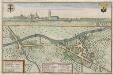
STEGERS Gallice ESTAIRES : [plan and view]
[Amsterdam : Joan Blaeu]
Plan parcellaire de la commune de Neuve-Eglise : avec les mutations
1 : 5000 Royal Library of Belgium Map Room Popp, Philippe Christian (1805-1879) Popp, Philippe Christian (1805-1879)
Galloflandria
1 : 170000 Douai (Francie) Doué, Martin Blaeu, Willem Janszoon Guiljelmus Blaeu
Flandriae Comitatus Pars Australis
1 : 133000 Mollova mapová sbírka Visscher, Nicolaes Schenk, Peter II
Flandriae comitatus pars Australis, in Castellaniam insulanam, Balliviatum duacensem, territorium Tornacensem, et in suasquasque ditiones subjacentes
1 : 140000 accuratissima divisa per Nicolaum Visscher Amst. Bat. Amst. Bat. : per Nicolaum Visscher