Maps of Vauban Esquermes

Lille. 1917.
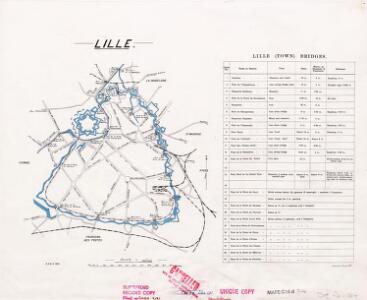
1 : 20000 First World War map. Lille. 1917. Shows all bridges. War Office
Das belaegerte Kyssel
Lille (Francie) bey Johann Jonathan Felßeckern sel. Erben
Plan de la ville et citadelle de Lille: la ville fut attaquée par les Alliés sous le commandement de S. A. Le Prince Eugene de Savoye le 22. Aoust, & se rendit le 22. Octobre 1708 : l'ennemy s'estant retiré par accord dans la citadelle, elle fut pareil [...]
1 : 10000 par Mons.r. Brüchman
Plan de la ville de Lille investie par les Haut-Allies sous le commandement de S.A. le prince Eugene de Savoye le 13. aoust et prize le 8. octobre 1708 ou l'on void comment et par ou elle a esté attaquée
1 : 24000 Lille (Francie) Fricx, Eugene Henry Brüchman chez Eugene Henry Fricx
A colored plan of "Lille
A colored manuscript plan of Lille, France; "drawn about 1720, on a scale of 120 toises to an inch."
Lilla in Fiandra
Lille (Francie) Gualdo Priorato, Galeazzo Hacque, Johann Baptist Gio. Battista Hacque
Lilla in Fiandra
Lille (Francie) Gualdo Priorato, Galeazzo Hacque, Johann Baptist Gio. Battista Hacque
Plan de la ville et citadelle de Lille
1 : 25000 Lille (Francie) Fricx, Eugene Henry Brüchman chez Eugene Henry Fricx
INSVLA, | Vulgo | LILLE, | Belgice | RIISSEL
[Amsterdam : Joan Blaeu]
Plan de la citadelle de Lille: laquelle, apres que la ville fut prise le 22. Octobre, on a aussi commencé d'attaquer sous le commandement de S. A. Le Prince Eugene de Savoye dès le 29. et ainsi continué ... iusques au 8. Decembre 1708 ...
1 : 4450 par le Sieur Brüchman capitaine ...
PLAN DE LA CITADELLE DE LILLE
1 : 4500 Lille (Francie) Fricx, Eugene Henry Brüchman chez Eugene Henry Fricx
Plan des attaques de la ville de Lille commencées sous le commandement de S.A.S. le prince Eugene de Savoye le 22. aoust et finies le 22. octobre 1708, jour de la reddition
1 : 4500 Lille (Francie) Fricx, Eugene Henry Brüchman chez Eugene Henry Fricx
Plan du siège de Lille avec des environs [1708]
1 : 17000 P. v. Cal fecit
Zur Belagerung von Lille
Lille (Francie) Fricx, Eugene Henry K.k. Generalstabes
Plan de la ville de Lille : investie par les Haut-Allies sous le commandement de S. A. le Prince Eugene de Savoye le 13. Aoust et prize le 8. Octobre 1708, où l'on void comment et par où elle a esté attaquée
1 : 25000 dessinné sur le lieu avec la derniere exactitude par Monsr. Brüchman, capitaine ...
Ryssel oder Lille Mitt Nahe anliegender Gegend.
1 : 130000 Mollova mapová sbírka Bodenehr, Gabriel Bodenehr, Gabriel
Ryssel oder Lille mitt nahe anliegender Gegend
1 : 132000 Lille (Francie) Bodenehr, Gabriel G. Bodenehr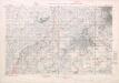
Belgium and part of France. Lille defence works.
1 : 40000 First World War map of Belgium and part of France. Lille defence works. Fifth edition. Information overprinted in red. War Office
Map of water supply: Lille
1 : 100000 Series of maps on water supplies. Lille War Office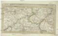
Menin in Flandern mitt nahegelegenen Staedten Ypern, Cortryck, Ryssel, Dornick etc
1 : 252000 Flandry Bodenehr, Gabriel G. Bodenehr
Lille La Bassée

Carte Particuliere des Environs de Lille Tournay, Valenciennes, Bouchain, Douay, Arras, Bethune
1 : 116600 Mollova mapová sbírka Fricx, Eugène Henry Covens, Johannes I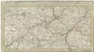
Menin in Flandern mitt nahe gelegenen Staedtten Ypern, Cortryck, Ryssel, Dornick etc.
1 : 250000 Mollova mapová sbírka Bodenehr, Gabriel Bodenehr, Gabriel
Le Diocese de Tournay
1 : 150000 Mollova mapová sbírka Cappelier, Bernard Jaillot, Alexis Hubert
Carte particuliere des environs de Lille, Tournay, Valenciennes, Bouchain, Douay, Arras, Bethune
1 : 116600 Mollova mapová sbírka Fricx, Eugène Henry Harrewyn, Jacques Fricx, Eugené Henry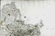
[Lille]
1 Blatt : 60 x 91 cm s.n.
Plan de la situation de l'Armée allié campée au bord de l'Eescaut 1744, de même que l'Armée françoise, retranchée derrière La Lis, l'année 1744
1 : 140000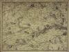
Carte particuliere des environs de Lille, Tournay, Valenciennes, Bouchain, Douay, Arras, Bethune
1 Karte : Kupferdruck ; 40 x 55 cm Fricx; Harrewijn chez Eugene Henry Fricx ruë de la Madelene
Galloflandria
1 : 170000 Douai (Francie) Doué, Martin Blaeu, Willem Janszoon Guiljelmus Blaeu