Maps of Belgium

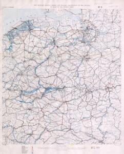
Map showing Railway system and Military organization of the country in rear of the enemy’s lines (in France and Belgium)
1 : 250000 Map showing Railway system and Military organization of the country in rear of the enemy’s lines (in France and Belgium) War Office
Water supply Map of France and Belgium
1 : 250000 First World War map of water supply Map of France and Belgium. Showing relative abundance of water during dry summer months. War Office
Carte routière de la Belgique : à l'usage des touristes, cyclistes et automobilistes / publié sous la dir. de Aug. Fourmanois ; exécutée à l'établissement cartographique E. Patesson
1 : 320000 Fourmanois, Aug.; Établissement cartographique E. Patesson, Brussel Bruxelles : Touring Club de Belgique
Carte des chemins de fer de la Belgique, uit: Carte des chemins de fer de la Belgique
1 : 370000 [Bruxelles : Ministère des Chemins de Fer, Postes et Télégraphes]
Comitatus Hannoniae in suas quasque castellanias Balliviatvs praefecturas et territoria accurate divisi descriptio
1 : 230000 Belgie Homann, Johann Baptist J.B. Homann
Comitatus Hannoniae in suas quasque Castellanias Balliviatvs praefecturas et territoria accurate divisi descriptio
1 : 300000 Belgie Homann, Johann Baptist Ioh. Bapt. Homanno
Carte routiere du théatre de la guerre, contenant la Flandre, partie du Brabant et du Comte de Namur : dressée d'après la grande carte de Ferraris ...
1 : 250000 Annotatie: Het impressum vermeldt als jaar van uitgave: l'an 2eme de la République Française Paris : Basset
Les provinces des Pais Bas Autrichiens
Belgie Seutter, Matthäus par Matthieu Seutter
Le Theatre de Bellone :
Mollova mapová sbírka Schenk, Pieter Braakman, Adriaan
Comitatuum Hannoniae Et Namurci Descriptio. [Karte], in: Gerardi Mercatoris et I. Hondii Newer Atlas, oder, Grosses Weltbuch, Bd. 1, S. 437.
1 Karte aus Atlas Mercator, Gerhard und Hondius, Jodocus Jansson, Jan
Comitatuum Hannoniae Et Namurci Descriptio. [Karte], in: Novus atlas absolutissimus, Bd. 3, S. 144.
1 Karte aus Atlas Janssonius Offizin
Hannonia. Namurcum Comitatus [Karte], in: Gerardi Mercatoris Atlas, sive, Cosmographicae meditationes de fabrica mundi et fabricati figura, S. 311.
1 Karte aus Atlas Mercator, Gerhard Montanus, Petrus
Comitatuum Hannoniae Et Namurci Descriptio. [Karte], in: Novus Atlas, das ist, Weltbeschreibung, Bd. 1, S. 348.
1 Karte aus Atlas Blaeu, Joan Blaeu, Willem Janszoon
Flandriae comitatus
1 : 300000 Flandry Visscher, Nicolaus Nicolaes Visscher
FLANDRIAE COMITATUS Accuratissima Descriptio
1 : 300000 Flandry Visscher, Nicolaus by Nicolaes Visscher
Les Campemens des armées du Roy dans les Pays-Bas
1 : 855000 Mollova mapová sbírka Moullart-Sanson, Pierre
Les Campemens des armées du Roy dans les Pays-Bas
1 : 855000 Mollova mapová sbírka Moullart-Sanson, Pierre
Les Campemens des armées du Roy dans les Pays-Bas
1 : 855000 Mollova mapová sbírka Moullart-Sanson, Pierre
Les Campemens des armées du Roy dans les Pays-Bas
1 : 855000 Mollova mapová sbírka Moullart-Sanson, Pierre
Comitatuum Hannoniae Et Namurci Descriptio. [Karte], in: Theatrum orbis terrarum, sive, Atlas novus, Bd. 1, S. 394.
1 Karte aus Atlas Blaeu, Joan Blaeu, Willem Janszoon
Tableau indicatif du chemin de fer, 1837 ; Carte des chemins de fer de la Belgique
1 : 1150000 Bruxelles : Etablissement Géographique
Comitatus Flandriae tabula
1 : 284000 Flandry Wit, Frederick de Deur, Abraham F. de Wit
Comitatus Flandriae tabula
1 : 280000 Flandry Wit, Frederick de Deur, Abraham Frederico de Wit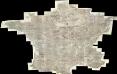
Composite: Carte de France.
1 : 86400 Cassini family; Cassini, Cesar-Francois, 1714-1784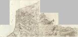
Composite 1: Carte de France.
1 : 86400 Cassini family; Cassini, Cesar-Francois, 1714-1784
Flandriae Comitatus Accuratissima Descriptio [Karte], in: Novus atlas absolutissimus, Bd. 3, S. 109.
1 Karte aus Atlas Janssonius Offizin
Carte de la Picardie, Artois, Boulonois, Flandre françoise, Haynaut et Cambresis, 2
2 Blätter : 62 x 43 cm Bourgoin
Eisenbahn-Nachträge zu Kiepert's Handatlas
Neuer Handatlas über alle Theile der Erde Kiepert, Heinrich Verlag von Dietrich Reimer