Maps of Istanbul
Constantinople & surrounding country, G.S.G.S. no 2390 (Sheet 4)
Constantinople & surrounding country, G.S.G.S. no 2390. Great Britain. War Office. General Staff. Geographical Section. [London] : Geographical Section, General Staff
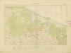
Rechter Flügel der Tschataldja-Linie
1 : 105000 Türkei Osmanisches Reich Balkankrieg <1912-1913> Çatalca Çatalca / Schlacht
Gelände des Erkundungsrittes, auf dem der Verfasser verwundet wurde
Türkei Osmanisches Reich Balkankrieg <1912-1913> Mahmud, Muhtar Paşa
Italien und Balkanhalbinsel. Nebenkarten II. 2. Konstantinopel und der Bosporus
Istanbul, Bosporus
Plan del canal desde Constantinopla al mar Negro
Bospor (Turecko : průliv) Velazques, J. Vazques, J.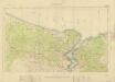
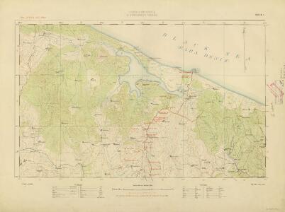
Constantinople & surrounding country, G.S.G.S. no 2390 (Sheet 2)
Constantinople & surrounding country, G.S.G.S. no 2390. Great Britain. War Office. General Staff. Geographical Section. [London] : Geographical Section, General Staff
Generalkarte von Zentraleuropa

Übersichtskarte
1 : 400000 Türkei Osmanisches Reich Balkankrieg <1912-1913> Mahmud, Muhtar Paşa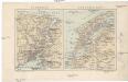
Bosporus, Dardanellen
Bospor (Turecko : průliv) F. A. Brouckaus' Geogr.-artist. Anstalt
Charte von der Strasse der Dardanellen oder Hellespont und dem Canal Constantinopel (Bosporus) nebst dem Meer von Marmora mit den anliegenden Gegend von Europa und Asia
1 : 540000 Bospor (Turecko : průliv) Güssefeld, Franz L. Faden, W. A.G. Schneider u. Weigel
Die Dardanellen in ihrer Lage zu Konstantinopel
Dardanellen
Konstantinopel, Šumla, Adrianopel, Dimotika
1 : 750000 Edirne (Turecko : oblast) Fendl. J. K. u. k. Militärgeographisches Institut
Constantinopel, Šumla, Adrianopel, Dimotika
1 : 750000 Edirne (Turecko : oblast) K. k. militär-geographisches Institut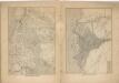
Kriegs Atlas 36 Karten von den Schauplätzen des Weltkrieges 1914/1915

Übersichtskarte von Mittel - Europa
A2. Constantinopel. / bearbeitet von Richard Kiepert. 1902-1916.
From 2nd Edition. 1: 400,000. 1908-1914.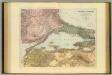
Sea of Marmara.
1 : 575300 Stanford, Edward
Ostthrakien
Ostthrakien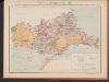
Carte des écoles et églises du vilayet d'Andrinople du sandjak de Tchataldja et de la partie européenne du vilayet de Constantinople (1908)
Türkei Vilâyet Edirne Ejalet Istanbul Sandschak Çatalca Kirchenbau Kümmerly & Frey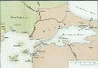
[Konstantinopel]
Istanbul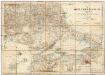
Karte vom Östlichen Rumelien
1 : 540000 Východní Rumelie Kiepert, Heinrich Dietrich Reimer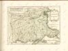

Charte des Kriegsßchauplatzes von der niedern Donau bis Constantinopel
1 : 600000 Bospor (Turecko : průliv)
Karte der Hauptstrassen von der niedern Donau bis Constantinopel
1 : 600000 Bospor (Turecko : průliv) Zirbeck, Carl k. p. Generalstab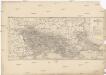
Carte de la Thrace d'une partie de la Macédoine et de la Moesie
1 : 800000 Makedonie Viquesnel, A. Charle Gide et J. Baudry
Situations Zeichnung desjenigen Theils von Bulgarien und Romanien
1 : 1100000 Bulharsko Ferd. Steinkopf
Demilitarized zones in north-west Turkey
1 : 1000000 Demilitarized zones in north-west Turkey. Illustrates post-war settlement. War Office
Balkans 1 000 000e. Constantinople
1 : 1000000 France. Service géographique de l'armée [Paris] : Service géographique de l'armée
Boundary of demilitarized zone about Constantinople
1 : 1000000 Meeting of Alllied Naval and Military Advisers, London 16.2.20. Demilitarized zones in north-west Turkey. Illustrates post-war settlement. War Office