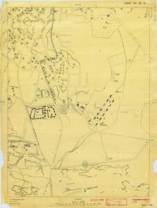
Maps of Nicosia

Cyprus 1: 2, 500 (Sheet XXI 55W) 1935a
[Cyprus]. Cyprus. Land Registration & Survey Department. Nicosia : Land Registration & Survey Dept.
Cyprus 1: 2, 500 (Sheet XXI 55W) 1935
[Cyprus]. Cyprus. Land Registration & Survey Department. Nicosia : Land Registration & Survey Dept.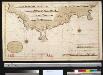
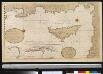
De Zuijd kust van het eijland Cijprus geleegen agter in de Middellandsche Zee met alle desselfs havenen en baaijen
Cyprus Gerard van Keulen
Cyprus ins
1 Karte : Kupferdruck ; 23 x 48 cm, Bildgrösse 35 x 50 cm Hondius; Mercator Henricus Hondius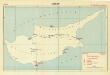
Zypern, Cyprus (Sheet 2)
Orientierungsmappe Mittlerer Osten. Heft IX: Cypern (CY). [Berlin] : Der Oberbefehlshlshaber der Luftwaffe, Fu̡hrungsstab IC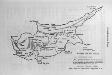
Landkarte von Zypern
Zypern
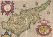
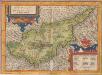
Cyprvs insvla
1 : 600000 Kypr apud I. Cóvens et C. Mortier
CYPRVS | INSVLA.
[Amsterdam : Joan Blaeu]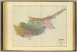
Cyprus.
1 : 348480 Stanford, Edward

Cypri Insulae Nova Descript. 1573. [Karte] Lemnos Insulae [Nebenkarte], in: Theatrum orbis terrarum, S. 249.
1 Karte aus Atlas Ortelius, Abraham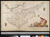
Het eijlandt Cijprus
Cyprus Gerard van Keulen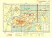
Zypern, Cyprus (Sheet 1)
Orientierungsmappe Mittlerer Osten. Heft IX: Cypern (CY). [Berlin] : Der Oberbefehlshlshaber der Luftwaffe, Fu̡hrungsstab IC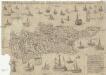
Cipern
Kypr Ienichen, Balthasar
Cyprus, que olim Macaria id est Beata, insula est in sinu Carpathii maris sita Veneri fuit sacra
Kypr Duchetti, Claudio Arrianos, Flavios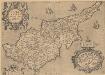
Cypri Insulae Nova Descript. 1573. [Karte] Lemnos Insulae [Nebenkarte], in: Theatrum orbis terrarum, S. 344.
1 Karte aus Atlas Ortelius, Abraham Vrients, Jan Baptista
Cyprus Insula [Karte], in: Novus Atlas, das ist, Weltbeschreibung, Bd. 2, S. 294.
1 Karte aus Atlas Blaeu, Joan Blaeu, Willem Janszoon
Cyprus Insula. [Karte], in: Theatrum orbis terrarum, sive, Atlas novus, Bd. 2, S. 277.
1 Karte aus Atlas Blaeu, Joan Blaeu, Willem Janszoon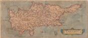
Cyprus Insula [Karte], in: Theatrum orbis terrarum, S. 93.
1 Karte aus Atlas Ortelius, Abraham
Cyprus Insula. [Karte], in: Le théâtre du monde, ou, Nouvel atlas contenant les chartes et descriptions de tous les païs de la terre, Bd. 2, S. 270.
1 Karte aus Atlas Blaeu, Willem Janszoon und Blaeu, Joan Blaeu, Willem Janszoon
Cyprus Ins: [Karte], in: Gerardi Mercatoris Atlas, sive, Cosmographicae meditationes de fabrica mundi et fabricati figura, S. 523.
1 Karte aus Atlas Mercator, Gerhard Montanus, Petrus
Cyprus Insula [Karte], in: Novus atlas absolutissimus, Bd. 6, S. 99.
1 Karte aus Atlas Janssonius Offizin
Historický atlas revolučního hnutí
Insular. Aliquot Aegaei Maris Antiqua Descrip.[:] Cyprus, Insula laeta choris, blandorum et mater amorum. [Karte], in: Theatrum orbis terrarum, S. 419.
1 Karte aus Atlas Ortelius, Abraham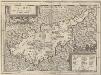
Insular. Aliquot Aegaei Maris Antiqua Descrip.[:] Cyprus, Insula laeta choris, blandorum et mater amorum. [Karte], in: Theatrum orbis terrarum, S. 517.
1 Karte aus Atlas Ortelius, Abraham Vrients, Jan Baptista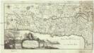
Carte de la Terre Promise
1 : 1600000 Izrael
Judaea seu duodecim tribus Israelis
1 : 10670000 Izrael Bonne, Rigobert André
Feuille No. 8, uit: Carte de la Turquie d'Asie (moins l'Arabie) / dessiné et héliogravé au Service géographique de l'Armée
1 : 1000000 titelvariant: Turquie d'Asie; Annotatie: Titel boven de kaart: Turquie d'Asie; Bl. genummerd 1-4 en 7-10; Met lijst van de meest gebruikte woorden op de kaart vertaald uit het Turks, Arabisch en Perzisch; Annotatie geografische gegevens: Inzetkrt. op bl. 9: Plan de Jérusalem et de ses environs, Plan d'Alep, Plan de Damas et de ses faubourgs, Plan de Beyrout et de ses environs (alle 1:50.000) Service géographique de l'Armée [S.l. : Service géographique de l'Armée]